|
|
Route |
|---|---|
|
|
40.74700°N / 110.81944°W |
|
|
Hiking, Scrambling |
|
|
Summer, Fall |
|
|
Most of a day |
|
|
Class 2 & 3, two sections of Class 4 |
|
|
Overview
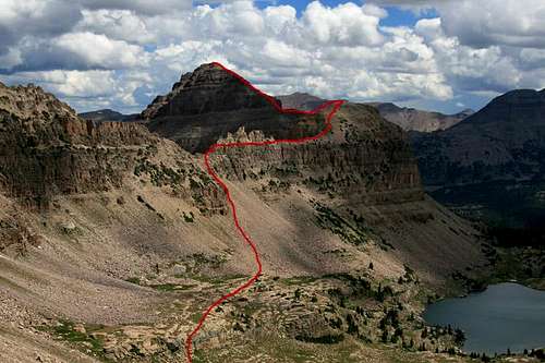
The south ridge route on East Hayden Peak is the shortest route to gain the summit. If you are familiar with the popular south ridge on Hayden Peak, the terrain is very similar. In comparison, I would rate East Hayden Peak as a more challenging route. The increased distance and increased elevation gain are part of the equation, and there is also more exposure. The exposure is very similar to Hayden Peak, there is just more of it.This route is a great scramble with incredible views. The location of the route in the Middle Basin of the Stillwater Fork also has a neat, remote feel to it that adds to the fun. On our entire day trip the only companions we saw were some fish, a few birds, and a marmot. Aaaaahhh, solitude!
South Ridge route as viewed from the top of the Hayden/Agassiz Ridge.
Getting There
East Hayden Peak is most accessible from the Utah Highway 150 (Mirror Lake Highway) that travels through the western region of the Uinta Mountains.To reach this Highway use the following instructions: from Salt Lake City, go south on Highway 40 out of Park City. From Provo, go north on Highway 40 out of Heber City. On Highway 40, go to the Park City/Kamas Exit (exit 4). At the stop sign turn right (onto Highway 189), and go roughly 12 miles to the town of Kamas. In Kamas, follow the road to Center Street and turn right (east) onto Highway 150. Highway 150 is the Mirror Lake Highway and will take you up into the Uinta Mountains.
Take Utah Highway 150 (Mirror Lake Highway) to the Highline Trailhead which is roughly 1/4 to 1/2 mile north of Mirror Lake. There is a large sign on the side of the road marking the parking lot to the Highline Trailhead.
Route Description

Looking down into the Middle Basin from the top of the Hayden/Agassiz Ridge

At the south ridge saddle, looking at the Class 4 chimney.

The narrow cliff traverse on the descent.

Just after the narrow ridge traverse.

Flat section of ridge leading to the final push.
From this saddle you have an awesome view of the fun terrain ahead. Take a short Class 4 chimney on the left of the ridge. Once you're above the chimney follow a narrow ledge that traverses the right (south) side of the cliff band. The ledge varies between 5-15 feet wide. The exposure is moderate. Technically speaking it's really only Class 2 terrain, just make sure you are comfortable with the exposure. The ledge is wide enough to make the travel easy.

Summit looking west at Hayden Peak
After the narrow cliff traverse, simply follow the ridge to the top. The section after the narrow cliff traverse is really cool. The terrain is easy, but the views are unbelievable! The terrain flattens out for a while and then approaches the final section to the summit. That final section is easy Class 3 scrambling.
Important Note: It's important to note that summer thunderstorms in this area can be dangerous and violent. In the Uintas, afternoon thunderstorms are nearly a daily constant. Travel very early to avoid the daily storms. Getting stuck on those high ridges in a thunderstorms would be a very scary situation.
Essential Gear

Reflections in the streams leading away from Hayden Peak.

Another view of the narrow ridge section on descent.