
|
|
Route |
|---|---|
|
|
36.32619°N / 75.38475°E |
|
|
Mountaineering |
|
|
Summer |
|
|
Expedition |
|
|
AD- |
|
|
Overview
This route was first completed in 1988 by Ernie McGlashan, Jack Brindle and John O'Reilly. It is relatively straight forward although requires a good level of fitness. It is also relatively safe (at least it was in June). The route up the northwest face passes under seracs however exposure time is minimal and there was no sigh of any avalanche debris when I climbed. The route described on this page is that completed by myself in 2006. While it approximates the same route taken in 1988 it may differ subtly as I have only read the 1988 climbing report in the American Alpine journal and not the full expedition report held in the Alpine club library. Northwest face & north ridge route on Yazghil Sar
Getting There
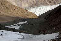
Having crossed the Yazghil glacier (See 'Getting There' on main page) a clear trail climbs from a good campsite (3300m) on the immediate eastern edge of the glacier. It climbs steeply, winding back and forth, eventually reaching a shepherdesses settlement at around 3800m. We camped here although it was less than ideal as the site had no water. Water is found a couple of hundred meters higher however you will likely need help to find the source. Ask either the shepherdesses or your porters (don't climb 500m by yourself looking for it like I did!). The water is also silty. Besides this drawback, the campsite is a lovely spot with particularly good views of the Yazghil Glacier and Hispar Muztagh. Climb to camp at 3500m on Yazghil Sar Climb to camp at 3500m on Yazghil Sar |  3500m Camp 3500m Camp |
From this camping spot it is approximately three hours climb to what we named base camp at 4500m. The route to base camp from the shepherdesses hut climbed green slopes. There was no path so head for the rocky outcrop to the left at the base of the snowline. If in doubt bear left as base camp overlooked the Virzherav (Virjerab) glacier. There was a small trickle of water at the base camp beneath some rocks and marked by a cairn. A better source of clear water was found a couple on hundred meters to the south. We marked it with a large cairn. All campsites described are ideal for small/medium sized parties.
 Climb to BC Climb to BC |
 Base Camp Base Camp |
Route Description
The North-West Face
From base camp we made the unusual move of actually descending before starting to climb. We descended northwards down loose scree bearing eastwards as we approached the main glacier descending from Yazghil Sar. On reaching the glacier the route was fairly self-explanatory. Crampons were donned fairly soon in order to cross a section of hard ice although this could have been avoided by heading towards the centre of the glacier immediately upon descending on to it. The route climbs across a snow field beneath, and then to the left, of some prominent seracs although exposure time is minimal.
 Crossing a snow field a short distance above base camp Crossing a snow field a short distance above base camp |
To the left of the seracs the route climbs 'classic Karakoram' loose scree that is not particularly pleasant climbing however this only lasts for a couple of hundred meters before reaching another snow field. On reaching the top of the scree crampons should be donned.
 Top of the scree Top of the scree |
Climb the snow field and then continue up an attractive gully to the left hand side of the glacier. Maximum inclination is around 45 degrees and the gully does not receive the early morning sun so snow conditions should be good if there has been a freeze in the night.
 Climb to high camp Climb to high camp |
 Climbing gully to high camp (5100m) Climbing gully to high camp (5100m) |
After about 150m the gully broadens. Continue climb on the same line staying to the right of the rocks. After a further 150m the main ridge is reached from where there are good views to the east although be careful of the cornice. Bear right and climb the ridge a short way to an excellent campsite (5100m). We found this campsite to be an excellent high camp with stunning views to the north and west.
 Climbing the NW Face Climbing the NW Face |
 Climbing to high camp (5100m) Climbing to high camp (5100m) |
 Immediately below high camp Immediately below high camp |
The Northern Ridge
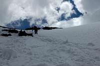
From the high camp it is a couple of hours climb to the main north ridge following an obvious route. Crevasses were few although we encountered some soft snow a short distance above the high camp. From high camp to the start of the north ridge it is approximately 300m. The start of the north ridge at around 5400m would also be an excellent place to camp although an early start would be required to reach it directly from BC. On the north ridge to the summit there were a couple of crevasses large enough to put a leg or two in June so roping up would be advisable for this stretch. The north ridge is straight-forward although fairly extensive. A short traverse along moderate steep snow is required midway along. On reaching the smaller northern summit the ridge descends a short way before again climbing. Again, take care with the cornices when ascending to the main southern summit. The summit is fairly broad and provides one of the best panoramas that I have seen in the Karakoram. Enjoy!
 North Ridge at sunrise North Ridge at sunrise |
 Close to the summit Close to the summit |
 Summit Summit |
Essential Gear
1 x Rope for moving togetherHarness
Screw gate karabiners
Slings
Crampons
Walking axe (1 axe is sufficient)
Walking poles
Snow Shovel useful for high camp