
|
|
Route |
|---|---|
|
|
41.71340°N / 111.7169°W |
|
|
Hiking |
|
|
Summer, Fall |
|
|
Most of a day |
|
|
Moderate to Strenuous |
|
|
Overview
Dry Canyon creates a deep cleft in the center of Mount Logan and is the first canyon south of Logan Canyon. It provides easy access to the summit of Logan Peak and is the most commonly used route to the top. It is about 4 miles long and gains about 4000 ft. of elevation. Rocks Near the Mouth of Dry Canyon
Getting There
 The Trailhead
Route Description
 Rocks at the Mouth of Dry Canyon.
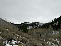 Logan Peak from Dry Canyon
At lower elevatations the forest consists mainly of Big Tooth Maples and juniper. In the summer it is quite shady in the bottom of the canyon. As you go higher the most prevalent trees become Aspen and it stays that way until you are nearly to the top. Then is is mostly pine and fir. The north wall of of the canyon is mostly bare and covered with brush but the south wall is covered mostly in pines for the entire distance.
For about the first 2 miles there is very gradual elevation gain and the trail is very well maitained but in the 3rd mile it starts to gain elevation rapidly, switchbacking up an Aspen covered ridge. Near the top of this ridge the main trail takes off to the west and follows the north wall for a while before is drops into Logan Canyon. DO NOT FOLLOW THE TRAIL. You will leave the trail at the top of the Aspen covered ridge. The last mile is a bushwhack and is quite steep. You will want to stay out of the trees as much as possible because there is a lot of dead fall. The best route would be to cut diagonally across the back of the canyon in a southern direction as you work your way to the top.
 The Route
Essential Gear
Dry Canyon is true to its name. It has no water. There is one spring if you continue along the established trail near where is goes over the ridge and into Logan Canyon but that is all and it is quite far out of your way. Just bring your own water.you will need a windbreaker or a jacket because the top is very windy.
If there is snow bring gaiters.
 Golden Aspens