
|
|
Route |
|---|---|
|
|
34.78787°N / 80.28603°E |
|
|
Mountaineering |
|
|
Expedition |
|
|
5.7 (YDS) |
|
|
High altitude mountaineering |
|
|
Overview
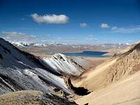 View down the route from 6000m.
The peak is a complex maze of rock towers, couloirs, ridges and whichever route you choose you'll be exposed to objective dangers. Rockfalls are common. The avalanche risk is always there as the snow sometimes stays longer and on steeper ground when it should in the narrow couloirs.
I'm not sure the below route is a very good one, but when I was there it looked like an interesting one and more suited for solo climbing than for example the northern approaches where the crevasse danger put me off from trying.
I failed to reach the summit. Had to turn back at 6370m. Couldn't justify what I was doing when the choices were steep and rotten rock or avalanche prone couloirs. This route description only goes to the point where I turned back. I hope it'll be of some help at least.
Getting There
See main page for a detailed description on how to get to the area.Short:
China - Xinjiang Province - Kashgar - Yecheng/Aba - Mazar - Dahongliutan - Sirengou Village.
How to get to the start of the route
Route Description
 The route
Ignore the valley on the left and go up the main valley leading east. In the beginning it's on gravel, but soon the snow takes over. At all times be aware of the rockfall danger! Starting early in the morning minimize the risk.
When you arrive at a big boulder in the middle of the valley, the route gets steeper. On your left you can see the end of small valleys/gullies in between sharp rock towers. Many of these gullies had avalanched when I was walking past. As they are in shadow a lot and the snow has been pressed in there, it's unpredictable stuff. Sometimes larger rocks came crashing down here also. Be careful.
When you arrive at a flatter section on an altitude of about 6000m, check your options and look for a good line in between the rock obstacles.
I went straight towards the highest point you can see above you. That gives you a straight line without rock on 45-50 degree snow. You climb on the right hand side of the largest rock outcropping.
When you have passed this, continue up to the first rock islands. These are of fine help if you need a rest and makes it safer in terms of avalanche danger.
I used them as stepping stones heading left towards the summit. When I was there, the strips of snow were very avalanche prone and sometimes I climbed on rotten and steep rock instead of using the snow too much.
What finally stopped me was a large section of steep snow, which only could've been avoided climbing straight up a rock tower to the summit ridge. The latter wasn't an alternative as the ridge was nothing but a nasty cornice up there.
Essential Gear
I was under-equipped. Period.To make a serious try on the peak, bring plenty of hardware to have options for the rotten rock. Snow stakes and/or a dead man may also come in handy in the couloirs and on the last snowy parts.
Technical axes, helmet, rope etc. basically all the normal stuff for a high alpine peak.
An alternative
 Route to west face
When at the place where i recommend to set BC, there's a canyon leading to the west face. I considered this an option until I saw fresh avalanche tracks on the face. The canyon itself is a bit dodgy. Large loose boulders, icy sections and rockfalls makes it hazardous. One option to the actual face could be to gain access to the NW ridge and then somehow pass the large rocky section.