|
|
Route |
|---|---|
|
|
38.67420°N / 106.2464°W |
|
|
Skiing |
|
|
Spring |
|
|
A long day |
|
|
WI 3, 50 degree snow |
|
|
5.4 (YDS) |
|
|
2 |
|
|
IV |
|
|
Overview
The North Face of Mount Antero is an anomaly in a sea of rolling peaks, and mellow descents. Rising 5,340 ft. from the Chalk Creek Road, this is an extreme ski/snowboard route only to be attempted by the fit, after close examination, and patience for the right conditions. Timing has to be perfect. It is not often that the snow line is very low in elevation, the avalanche danger low, and everything else lined up. I snowboarded the route on 5/11/07, and would like to call it the Caddis Route, after the celebrated Caddis hatch of the Arkansas River.Getting There
Park .25 mi east of Cascade Campground on the South Side of the Chalk Creek Road, CR 162. There is an old grade with a trail on it here.Route Description
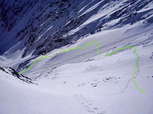
Follow the old grade for a short bit, then climb the embankment into the dense forest. Scope your route out in the light first. Find the bottom of the eastern most of the two main avalanche paths. Climb it to the ridge and Pt. 11432. The sky should just be starting to light up now. Traverse and bushwhack the E slopes for .5 mi at a slight downward trend to the mellow gully at 11200. Follow this untill merging with the main gully system at 11500. Skin as high as possible, then don the crampons and ice axes. Climb the obvious water ice that you scoped out prior. This is the 5.4 WI3 section. The first pitch is the longest, about 80 ft. The second shorter, but steeper WI 4+ which I gladly avoided with more moderate ice on climbers left. From here, climb a series of gullies and ribs up, traverse to the right, and follow an aesthetic rib to the summit. Snowboard or ski your ascent route. Rappel the ice. It is possible to avoid the steep ice, as I found out with a left angling gully to skiiers right of the ice, which was my descent route. Feel free to contact me for more beta. Let me know how it was!Essential Gear
beacon, shovel, probe, 2 ice axes, crampons, rope, harness, helmetExternal Links
Splitboard.com trip report,http://www.splitboard.com/talk/viewtopic.php?t=3697
http://www.wcc.nrcs.usda.gov/snotel/Colorado/colorado.html
http://avalanche.state.co.us/
http://www.fireweather.info/
www.wildsnow.com
Route Map

View of the upper traverse