Lower Sam Merrill Trail and Castle Canyon/Middle Sam Merrill Loop

Lower Sam Merrill Trail and Castle Canyon/Middle Sam Merrill Loop

Page Type Page Type: Route
Location Lat/Lon: 34.21100°N / 118.1205°W
Additional Information Route Type: Hiking
Additional Information Time Required: Half a day
Additional Information Difficulty: Trail and Firebreak
Sign the Climber's Log

Overview

Cobb Estate
Although the trail up Echo Mountain and further to Inspiration Point has been well described here on SP on mountain pages, in particular by Mountain Impulse (Echo Mountain, Inspiration Peak, Muir Peak), I felt the beauty and popularity of this hike deserves his own route page. This description covers the Lower Sam Merrill trail up Echo Mountain from the Cobb Estate trailhead, the Castle Canyon trail up to Inspiration Point (with a little side-kick up Inspiration Point) and back to Echo Mountain via the Middle Sam Merrill trail.
This page also intends to honor the various volunteers over the past decades, who helped to restore and maintain the trails around Echo Mountain after its glory days passed by in the late 1930’s. Without their continuous hard work and dedication countless hikers and mountain bikers alike would not be able to enjoy the beauty of this area. In this regard, Sam(uel) Merrill deserves great recognition. As a retired clerk of the Superior Court of Los Angeles and active member of the Sierra Club, Sam Merrill overhauled, maintained, and improved the trails up Echo Mountain in the 1940’s. After his death (shortly after he helped in a firefight in one of the canyons) in 1948 the trail from Altadena up Echo Mountain was named after him.

Getting There

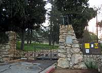
The trailhead for that route is the Cobb Estate at the north end of Lake Avenue in Altadena. Lake Avenue is also an exit of the 210 Freeway. The Cobb Estate, once a private residence, is used as a free growth botanical garden by the United States Forest Service since 1967. You can park on Lake Avenue or Loma Alta Drive. No Adventure Pass is required here.

Route Description

Echo Mountain
The Lower Sam Merrill trail starts about a hundred yards after the front gate of the Cobb Estate at the right side of the paved roadway (~1,820 ft). After crossing a dry riverbed the well maintained trail winds up the eastern slope of the lower Las Flores Canyon. At some points it actually crosses the ridgeline to allow very nice views at the lower parts of Rubio Canyon. After 2.6 miles the trail reaches Echo Mountain (3,207 ft), the site of the once glamorous White City.

From Echo Mountain the Castle Canyon trail leads north, first slightly descending and crossing the top of Rubio Canyon. The trail then ascends constantly and gets steep at the end climbing about 800 ft. in 0.3 miles. 2 miles after Echo Mountain it eventually tops out at the Ramada at Inspiration Point (4,510 ft). This lookout was a famous site at the times of the Mount Lowe Railway and has marvelous vistas over the mountains and canyons below and on clear days all the way to the ocean. There are several options here to add a few miles and peaks. If you take the fire road at the Ramada to the right (east) for about a mile, you will get to a small trail to the right leading up to Muir Peak. From the Ramada it is a brief excurse of about 0.2 miles and less than 200 feet elevation on a firebreak to a nearby peak (4,714 feet), which on Tom Harrisons Mt. Wilson Trail Map and on other Topo maps usually is called Muir Peak. Mountain Impulse rightfully claims that this peak is Inspiration Peak instead, while Muir Peak is east/southeast of Inspiration Point. Anyhow, from this peak, you are rewarded with great 360 degree views over the San Gabriel Front Range: Mount Lowe and the ridge leading to Tom Sloane Saddle and Brown Mountain to the north and northwest; antenna-covered Mount Wilson and Mount Harvard to the northwest; Muir Peak, Echo Mountain and the cities of the Los Angeles basin to the southwest and south.

Ramada at Inspiration Point
Back at the Ramada taking the fire road to the left (west) you reach a small saddle after about 300 yards, where the Idlehour Trail to Henninger Flats and the Middle Sam Merrill Trail back to Echo Mountain originate. Further down the fire road a trail leads north up Mount Lowe. Even further you reach Mount Lowe Trail Camp, the site of the once famous Alpine Tavern of the Mount Lowe Railway era. The Middle Sam Merrill trail (sometimes referred to as Upper Sam Merrill Trail; some refer to the continuation trail up Mount Lowe as the Upper Sam Merrill trail) parallels the fire road to the west on the south slopes of the Grand Canyon and on the north side of Inspiration Peak. Overlooking the top of Millard Canyon the trail then switches south and across the ridge and the top of Las Flores Canyon back to Echo Mountain. From the start of the Middle Sam Merrill trail to Echo Mountain you cover about 2.7 miles. Another 2.5 miles down Lower Sam Merrill trail brings you back to Cobb Estate. This route described here totals about 10.5 miles with ~2,800 feet elevation. Of note is that the Middle Sam Merrill Trail is very popular with Mountain Bikers. An early start and some caution are advisable.

Essential Gear

No special gear is necessary. Plenty of water is always needed. A vivid imagination and historical interest make this trip very worthwhile.

External Links

Add External Links text here.

Parents 

Parents

Parents refers to a larger category under which an object falls. For example, theAconcagua mountain page has the 'Aconcagua Group' and the 'Seven Summits' asparents and is a parent itself to many routes, photos, and Trip Reports.