
|
|
Route |
|---|---|
|
|
46.03330°N / 118.9605°W |
|
|
Hiking |
|
|
Spring, Summer, Fall, Winter |
|
|
Half a day |
|
|

Overview - Missoula Ice Age Flood hike
 The Wallula Gap Overlook
washington forever (or until the next glacial age flood). Carried on ice that came from Montana were different sizes of granite boulders which were
dropped on the landscape of the Mid-Columbia (eastern washington area) when
the ice carrying these boulders, called "erratics" melted and lost the payload it was carrying. One of these erratics is in an unbelievable location high on a plateau overlooking the Columbia River near Wallula Gap.
I won't try and give you the geologic history as so masterfully put together by author Bjornstad and also a second book titled "Glacial Lake Missoula and its Humongous Floods" by David Alt but perhaps this might whet your appetite for learning more about this amazing event. Nova/PBS put together an hour long documentary on these floods as well and perhaps you might have seen the show. Also check out Wikipedia's info on this. One more resource: HERE
Back to the overview of this hike. The hike begins in the area east of Finley Washington and allows you to get in some exercise and visit one of the ten geologic geocaches that Bruce Bjornstad had scattered around the
Mid Columbia area. This hike will take you to just one of the geocaches
but you'll traverse an area that few people really get to visit.
From this source, the following:
"More than 12,000 years ago the largest and most powerful scientifically documented freshwater flood to occur on earth happened in the Pacific Northwest. During the last ice age, ice sheets, at times reaching over 10,000 feet in thickness, covered much of Canada. A small lobe of the Cordilleran Ice Sheet called the Purcell Trench lobe advanced southward blocking the river in the Clark Fork Valley in northern Idaho and Montana with a 2,000 foot high and 30 miles wide ice dam. A glacial lake was created that covered much of present-day western Montana under approximately 2,000 feet of water in a 200-mile-long lake roughly the size of Lake Erie and Lake Ontario combined.
Eventually, 400-520 cubic miles of water burrowed into the ice dam, shattering it. The water roared out of the lake, swept across northern Idaho into eastern Washington, then rushed southwest across the Columbia Plateau, and split at a cliff--part of the flood traveled east up the Snake River but the main thrust traveled down the Snake and Columbia Rivers. The floodwaters, moving up to 60 miles per hour, stripped away the soil, scoured out hundred of miles of deep canyons called coulees (Grand Coulee being the largest), created the 3 ½ mile wide, 400-feet-high Dry Falls, the largest waterfall to ever exist, and the 198 feet Palouse Falls, and left 300 foot high gravel bars and huge granite boulders called glacial erratics. The muddy torrent carried water, chunks of ice, trees, gravel, soil, and boulders--some the size of small houses. The first floods carried more debris than the succeeding floods."
Another Ice Age Link
Getting There
From Seattle, Spokane or other points on the map, find your way to Kennewick Washington, and take the Columbia Drive exit ramp on the south side of the Blue Bridge (that spans the Columbia River) and head east.Topo one
Stay on Columbia Drive until you intersect with highway 397 (comes off of
the Cable Bridge) and turn south onto this road (also known as Chemical Drive)
Topo two
Follow this road as it heads towards Finley and then through it (not much to see)> When the road takes a jog south, it becomes Piert road and then turns
into Meals-Yellepit road
Topo three
Topo four
Stay on Meals-Yellepit road as it heads out into the country and follow it until you come to this dirt road and turn left
Topo five
Drive a short distance down this dirt road (Southeast) and watch for a parking area on the right. A hikers gate is located at the far end of this small parking area.
Topo six
I haven't given you mileage as it is a bit confusing and depends on where you actually start in Kennewick. From the Columbia Drive exit off of the highway, plan on somewhere between 9 and 11 miles. The topozone maps
will give you a good idea if you will take the time to study them.


Route Description
From the parking area, strike out towards the south on an obvious path that will tie into a ranch road. Be sure to leave the ranch gates as you find them as you encounter them on your hike. Permission to hike on this land isbeing granted courtesy of the ranchers who own it and will continue to be available as long as people respect the land and the owners rights.
The goal here is two fold. To find your way to the "erratic" and then on to
Wallula Gap point where the Bjornstad geologic geocache is hidden.
 Montana granite
Walk to this junction and take the left fork
Topo One
Your first major goal is just to the southeast on the 1100 foot plateau. Leave the road and work your way up the slopes to where the "erratic" is
sitting and enjoy the moment. Across the river are the "Twin Sisters",
another geologic wonder.
Topo Two (erratic)
After pondering how this big chunk on granite was deposited here (think glacial ice), start cross country towards where the Bjornstad geocache is
hidden and the Wallula Benchmark.
Topo Three (benchmark)
The geocache is hidden not far from the benchmark but it is hidden and will take some looking on your part to find it. Once you do find it, read the info inside, sign the logbook and carefully put it back so it'll be
safe for the next geocache seeker.
You can make your way back the way you came or take the roads which offer little resistance and perhaps a bit faster travel.
 Wallula Gap Overlook area.
Actual distance I hiked: 8 1/4 miles Elevation gain: 1800 feet.
An interesting number considering that the highest point of elevation
maxes out at 1140 feet. Plan on several hours to enjoy this hike.
Red Tape
The entire hike is on private ranch land and the ranchers have allowed hikersto visit the area and so please observe the open and close gate courtesy and leave no trash behind you. Pick up any that you find and this land should
continue to be open to hikers.

Weather

Camping
You could camp right at the trailhead if you are self contained. Bringear plugs however as the coyotes put up a beautiful seranade (all night)
Often you will be sharing the area with horse riders and they often will
camp in the same area but across the road from the parking area.
Columbia Park Campground
Motels aplenty in the tri city area.
Essential Gear
The usual common sense articles of clothing, you are in a desert environment. Rattlesnakes are found in this area so keep a sharp eye out during warmer weather and long pants and even gaiters might be a wise choice. Carryplenty of water and take a camera as in the spring there often is a myriad
of wildflowers to be enjoyed.
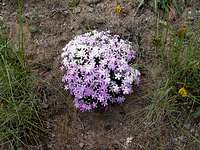 Phlox
PhloxFrom the geocache info
From Bjornstad's geocache you will find the following information:
"Wallula Gap, a natural water gap of the Columbia River, is one of the most significant and spectacular features created by the great Ice-Age floods. The National Park Service recognized this in 1980 by designating Wallula Gap a National Natural Landmark. Only one other flood feature in the Mid-Columbia Basin, Drumheller Channels, shares this distinction.
The story of Wallula Gap begins back in the Miocene Epoch, about 17 million years ago. At that time, lava flows of basalt ran out of giant fissures in the Earth’s crust east of here, near the Idaho-Oregon-Washington border. During basalt volcanism, the southern and western portions of the Columbia Plateau, including Wallula Gap, began to warp and fold under stresses deep in the Earth’s crust. The bending of the ancient lava flows is clearly visible in the folded layers of basalt exposed in the steep walls of the gap.
Early in the history of folding, the ridgecrest here was slightly lower than elsewhere along the ridge. This caused first the ancient Salmon-Clearwater River (precursor to the Snake River), and then the Columbia River to flow across the ridge over this low point. As the ridge continued to bend upward, river erosion kept pace, and a water gap developed. Until about 10 million years ago only the ancestral Salmon-Clearwater River flowed through Wallula Gap. It wasn’t until about 6 million years ago that the Columbia River joined in, where it has continued to flow ever since. Somewhere between 2 and 3 million years ago, the ancestral Salmon-Clearwater River captured the Snake River in the vicinity of Hell’s Canyon, along the Idaho-Oregon border; this added significantly to the amount of water draining through the gap.
Ice-Age floods, which began as early as 1 to 2 million years ago, took the path of least resistance. Since an opening across the Horse Heaven Hills already existed here, the floods naturally drained through Wallula Gap. No other place along the ridge was low enough to allow floodwaters to pass, so all the water was forced through this narrow opening, becoming a huge bottleneck. Floodwaters from Glacial Lake Missoula spread out over an area almost 100 miles wide across the Channeled Scabland, so its not difficult to understand why they backed up when suddenly forced to pass through an opening as small as two miles wide.
Geologists have calculated that during the Ice-Age floods, almost twice as much water entered the Gap than could pass through. The name for the body of water that backed up is Lake Lewis, a temporary lake that only lasted a week or less; the amount of time it took for all the water to drain through the gap. The water behind Wallula Gap also partially submerged a set of ridges that extend southeastward from Rattlesnake Mountain, forming the Lake Lewis Isles near the Tri Cities.
Ice-rafted erratics also are found to this elevation in the Pasco Basin, affirming the highest levels of Lake Lewis. (A number of light-colored, erratic boulders are visible along the route to the geocache). During the largest Ice-Age floods, water levels in Wallula Gap were almost 1000 feet deep! Downstream, the Columbia Gorge, also a narrow passage, caused floodwaters to back up, temporarily, to about 1100 feet below Wallula Gap. Floodwaters that backed up below Wallula Gap are referred to as Lake Condon.
The geocache is located at west side of Wallula Gap, at an incredible 850-ft drop off into the Columbia River below. Even at this height the largest Ice-Age floods still rose another 80 ft above the cache site.
To experience more incredible features left behind by the Ice-Age floods try finding these other geocaches placed by geologist Bruce Bjornstad:
Staircase Rapids
Upper Goose Lake
Frenchman Coulee Rib
Rattlesnake Slope Erratics
Devils Canyon
Saddle Mountains Overlook (Earthcache)
Potholes Coulee
West Bar Overlook
Lake Sacajawea Flood Bar
See this link for the above information complete with links and pics
Erratics in the tri-city area
Badger Mountain has been a place where I've spent many many hours hikingfor conditioning and enjoyment. On the side of Badger Mountain there are
many erratics, one deposited as high as 1125 feet. In an area where the
rock is volcanic in origin, it is a surprise to find these granite interlopers who came all the way from Montana to drop in on the area.
 Badger Mtn erratic
From another source (click here)comes this fascinating history:
"ScienceDaily (Nov. 4, 2003) — Seattle -- Geologists have uncovered a scene in the Pasco Basin west of the Columbia River in Washington state that shows how boulders piggybacked icebergs from what is now Montana and came to rest at elevations as high as 1,200 feet. Although glacial deposits of rocks and boulders are common, especially in the upper Midwest, "There probably isn't anyplace else in the world where there are so many rocks that rafted in on icebergs," said Bruce Bjornstad, a geologist at the Department of Energy's Pacific Northwest National Laboratory in Richland, Wash.
Bjornstad presented his team's results at the Geological Society of America Annual Meeting in Seattle today.
The rocks were left after ice dams holding back a huge lake near Missoula, Mont., broke, re-formed and broke again from 1 million to 2 million years ago to as recently as 13,000 years ago. The floodwaters backed up at the downstream end of the Pasco Basin behind Wallula Gap, a narrow ridge opening through which the Columbia River flows today. The lake lapped the gentle slope of Rattlesnake Mountain, northwest of the gap and part of the Hanford Reach National Monument in south-central Washington Rattlesnake Mountain was the highest peak protruding from the 800-foot-deep temporary body of water, dubbed Lake Lewis. The rocks and boulders, so-called erratics, grounded as the waters of Lake Lewis receded after a few days like a slowly draining bathtub. Bjornstad led a team that surveyed and analyzed the mostly-granite-strewn debris fields over 15 square miles of Rattlesnake Mountain. He said that the ice-rafted debris left deposits of three types: widely scattered rocks and boulders, distinct clusters and "bergmounds" – low, cone-shaped clumps of erratics that, like a moraine left by glaciers, alter the topography. Bjornstad's group discovered rafted rocks as long as 14 feet.
The erratics were concentrated along northeast-running gullies. Bjornstad suggests that the speed of the flowing water varied as it crossed an uneven surface, and that may have created eddies that forced an ice jam in the deeper, quieter waters at the back of these gullies. The erratics and bergmounds decreased as the surveyors worked up the mountainside. Bjornstad attributed the lower number to smaller successive floods."
Refer to the full article for more information but to me this stuff is
fascinating.
The Seattle PI paper had this article on the Glacial Floods:
Click HERE
Perhaps the biggest erratic found so far is this 100 ton boulder on the southwest side of Kennewick in Badger Canyon.
 100 Tons of granite
Local hiking group link
Please take a moment and click on this LINK. It'll bring up the InterMountainAlpine Clubs picture story of a hike to Wallula Gap.
Also included in the above article is a nice map of their hike.
Check it out HERE (MAP).
 Twin Sisters - across the Columbia
 I'm not through yet
I'll be adding more information to this page in the near future. If any of you reading this have done this hike, please add comments and pictures, it'll be appreciated.GEOLOGIC HISTORY OF THE WALLULA GAP (please read for more appreciation of this area)
CLICK HERE
 witness benchmark
I'll be adding more information to this page in the near future. If any of you reading this have done this hike, please add comments and pictures, it'll be appreciated.
Related to Wallula Gap's history - Palouse Falls
 Part of the legacy of the Glacial floods
"The floodwaters, moving up to 60 miles per hour, stripped away the soil, scoured out hundred of miles of deep canyons called coulees (Grand Coulee being the largest), created the 3 ½ mile wide, 400-feet-high Dry Falls, the largest waterfall to ever exist, and the 198 feet Palouse Falls, and left 300 foot high gravel bars and huge granite boulders called glacial erratics."
Source for above(read all of it)
Nearby Badger Mountain balsamroot
My favorite desert flora of the region are the Balsamroot and the Lupines.Here is a shot of Balsamroot taken on Badger Mtn.
