
-
 24110 Hits
-
 76.66% Score
-
 7 Votes
|
|
Route |
|---|---|
|
|
36.52302°N / 118.23958°W |
|
|
Mountaineering |
|
|
Spring, Summer, Fall, Winter |
|
|
One to two days |
|
|
Class 3 |
|
|
Overview
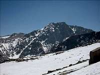 Looking from Lone Pine Peak. Photo by Rick Kent 4-20-08
The first ascent of the massive north face was made by Nelson P. Nies and Howard S. Gates in August 1937.
During the winter months Mt Langley gets few visitors. In 2008 I found only six summit log entries from November '07 to April '08. This is due in large part to the fact that the road to Horseshoe Meadow is typically closed from October to the end of May, adding an extra 13.5 extra miles to the trip each way.
With more that 7,000 ft of gain in 4.5 miles of cross country travel the south fork of Tuttle creek offers a hardy alternative.
Getting There
 Further up the road is out sloped and there are no turn arounds until the TH
Take the Whitney Portal road 3.2 miles and turn left onto Horseshoe Meadow road. Drive 2.0 miles south on Horseshoe Meadow road past the Tuttle Creek campground, turn right (west) onto Granite View road. This is a well maintained dirt road. Go 2.3 miles and turn right, follow this road to the trail head, about 2 miles to the end. The last half mile or so of this road is out sloped and it may be wise to park before the narrow section in foul weather.
Route Description
 The trail head.
Follow the trail from the parking area west for less than a mile. Here it turns north and crosses the south fork of Tuttle creek. It is tempting to follow the creek toward Langley's north side but it is much better to follow the trail to the north for a bit till you reach the abandoned stone house.
At the stone house, which was constructed as a Hindu ashram in the 1930's, look for a tin shed. Up this ridge to the tin shed and past a wickiup is the start of a use trail that will lead you well up the drainage on the north side of Tuttle creek.
The trail forks almost immediately; the left fork for uphill travel and the sandy right fork is used to descend.
 The sandy downhill trail is just under the rock wall. The uphill trail is to the left of the manzanita
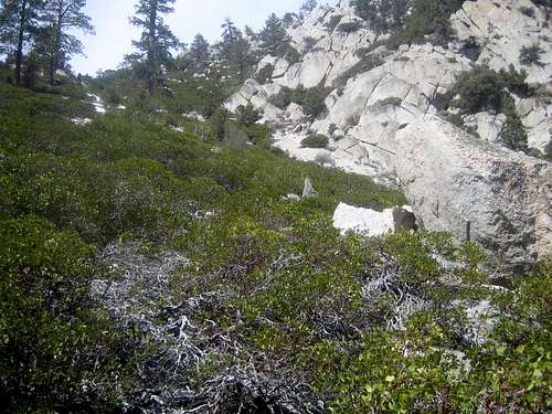
By following the use trail up the north side you avoid most of the thick brush and a water fall. You may be able to get a glimpse of the waterfall which is just below the large avalanche chute on the south side as you are traveling side hill and up the north side.
This use trail wanders between a rock face on the right and a manzanita patch on the left. At this point the route turns toward the west and the use trail becomes a jumble of animal trails, people tracks and an odd but sometimes useful string of cairns.
Here the canyon flattens out a bit you should be able to see Langley's north face. Taking the path of least resistance leads you to a 2nd creek crossing. Now on the south side of the creek the routes climbs to a bench that is roughly 10,000 feet and the trail disappears.
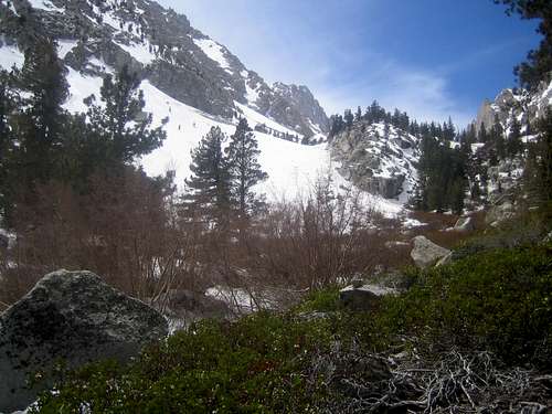 The first good view of the north face and the 2nd stream crossing.
The trees and boulders on this bench offer the last significant wind shelter for a bivy site.
Continue up the drainage by path of least resistance to about 11,500 ft. At which point a large ramp up the south slope leads to the base of the northeast couloir.
The northeast couloir proper starts at about 11,800 ft and tops out about 13,800 ft. On average it is about 40 degree climb, but maybe more than 50 degree at the top and up the last 200 ft of the east ridge to the summit.
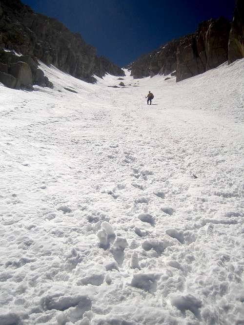 After climbing the north facing ramp you can see all the way up the north couloir.
Without snow the coulior is blocked at it top. Climb out of the chimney, then traverse left(southeast), then right (southwest) to a point on the ridge west of the summit. Follow the ridge left (east) to the top of the peak.
This route tops out with less than a 200 yard walk to summit.
 14,000' but not the summit. The route tops out just short walk from the true summit.
Red Tape
Tuttle Creek is a quota trail. Area J38Check road access and Snow conditions for winter trips!
Entry dates of November 1st to April 30 are non quota, no reservation needed.
Overnight permits are required all year.
Wilderness Reservation Permit Office ~ Phone 760-873-2483 ~ Fax 760-873-2484 ~
Permit availability
External Links
Tuttle Creek ShakedownMt Langley NE Couloir - 1/13-14/2008
Mt Langley Tuttle Creek Northeast Couloir 4/2008 pics