Jack of Diamonds

Page Type Page Type: Route
Location Lat/Lon: 52.76094°N / 3.72439°W
Additional Information Route Type: Trad Climbing
Seasons Season: Spring, Summer, Fall
Additional Information Time Required: Less than two hours
Additional Information Difficulty: HVD (USA 5.4-5.6)
Additional Information Number of Pitches: 5
Sign the Climber's Log

Overview

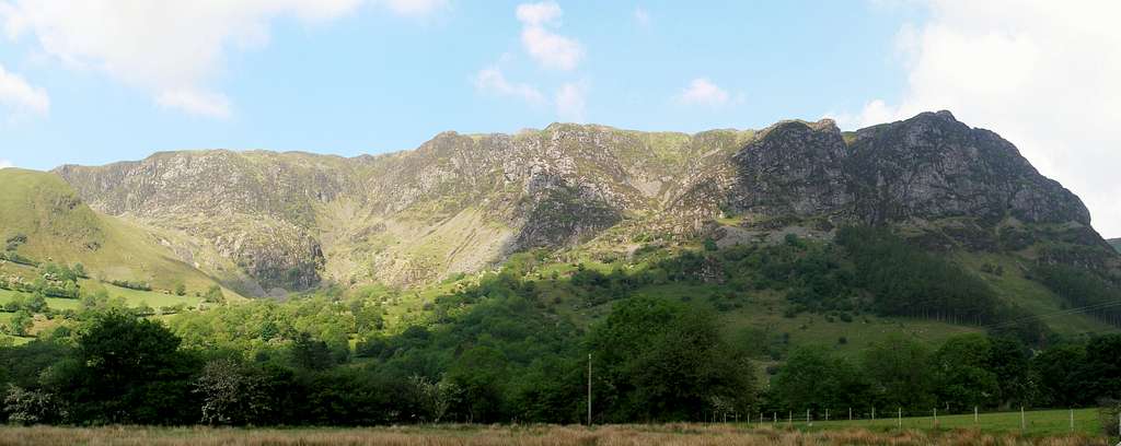
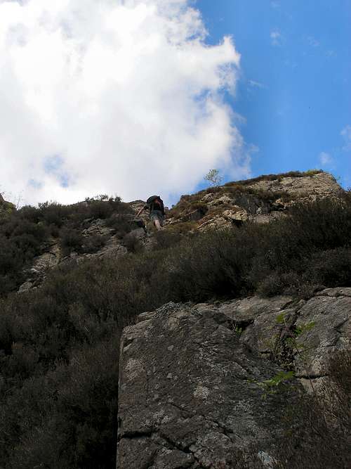
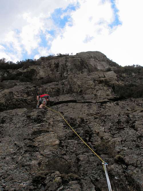
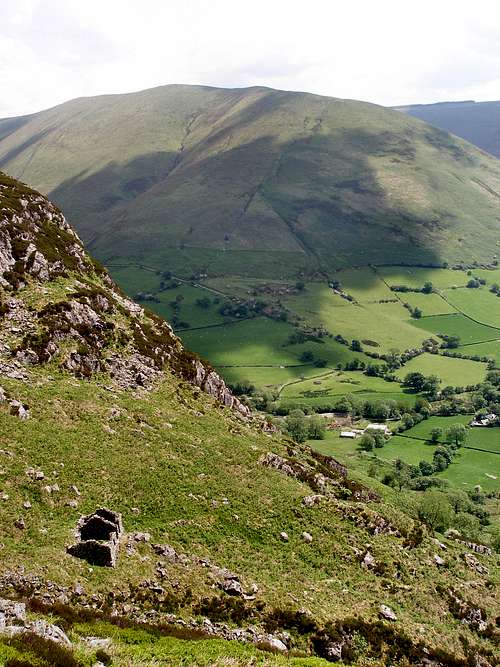
High up in the rarely visited southern wing of Craig Cywarch are a series of slabby rock-faces known collectively as Tap y Gigfran. The climbs here are wilder in nature than those in the north, they are harder to access, are more vegetated, and have trickier and less distinct descents. Jack of Diamonds (HVD, 105m, 5 pitches) is one of the best and most popular routes these slabs have to offer, and although plagued by a generous covering of moss, is definitely worth an ascent by anyone visiting this part of the crag. The route exploits an initial weakness near the base of the rock-face, and after 30m or so of ascent deviates sharply first to the right and then to the left over a series of exposed slabs. The climb has bags of atmosphere; its remote location and vegetative state make you a feel like a true pioneer. Furthermore there are a large number of single pitch routes on the surrounding crags, so if you have time there are plenty of opportunities to bag some extra climbs. All in all, this route has the potential to be an integral part to a very enjoyable, productive and worthwhile outing.

FA: M.H. Jahn and R.E. Kendal (Alternate Leads), September 22nd 1956.

Craig Cywarch
Craig Cywarch (Photo by Nanuls)

Getting There

To reach the trailhead turn off the A470, which runs between Dolgellau (SH 729 181) in the west and Machynlleth (SH 748 008) in the south-east, at Dinas Mawddwy (SH 858 148) and take the road towards Aber-Cywarch (SH 867 157). Just after you cross the bridge at Aber-Cywarch turn left up an unclassified road signposted for Cwm Cywarch. Follow the road, which is narrow and winding, until you reach the parking area at Fawnog Fawr (SH 854 182). The approach begins here.


Route Description

Approach

Leave the car-park at Fawnog Fawr via the track that heads west up the side of Y Gribyn. Follow the track past the farm at Gesail and keep following the track as it rises up the hillside. After a short while you will come to a sharp u-turn in the track, leave the track by climbing over a wire fence and cross a small marshy field which has a large boulder in it. Climb over the fence at the other side and begin to contour around the hillside under Tap Pant Cae. This will bring you to the South-Face of Tap y Gigfran. The climb is on the Eastern Face so you will need to go around the base of the crag before ascending the slope to the base of the climb. There are two options for this – the first is to ascend the heathery slope on the right hand side directly to the base of the crag. The second is an easy climb called Incapability (D) which leads up to the base of a neighbouring climb called The Gem (HS 4b), which Jack of Diamonds begins just to the right of. Incapability should pose few problems for an experienced and/or confident party and an ascent can be made without the need for placing protection.


Incapability
The Approach (Photo by Nanuls)
 
Jack of Diamonds
The Route (Photo by Nanuls)
 
The ruin below Tap y Gigfan
The Descent (Photo by Nanuls)

Route

Although the description for this route describes it in 5 pitches, it can be done in 2 or 3. Start the route in the middle of the rock face right of an obvious gully.

Pitch 1 (18m): Climb the short slab to a ledge below a steeper slab, and then climb it to a grassy ledge.

Pitch 2 (18m): Climb the undercut slab (it can be identified by a rusty old cam which is stuck in it), and follow the line of weakness diagonally up to a ledge on a steep wall. Traverse right and belay off the obvious spike.

Pitch 3 (24m): Climb diagonally left across the steep wall on good holds and over a slab to a ledge on the left wall. This is the crux of the climb.

Pitch 4 (30m): Climb easily over a broad slab to a heathery ledge.

Pitch 5 (15m): Scramble over broken rock to the top.

Descent

Descend via the small valley to the north of the climb. You’ll need to ascend a little to get around the large gully that splits the crag in two, but once your around it the route off the crag is easy.

Essential Gear

A single 60m rope will be fine (or you may want to use a double) a moderate rack of nuts, hexes and maybe a few cams. Also be sure to carry a selection of slings and screwgates for constructing belays. The route is best done in rock shoes as boots would be way too cumbersome. Naturally you will also need all the other paraphernalia associated with climbing and hill walking in Wales: full waterproofs, fleece, hat, gloves and of course some lunch.

Maps

Open Space Web-Map builder Code
Navigation Maps

Ordnance Suvey 1:25k Explorer Series OL 23 Cadair Idris & Bala Lake / Llyn Tegid

Ordnance Survey 1:50k Landranger Series 124 Porthmadog & Dolgellau

Harvey Map Services 1:25k Snowdonia Aran

Harvey Map Services/BMC 1:40k British Mountain Map Snowdonia South

Road Maps

Ordnance Survey Tour Series 10 North and Mid Wales

Guidebooks

Snowdonia (Official National Park Guide) Snowdonia (Official National Park Guide) by Merfyn Williams with contributions from Ian Mercer and Jeremy Moore

A handy book full of useful information and interesting facts about the National Park.
Climbers Club Guide Wales: Meirionnydd Climbers' Club Guide Wales: Meirionnydd by Martin Crocker, John Sumner, Terry Taylor, Elfyn Jones, with contributions from Mike Rosser, Mike Lewis and Dave Wrennall

The definitive climbing guide to the area. Contains detailed descriptions and excellent diagrams of all known routes on Craig Cywarch. An essential purchase if you plan to do a lot of climbing in Mid Wales.

External Links

Craig CywarchCraig Cywarch (Photo by Nanuls)
Tap y GigfranEastern Slabs of Tap y Gigfran (Photo by Nanuls)
Tap y GigfranSouth Face of Tap y Gigfran (Photo by Nanuls)
Glasgwm-Craig Cywarch CliffsCraig Cywarch (Photo by daveyboy)

Government Bodies and Official Organisations

Snowdonia National Park Authority

Council for National Parks

Association of National Park Authorities

Natural Resources Wales

CADW

Royal Commission on Ancient & Historical Monuments in Wales

Gwynedd Archaeological Trust

Snowdonia Society

The National Trust

Hiking, Climbing and Mountaineering Organisations and Companies

British Mountaineering Council

The Climbers’ Club

UKClimbing

Plas y Brenin National Mountain Centre

Snowdonia-Active.com

Hightreck Snowdonia

Weather

Mountain Weather Wales

Weather from the Met Office

BBC Weather

Tourist Information

Visit Wales

North Wales Tourism Partnership

Local Information from Gwynedd.com

Local Information from Snowdonia Wales Net

North Wales Index

Travel

Welsh Public Transport Information

UK Train Timetable

Accommodation

Youth Hostel Association in Wales

Pete's Eats

Pen-y-Gwryd Hotel

Maps and Guidebooks

Ordnance Survey

Harvey Map Services

Cicerone Guidebooks

Climbers’ Club Guidebooks

Rockfax

North Wales Bouldering

Cordee Travel and Adventure Sports Bookshop

Wildlife and Conservation

Joint Nature Conservation Committee

Natur Gwynedd

North Wales Wildlife Trust

Royal Society for the Protection of Birds


Parents 

Parents

Parents refers to a larger category under which an object falls. For example, theAconcagua mountain page has the 'Aconcagua Group' and the 'Seven Summits' asparents and is a parent itself to many routes, photos, and Trip Reports.