
|
|
Route |
|---|---|
|
|
45.93404°N / 7.27543°E |
|
|
Skiing |
|
|
Spring |
|
|
A few days |
|
|
BSA |
|
|
Overview
The Haute Route, between Mont Blanc and the Matterhorn, is the most coveted ski-mountaineering tour in the Alps, attracting people from all over the world. A summer route connecting Chamonix and Zermatt was originally charted by members of the Alpine Club in the mid 19th century and was dubbed the "High Level Road". By 1861 many of the notable Club members had walked the route. The first traverse on skis was undertaken in 1903 (or 1911 depending on itinerary) and the ski route, including the passage of Plateau du Couloir, became known as the classic "Haute Route". Even though the route is not too difficult, it should not be underestimated. Rope and crampons are likely be used at some point and, while route finding should not be a problem in good weather, in poor visibility it can be problematic. The best time for the ski tour is late March to May, when the huts open. The traverse can be completed in five days, but you could be forced to wait out bad weather at some hut, allow for extra days in your plan. The record for the traverse, from the church in Chamonix to the church in Zermatt, is 16 hours and 35 minutes set on 21 March 2016 by Bastien Fleury and Oliver Meynet via Col de la Grande Lui/La Fouly.Day 1
Argentiere 1200m - Grands Montets 3297m - Cabane du Trient 3170m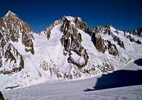
Col de Chardonnet from Grand Montets
 On Gl. d'Argentiere |  Col de Chardonnet |  Plateau du Trient |
Day 2
Cabane du Trient 3170m- Champex 1466mFrom the hut descend to the plateau du Trient and follow the right side of the glacier north. Reach a flat area of the glacier with an icefall to your left at about 3000m over a step of the glacier. Keep to the right and descend a steep slope/gully between the seracs to your left and the rocks on the right. Traverse right NE with a diagonal below the rock wall heading for the obvious notch of Col des Ecandiens 2796m reached with a short ascent on foot. At the col you stand at the top of the long and beautiful Val d'Arpette, with good snow a fine descent of about 1300m. Descend to the right side at first, and reach the small village of Arpette 1627m. Follow a piste down into the wood until you reach the road. Turn right E and reach Champex 1477m with a short walk.
 On Glacier du Trient,below the hut |  The passage on Gl.du Trient |  Col des Ecandiens |  Val d'Arpette |
At the first cafe` you find on the road it is possible call a taxi and arrange the transfer to Bourg-St-Pierre. A cheaper option is to take the bus from the center of Champex, a short distance further on, but you may have to wait and delay the ascent to the Valsorey hut too much. Ask for the bus schedule as soon as you can (or make a plan in advance) and decide the best option depending on the time you arrive in Champex. If you arrive in Champex late spend the night in Champex, Orsieres or Bourg-St-Pierre, as the ascent to the Valsorey hut is long (4hours) and can be unsafe in the afternoon heat.
Bourg-St-Pierre 1650m - Cabane de Valsorey 3030m
The trail-head to the Valsorey hut is on the main road (Orsieres Gr-St-Bernarde) and is sign posted. If you take a taxi the driver will drop you at the trail head, from Bourg-St-Pierre pass under the main road to gain the Valsorey valley. Follow the right bank of the Valsorey valley (to your left). With a long and slowly ascending track pass by Cordonna 1834m and reach a wide and flat area below Chalet d'Amont 2197m. On the right the path to the Velan hut crosses a bridge. Keep to your left until you enter a narrow gorge at about 2240m. Climb the gorge E until you reach easier grounds, turn NE to the Grand-Plans 2501m and head for the rock spur leading to the Valsorey hut. Climb right of the spur E a steep slope until it is possible to traverse left to the hut.
 Lower Valsorey valley |  Upper Valsorey Valley |  Valsorey hut |
Day 3
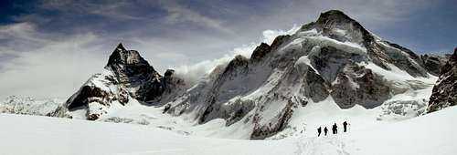
Cabane de Valsorey 3030m - Plateau du Couloir 3664m - Cabane de Chanrion 2462mFrom the hut climb NE toward the Grand Combin de Valsorey on moderate slopes at first. After 200-300m the slope becomes very steep and it may be difficult to proceed on skis if snow condition is less than perfect. Slant right E and aim for a point where the snow slope merges with the rocks of the Combin du Valsorey, left of the Col leading to Plateau du Couloir. Traverse right, just below the rocks, and gain the Plateau left of Point 3664m (Bivacco Musso, painted red, is perched on the top of this Point). The final traverse is quite exposed, and rocks and ice surface from the snow, it is best to proceed with rope, axe and crampons. From the Plateau descend SE on the upper Sonadon Glacier, do not descend too much, make an arch E-SE to reach Col du Sonadon 3504m with a short climb. From the col do not attempt a direct descent to the Glacier du Mont Durand, a serac wall bar the way. From the col you have two options: 1) descend SE and reach a terrace over the icefall, traverse right S to the lower rocks of the Grand Tete de By at 3400m, 2) traverse S and descend a steep slope to the lower rocks of the Grand Tete de By. Descend the right side of Glacier du Mont Durand passing near the rocks of Tete Blanche. Always keep on the right side of the glacier and keep going E and then SE to reach the rocks and the lateral moraine at about 2700-2800m. Start a slightly rising traverse to a plateau and cross the NE ridge of Mont Avril at the Point 2735m. Descend SE and then turn NE to reach the stream somewhere left of pt. 2207m. Cross the stream and start the final climb N passing by some chalets to reach the Chanrion hut 2462m.
 Route to Pl.du Couloir |  The traverse |  Routes from Col du Sonadon |
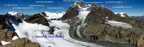
Summer view of the descent from Col du Sonadon on Gl. du Mont Durand
Day 4
Cabane de Chanrion 2462m - Pigne d'Arolla 3796m - Cabane des Vignettes 3160mThere are at least three options to reach the Cabane des Vignettes. The original route follows the Otemma Glacier all the way to Col de Chermotane. This is a boring haul up a long and flat glacier, with no downhill skiing, but this is also the shortest and safest option in case of bad weather. A second route follows the Glacier du Brenay directly to Col du Brenay, and over Pigne d'Arolla. This route pass a short steep section with possible avalanche risk between the lower rocks of La Serpentine and the icefall of the Glacier du Brenay. The third route is via Glacier du Brenay, Glacier de la Serpentine, Col de la Serpentine, Col du Brenay and over Pigne d'Arolla. This is the longest but is a good option to fill a fine day. Here follows the description of the third option.
From the hut go N traversing the lower slopes of P.te d'Otemma. When you reach the shoulder turn NE and cross the moraine near pt. 2624m. Traverse on a gently rising line and reach the glacier. Gradually move to the right side of the glacier (your left) toward the confluence of the Glacier de la Serpentine. Turn N and enter Glacier de la Serpentine keeping the crevassed and seracs area to your right. When you have passed the crevassed area move into the middle of the glacier and aim for Col de la Serpentine 3547m. From the col turn E. You should see the Pigne d'Arolla with its ice dome, but the iced shoulder of the NE ridge of la Serpentine is in the way. Go over the shoulder and descend SE to Col du Brenay 3639m. This traverse is not too steep but is exposed and ice usually surface, consider proceeding with axe and crampons. Climb NE the easy slope of Pigne d'Arolla to the col 3730m, and from here to the summit 3796m. Return to the col and enjoy the descent E on the wide slope to about 3300m at about the same level with a serac area to the left. From this point you have two options: 1) Traverse left E below the seracs by a narrow passage then turn left N, go over a ridge, Col des Vignettes, turn right E and reach the Cabane des Vignettes 3160m. 2) Descend the slope S toward Col de Chermotane, do not reach the col, drop only 150m and make turn NE, almost a U-turn. Traverse on a steep slope and reach a saddle leading shortly to Col des Vignettes and the hut. (There is a line, probably a water pipe, suspended over Col des Vignettes). The Vignettes hut is perched on a cliff high on the abyss below, you wont forget the airy traverse to the toilette.
 Gl. du Brenay |  Gl. de la Serpentine |  Passing the shoulder |  Pigne d'Arolla |
Day 5

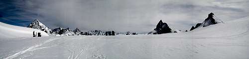
Cabane des Vignettes
Cabane des Vignettes 3160m - Col de Valpelline 3568m - Zermatt 1600m
From the hut go back to Col des Vignettes, go S toward the saddle and traverse on steep slope to Col de Chermotane 3053m.

View from Col de Chermotane
 Route to Col du Mont Brule` | 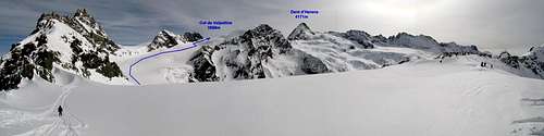 Route to Col de Valpelline |
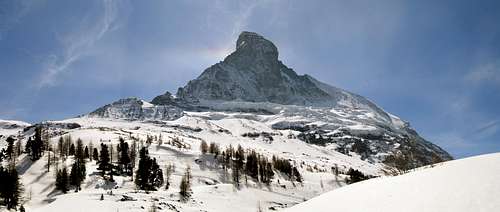
Reaching this col in good weather is the highlight of the tour. The pyramidal summit of the Dent d'Herens suddenly appears over the snow line, then the sharp summit of the Matterhorn shows up, and the faces of these giants slowly unveils. The view from Col de Valpelline is one of the best in the Alps and the descent to Zermatt is probably the most spectacular, the shining ice of the north face of Dent d'Herens and the severe west face of the Matterhorn will keep your attention for a long time down. But don't forget the crevasses, in bad visibility this descent can be a trap, there are icefalls and plenty of big crevasses along the way. In good visibility focusing on the route should be enough to avoid troubles.
Col de Valpelline
From the col ski the slopes of the Stockji Glacier NE. At about 3200m start a wide turn, SE at first then traverse a plateau S, the north face of the Dent d'Herens should be in front of you. The plateau ends over a steep slope with seracs on the right side. Descend the slope, keeping away from the seracs, to get to the Tiefmatten Glacier. At the end of the steep slope, at about 3000m turn left E, stay close to the rocks and away from the crevasses on your right. Continue on safer ground until about 2600m where you see the Zmutt glacier merging from the left. Now you have to cross the Zmutt glacier and move to its right side, go E toward the lower slopes of the north face of the Matterhorn. Make a long diagonal near the right lateral moraine until you see the road to your left at the bottom of the valley. Follow the road, connecting with a piste, to Furi, and from here to Zermatt by cableway or ski depending on the snow cover.
On the Stokji Gl.
 Passage to Tiefmatten Gl. |  Tiefmatten Gl. |  Looking back |
Below the Matterhorn
Variations
There are several variants to the classic route, the most popular is the Verbier variation, avoiding the main crux of Plateau du Couloir. The Grand Lui alternative avoids road transportation adding two days to complete the route.Verbier variant:
Day 2: Cabane du Trient - Champex - Verbier - Cabane du Mont Fort
Day 3: Cabane du Mont Fort -Col de la Chaux - Col de Severeu - La Barma - Cabane des Dix
Day 4: Cabane des Dix - Pigne d'Arolla - Cabane des Vignettes
Grand Lui variant
Day 2: Cabane du Trient - Fenetre de Saleina - Col de Saleina - La Fouly
Day 3: La Fouly - Fenetre de Ferret - Gr.St.Bernard Hospice
Day 4: Gr.St.Bernard Hospice - Col de Prox - Cabane de Valsorey
If you arrive in Chamonix too late to embarque for the traverse to Cabane du Trient, and you don't want to spend the night in town, an alternative plan is the following:
5 days +1/2 variant
Day 0: Argentiere - Grands Montets - Refuge d'Argentière
Day 1: Refuge d'Argentière - Champex
Day 2: Champex - Bourg-St-Pierre - Cabane de Valsorey
This plan also has the advantage of splitting the long day from Cabane du Trient to Cabane de Valsorey in two.
Maps
Almost all the route is coverd by two 1:50000 sheets of Carte Nationale de la Swiss (with ski routes): CNS 282S Martigny and CNS 283S Arolla.CNS 284S Mischabel covers the extension to Saas Fee.