

-
 14340 Hits
-
 93.04% Score
-
 41 Votes
|
|
Route |
|---|---|
|
|
45.32232°N / 116.5442°W |
|
|
Scrambling |
|
|
Spring, Summer, Fall |
|
|
Class 3 |
|
|
I |
|
|
 He Devil from the northeast showing major features. Enlarge for greater detail.
 Detail of lower ridge access.
Overview
The Northwest Ridge is the easiest route on He Devil; Class 2 most of the way with some Class 3 scrambling the last couple of hundred feet on the summit block.Low on the ridge, there are traces of a trail giving way to talus and boulder hopping higher up. The summit block consists of easy short cliffs and ledges.
Approach
 The Cross-Country route to Sheep Lake, and one approach to the NW Ridge.
Enlarge for greater detail.
For another topo with a slightly different approach see This image
The ridge can be accessed either from the Sheep Lake Trail (123) on the north or from He Devil Lake to the south.
He Devil Lake is a long ways in (about 10 to 12 miles from Windy Saddle). From there it is about another 1.25 miles and 2,000 vertical feet to the summit.
The Sheep Lake Trail (124 to 123) is 9 miles from Windy Saddle to Sheep Lake and about 8.5 miles to where it is left to access the Northwest Ridge. From there it is about another 1.25 miles and 1,000 vertical feet to the summit.
Using the High Route AKA Goat Pass Cross-Country Route to Sheep Lake, it is about 4.75 miles from Seven Devils Campground to the summit and it can be done very reasonably as a day climb from the car.
An alternative approach (from that on the main page) to the Cross-Country Route is to start directly from the campground. Take the right fork of the road in the campground. The trail starts from the first campsite after the second set of out houses. There are parking spots other than the campsite nearby.
The trail is very obvious and easy to follow. In a couple of places lower down it splits, but the forks come back together. From the campground to the pass is about 900 feet of vertical then about 600 feet down to Sheep Lake. From the lake to the summit is about 1,500 feet of vertical.
Once at the lake, the easiest way to the trail is around the south side of the lake. The trail is easy to find on the southwest side of the lake where it ends in several campsites.
Leave the Sheep Lake Trail (123) somewhere near the pass between Sheep Lake and Gem Lake and traverse south or climb up to the west depending on where you leave the trail and drop over the ridge into a small basin with a spring. From there, ramps lead onto a broad ridge that can be followed to the Northwest Ridge that is easily gained up a shallow couloir.
Route Description
Once on the ridge, follow traces of a trail until it is lost in talus and boulders. Continue up the ridge to where you can easily traverse to a small notch below the summit block. Scramble up easy low cliffs and ledges to the summit.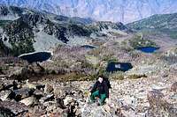 On the NW Ridge On the NW Ridge |
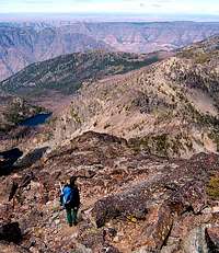 View down NW Ridge View down NW Ridge |
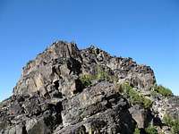 Summit Block Summit Block |