
-
 8826 Hits
-
 74.92% Score
-
 5 Votes
|
|
Route |
|---|---|
|
|
48.45330°N / 113.34343°W |
|
|
Mountaineering |
|
|
Spring, Summer, Fall |
|
|
A long day |
|
|
Class 4 |
|
|
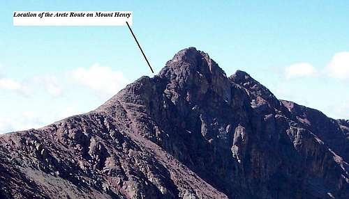
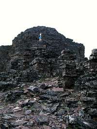
Overview of Mount Henry's Arete Route:
 The Arete.
Layout designed for best viewing on a "1024 x 768" screen.
“There is no way we can make it to the summit of that mountain….no way!”
These were the words echoing in my ears from my climbing partner who was on his first climbing trip in Glacier National Park. We set out early in the day from the Scenic Point trailhead and had just climbed a little over 3,800 feet, he was feeling beat up, sore and exhausted. Once again he said there is no way to get through the final cliffs to the summit.
 Triumph
“Wait and see, just wait and see.” I went on to tell him that many times the mountains in Glacier hold their secrets closely but generally they are quite willing to reveal them if we just explore a bit and are patient. (A good guidebook, map and personal experience helps a lot too.)
In the next half hour or so, my friend came to understand about passages through the rocks and stood in triumph with his arms raised in the air on the 8,847 foot summit of Mount Henry. He had just climbed his first major named peak in Glacier National Park.
In his guidebook, Edwards writes of the final approach to Mount Henry as “For the final fifty yards, the ridge narrows to a sharp arete. Either carefully climb along the top of the arete or descend 100 feet to the southeast and enter a gully that angles up to the summit of the mountain.”
The arete sounds exciting and inviting as well as a bit dangerous on paper. The first time on Mount Henry we opted for the “safe route” as my friend who had little climbing experience and prefered terra firma under both of his feet ALL the time. We did the proverbial scree slog up the gully after loosing about 75 feet of elevation. That route worked just fine and aided in arriving at the same summit that is achieved by climbing along the arete. However, there was a nagging question...should we have or could we have climbed along the arete?
The second time around would be different. We would climb the Arete.
 The route photographed from Medicine Peak.
An arête is a thin, almost knife-like, ridge of rock which is typically formed when two glaciers erode parallel U-shaped valleys. The arête is a thin ridge of rock that is left separating the two valleys.
Arêtes can also form when two glacial cirques erode headwards towards one another, although frequently this results in a saddle-shaped pass, called a col. The edge is then sharpened by freeze-thaw weathering.
The word "arête" is actually French for fishbone; similar features in the Alps are described with the German equivalent term Grat or Kamm (comb).
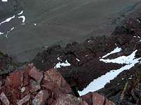 Looking down the North side of the Arete.
The Arete Route is amazing. To the right the Appistoki Creek Valley literally lies 1,800 feet below. One slip and the body will bounce a few times before landing on the permanent snowfields below Henry’s face. On the left a more moderate drop of 25 to 50 feet presents better options for living through a fall. There are great holds on that side of the arete; play it safe and stay on the left side!
History Side Note:
 |
|---|
Before World War II Mount Henry had a bell on its summit. The Glacier National Park website reports that:
During the latter part of August 1925, W. R. Mills, then advertising agent of the Great Northern Railway, and H. A. Noble, manager of the Glacier Park Hotel Company, made a request of the park superintendent for permission to place locomotive bells on the summits of the following passes in the park: Swiftcurrent, Logan, Siyeh, Gunsight, Cut Bank, Stoney Indian and at Grinnell Glacier. This request was based upon an old Swiss custom of having bells on the mountain tops and passes and the desire to give the visitors hiking or riding through the park the unusual experience of ringing these loud, clear bells high in the mountains.
The request was passed on to the office of the Director of the National Park Service, who did not approve of the idea but was somewhat loath to say so at the time, so the decision was postponed. Mr. Noble continued to press for the bells, and finally in September of 1926 the request was granted for at least two bells to be established in these passes. Within the next two months the company had placed three of them on Swiftcurrent, Piegan and Siyeh passes. These bells were bought by the Hotel Company at a cost of $194.27 each plus packing, shipping and the expense of placing them. They were very beautifully toned and created a considerable amount of interest among the people who crossed these passes and heard them ring.
A fourth bell was placed on Mt. Henry, where the Glacier Park-Two Medicine Trail crosses Scenic Point, high above Lower Two Medicine Lake, in the summer of 1929. The bells remained in place until the fall of 1943, when they were removed by the Hotel Company and turned in on a World War II scrap metal drive.”
Getting There:
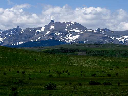 Mount Henry from Highway 2, Vantana Photo
An enjoyable day with incredible views into the Nyack area and Two Medicine Peaks!
This route is located in the Two Medicine Valley of Glacier National Park. See the Mount Henry main page for details on how to reach the trailhead.
The Scenic Point Ridge Walk according to J. Gordon Edwards is “a route that covers 13 miles of exhilarating open country.” The Scenic Point Ridge Walk crosses three Glacier Park Peaks which include Mt. Henry and Mount Appistoki as well as Medicine Mountain. See the map for the Scenic Point Ridge Walk.
| To visit Glacier National Park is to enter a place where Heaven touches Earth affording brief glimpses into the Wonders of Creation. |
Red Tape:
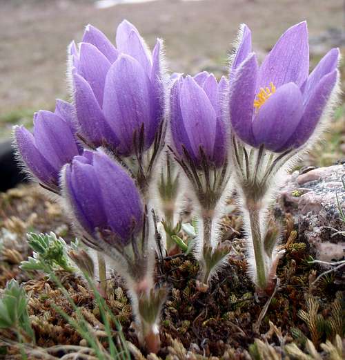 Pasqueflower, Angela V. photo.
CLIMB REGISTRATION: You do not have to register for day climbs in Glacier National Park but it is recommended. Backcountry travel regulations can be found at Backcountry Travel. There is also information from the Park Service on Mountain Climbing in Glacier.
As with all hiking and climbing in Glacier National Park use caution and practice good manners with the wildlife. You are in bear country. Carry bear deterrent spray, don’t hike alone and make some noise. For more information please go to the Park's website for Bear Information. The U.S. Forest Service also has helpful information on Grizzly Bear Management.
Vehicle single entry fee for Glacier National Park is $25.00 for 7 Days, $12.00 per person for single hiker, motor biker or bicyclist. An "America The Beautiful Federal Lands Recreational Pass" for goes for $80.00 which gives entrance to all National Parks, National Forests, BLM, US Fish & Wildlife, and Bureau of Reclamation sites for one year from date of purchase. See Plan Your Visit for other information regarding all of the National Park entrance fee information.
Route Overview:
The AreteGuidebook: A Climber’s Guide to Glacier National Park;
This trip is featured in Edwards’ “Routes Among The Peaks” on pages 315-316 in A Climber’s Guide to Glacier National Park. Edwards states in his guidebook that the trip should take about 10 hours. It also crosses unnamed peaks and allows access for other peaks in the area such as accessing Mt. Ellsworth on an extended spur route. Mount Henry sits at the head of Appistoki Creek and has an imposing face that rises over 1,700 feet above the valley floor. Total elevation gained from the trailhead is 3,867 to the summit of Mt. Henry.
Volume Two of Climb Glacier National Park has details on Mount Henry and suggested routes. It can be ordered at Climb Glacier National Park.
Special Considerations: The rock in Glacier Park is widely varied and it is not unusual to find several different types of rock on any given route. Know your rocks and be certain of your safety. J. Gordon Edwards has an excellent section in his guidebook on rock and climbing safety. Be safe and know your limitations as well as those who are climbing with you. Also refer to the following links for further details: GNP Rock and Grading System and the GMS Climbing Guidelines.
Route Description:
 Starting Views Class 4 Arete
 Starting Views Class 4 Arete
 Starting Views Class 4 Arete
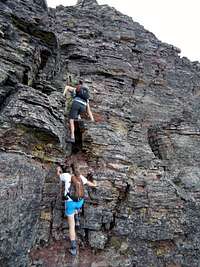 Class 3 Gully Climb
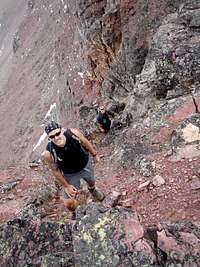 Class 3 Gully Climb
 Final Scramble
Follow the Scenic Point trail to its highest point at approximately 7,400 feet in elevation. From this point, walk along the east side of the point labeled on the map as 7643. from that location walk to the saddle below Medicine Peak and climb through the solid scree slopes to the dark red colored rocks (argillite) below Medicine Peak. Side hilling to the climber’s right is an effective way to gain elevation. Keep gaining that elevation and soon the summit cairn of Medicine will be seen of cliffs along the wall will force vertical scrambling. There is a U.S. Geological Survey marker located (on the Appistoki Valley side) about 3 feet from the cairn.
From Medicine Peak continue west along the ridge. Climbers can easily bypass the first few minor elevation annoyances along the ridge if desired. Within a short time climbers will be presented with the final false blockage which is most easily avoided all together by walking around its south side. Stay near the ridge and the platform to begin the Arete Route will be located. For those who prefer not to climb over the arete the scree gully awaits you! It is from this same platform that the gully route begins. See the Scenic Point Ridge Walk Route – Gully Route for more details.
The Arete Route involves some easy Class 4 climbing across the generally level arete. The route has solid hand and foot holds throughout the brief 40 foot wide crossing of the arete. After crossing the arete a Class 3 scramble through a “scree free” gully leads to the final shelf below the true summit. This is also the location where the gully scree route is rejoined.
There are a number of options to reach the actual summit from the shelf. None of them have to be more difficult than class 3. At the summit enjoy views into the Nyack area and up to Flinsch and Rising Wolf.
A PVC register is located in the summit cairn.
Options for descent include following the climber’s trail to the north and summiting the next unnamed peak labeled 8,650 on the map. Descending the ridge on goat and sheep trails to the north will lead to the saddle between Appistoki and this unnamed peak. Keep your eye out for the Pika that live in the scree slopes below Point 8,650.
If there is interest in climbing Appistoki please see the Appistoki Peak page. This page also shows possible return routes to the trailhead.
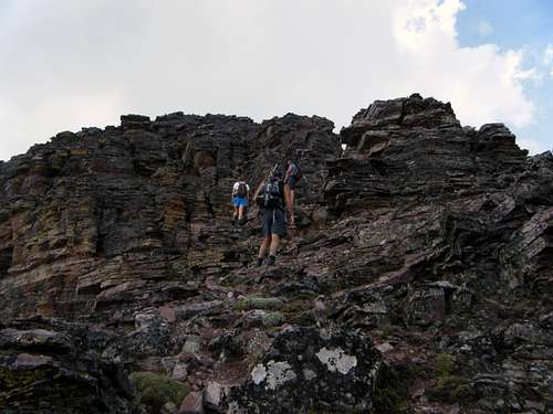 Final Scramble
When to Climb:
 June 15, 2009: Weather is rolling in...threatening an early end to the day in the mountains.
It would be possible to complete the Scenic Point Ridge Walk during most months of the year. When the route is snow free obviously depends upon how much snowfall the area gets. Spring as well as early summer snow fall (even as late as the middle of June) also is unpredictable and it would be best to have alternative routes and areas as a back-up. It would be necessary to ski/snowshoe to this route after the roads close. Roads in the Two Medicine area typically open by the first week of June. Click here for Glacier Park Road Status.
Obviously it will take more work to get to these peaks in the winter. Also know that it will take rescuers just as long so be prepared.
The arete route will be snow free before the gully route so if you climb early in the season expect to climb along the arete.
Weather:
Essential Gear and Guidebook:
There is some snow melt early in the climbing season but in the heat of summer this is a dry route until descending off of Appistoki so take water for the trip. Hiking poles and bear spray would be advisable as well.If an early season climb is made an ice axe and crampons may be helpfull when crossing or glissading down snowfields.
Volume Two of Climb Glacier National Park has details on Mount Henry and suggested routes. It can be ordered at Climb Glacier National Park.
A Climber’s Guide to Glacier National Park; J. Gordon Edwards