
|
|
Route |
|---|---|
|
|
52.84073°N / 3.99508°W |
|
|
Scrambling |
|
|
Spring, Summer, Fall, Winter |
|
|
Half a day |
|
|
Scrambling to Grade 3 but with much scope for variation |
|
|
Overview
Although the compact gritstone buttresses of the Rhinogydd offer plenty for the able rock climber, the discontinuous nature of their crags means that longer routes are few in number. This, combined with typically Spartan facets of said crags, means that long routes of an amenable grade are even fewer. There are however, maybe a handful of exceptions, and one such exception is the South Face of Rhinog Fawr. On first appearance this too appears too broken to yield anything of substance, but if you look for it, a perhaps somewhat artificial route can be made out by following a series of crags and boulders which rise from the narrowest point of Cwm Nantcol to the mountain’s western fore-summit. The route has the honour of being the range’s only true scramble, and weighs in at a respectable Grade 3. For the most part the scrambling is fairly sustained, and only really suffers when crossing the wide slabby plateau that links the lower tiers with the final push to the summit. This however, can be easily forgiven, as the spectacular landscape it places you in is unique to this part of Wales, perhaps even, to the world. The rock is of mostly excellent quality and benefits from the friction one would normally expect from a lithology of this type. Despite this, care should be taken in places, as loose stones and boulders may spell trouble for anyone below you. |


Getting There
The start of the approach is located in part of Coed-y-Brenin Forest at the Graigddu-Isaf (SH 680 300) car park on the eastern side of Rhinog Fawr. To get there turn off the A470 at a very small junction (SH 711 307) just south of Bronaber. The junction is small and easily missed, extenuated by the fact that the road has numerous similar small exits, is very straight, and consequently, very fast. On turning off you’ll be immediately greeted by a gate across the road, go through this making sure you close the gate behind you. Drive along the road for around 3km until it terminates at the car park, just inside the forest. |
Route Description
The Approach Rhinog Fach (left) and Rhinog Fawr (right) from the car park (Photo by Nanuls) Rhinog Fach (left) and Rhinog Fawr (right) from the car park (Photo by Nanuls)Leave the carpark along the forestry track that continues the natural course of the road westward. After a couple of minutes walking you will be diverted off the track along a wet, vegetated, and winding path through felled trees. The deepest gullies have had plastic pipes placed in them which can be used as ‘stepping stones’. Providing you manage to reach the other side without succumbing to the bog, you will exit onto a forestry track that fronts Graigddu-Isaf Farm (SH 680 300). Turn left and walk along the track in a southerly direction. After a few hundred metres, you will pass the junction for Bwlch Tyddiad. Here there is a sign post, one sign points up a small path to Bwlch Tyddiad and the Roman Steps, the other points along the track you are already on, towards Bwlch Drws Ardudwy and Cwm Nantcol. Continue along the track towards Bwlch Drws Ardudwy. After around a kilometre of walking you will reach a hairpin bend, which crosses a stream at its apex (SH 673 286). Just before the apex, a small path, which is notified by a yellow arrowed signpost used to denote public rights of way, leaves the track in a south-westerly direction. Exit the forestry track and follow the smaller path to the end of the forest (SH 670 285). Here the landscape opens up, with Rhinog Fach to your left and Rhinog Fawr to your right. Bwlch Drws Ardudwy lies directly before you. Continue along the path towards the apex of the col, which is marked by a medium sized cairn (SH 664 282); the route begins some 300 metres further on, where the pass is at its narrowest. There is a significant wall running along the southern side of the path, and the exact start of the route begins at where an indistinct ruined wall, which runs up towards Rhinog Fawr, meets this. The Route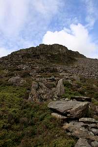 The start of the route (Photo by Nanuls) The start of the route (Photo by Nanuls)From your position at the wall junction you will now be able to see a series of tiered crags above you; it is these that the route climbs. Save yourself the arduous task of battling through heather by beginning the route on top of the remnants of the ruined wall which soon becomes lost in the boulder field above it. Work your way through the boulder field towards the first tier, again the boulders prove easier going than the heather around them. The boulders vary in size and shape, and micro scrambles can be found if you have time to play. The end of the boulder field is marked by a large boulder of around 3 metres height, which sits on a grassy terrace, and is backed by the steep crags of the First Tier. Make your way left, past the boulder to where the crag becomes more gradual and broken. Climb this to a small heather terrace and a large hanging block. Skirt around the block to the crags behind and climb a series of ledges up steep cracked walls to another wide heather terrace. The crags of the Second Tier are now directly in front of you. The most obvious feature of this section of crags is a large patch of ivy near its centre, to the right of which is a small tree. Below the small tree is the start of a rightward slanting break which cuts through the full length of the crag. Awkward moves up this will take you to the top of the crag and another heather terrace. An alternative to the break for the bold and the roped is a series of steep steps to its right. On this terrace stands the Third Tier of crags, which are split by an obvious gully just to the left of its highest section. Climb the steep rock to its left up steps to a ledge at about half height. Move rightwards below a steep wall, and where this ends, climb another few metres to another ledge. Sidle right to a recess and climb a slab to the right again, here the gradient eases, allowing you to survey the rest of the route.  The fore-summit The fore-summit(Photo by Nanuls) At the top of the third tier you will be greeted with a wide, and relatively level, eastward arching ridge. Much of this is covered by flat, clean slabs of rock, which provide a much easier approach to the next section of scrambling than the heather that occupies the remainder of the ridge. Ahead of you lies the fore-summit (SH 660 289) of Rhinog Fawr, an appealing mass of broken cragletts and boulders. The most obvious feature of this section is a large discontinuous gully that runs up its centre, with the rock to its left offering the most continuous scrambling. Climb the slabs, taking care in places, as loose rock on this section can prove a hazard. This section offers an almost unlimited number of variations and alternatives, giving the route high level of repeatability. Where the gully narrows and steepens, move right underneath it to a grassy terrace on the opposite side. Traverse around the base of the crag and ascend a leftward trending break to the top of the fore-summit. From here the summit proper of Rhinog Fawr (SH 656 290) is just a short walk away and is marked by that quintessential sign of a high point, the trig pillar.  Llyn Du (Photo by Nanuls) Llyn Du (Photo by Nanuls)The DescentA choice of descents now presents itself. The most natural continuation is to descend along the braided paths of Rhinog Fawr’s north-western flank to Llyn Du (SH 655 294), and then to make your way around the northern side of this to its outflow. Then follow a path that runs back down the mountain in a north-easterly direction to the forest. The forest is entered via a ‘kissing gate’ and an obvious, if occasionally boggy, path takes you back to the forestry track on which you began your journey. |


Essential Gear
The bold probably won't feel the need for a rope and all its associated paraphernalia, however if you do want to use such gear, a single 50m rope will be fine, a small rack of nuts and hexes, and a few slings and screwgates will suffice. The route can be done in mountain boots or rock shoes, although boots are probably more advantageous considering the broken nature of the climb. Naturally you will also need all the other bits and pieces normally associated with hill walking in Wales: full waterproofs, fleece, hat, gloves and of course some lunch. |
Maps
|
| Navigation Maps Ordnance Survey 1:25k Explorer Series OL 18 Harlech, Porthmadog & Bala/Y Bala Ordnance Survey 1:50k Landranger Series 124 Porthmadog & Dolgellau Harvey Map Services 1:25k Rhinogs/Rhinogydd Harvey Map Services/BMC 1:40k Snowdonia South Road Maps |
Guidebooks
|

External Links
 Rhinog Fach from Cwm Nantcol (Photo by Nanuls) Rhinog Fach from Cwm Nantcol (Photo by Nanuls) Cwm Nantcol (Photo by Nanuls) Cwm Nantcol (Photo by Nanuls)Government Bodies and Official Organisations Snowdonia National Park Authority Association of National Park Authorities Royal Commission on Ancient & Historical Monuments in Wales Hiking, Climbing and Mountaineering Organisations and Companies British Mountaineering Council Plas y Brenin National Mountain Centre Weather Tourist Information North Wales Tourism Partnership Local Information from Gwynedd.com Local Information from Snowdonia Wales Net Travel Welsh Public Transport Information Accommodation Youth Hostel Association in Wales Maps and Guidebooks Cordee Travel and Adventure Sports Bookshop Wildlife and Conservation |