
-
 6664 Hits
-
 96.51% Score
-
 60 Votes
|
|
Route |
|---|---|
|
|
41.91722°N / 111.6559°W |
|
|
Hiking, Scrambling |
|
|
Spring, Summer, Fall, Winter |
|
|
Half a day |
|
|
Class 2 |
|
|
Overview
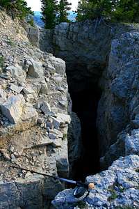 Southwest Ridge Sinkhole
The southwest ridge is the standard route to the summit of Mount Magog. It starts at Tony Grove Trailhead in Logan Canyon. The route follows a trail for a couple miles and then goes up the southwest ridge to the summit. This is one of the easier peaks in the Bear River Mountains thanks to the high elevation start from the trailhead. It is a fun and interesting mountain so I thought I should submit a page it. Despite its rugged appearance, the hike is only class 2 and there was a faint footpath on the ridge. When I climbed the peak many years ago, there was no evidence of this at all. So I guess more people have been climbing it. The view from the summit is really nice and there is a steep drop from its north face down toward the White Pine Lake cirque.
The name Magog comes from the Bible and so does Gog and Naomi. Bullen Hole Peak is unofficially named. It is sometimes referred to as Ezekiel Peak which is a name that comes from its relation to Gog and Magog in religion.
Distance is 4 miles to the summit via the southwest ridge with 1,800 feet elevation gain.
Getting There
Drive on I-15 north of Brigham City and take exit 362 (US-91/Logan). Keep driving on US-91 through Sardine Canyon. After 25 miles US-91 will merge into Main Street in Logan. Drive to the intersection of Main Street and 400 North in Logan. Turn east on Highway 89 into Logan Canyon. Drive for about 18 miles to the exit to Tony Grove. Turn here and follow this road for 7 miles to the trailhead and also the parking lot for Tony Grove Lake.
If coming from the northeast near the cities of Soda Springs or Montpelier in Idaho. Turn onto Highway 89 and drive south toward Garden City which is on the east side of the range near Bear Lake. Drive up the switchbacks into Logan Canyon. Go over the summit of the canyon and then drive to the road junction turnoff to Tony Grove. Drive up this road for 7 miles to the trailhead.
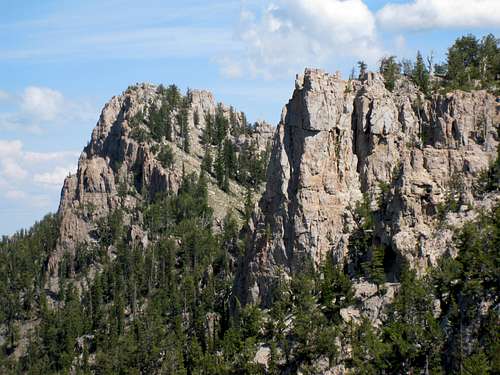 Mount Magog Southwest Ridge
Route Information
From Tony Grove trailhead, start hiking up the trail heading north. In about a quarter mile you will get to a junction. The trail to White Pine Lake goes right for 3.8 miles. The trail to Naomi Peak goes left for 3.3 miles. Take the trail that goes left. Follow this trail through meadows that are often filled with flowers during summer. You'll get a good view of Mount Magog here.
The trail gains elevation very gradually as it goes through the canyon. It then enters into a large valley beneath the east face of Naomi Peak. The trail goes toward the ridge that separates Naomi Peak from Mount Magog. This is where I left the trail : (N 41.91259 W 111.66788). Head toward the top of the ridge and start hiking along the southwest ridge of Mount Magog.
You will go over a sub-peak labeled as 9,614 elevation on maps. Near the top of this subpeak is a large sinkhole. It shows up all of the sudden so keep an eye out for it. If you are following the very top of the ridge you will run into a cliff. There are several gullies to the right that you can descend to get around it. You'll lose some elevation here before you go up the final part of the route.
The pyramid shaped summit can be seen to the northeast. Follow the ridge and hike on talus and grassy slopes up this steep face. You'll be able to see cliffs above so just hike up a gully to the left to avoid them. The summit may look difficult but it ends up being rather easy. It consist of several large limestone square and rectangular blocks. One is slightly higher than the others.
 Southwest Ridge Southwest Ridge |  Southwest Ridge Southwest Ridge | 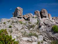 Magog Summit Magog Summit |
The Views
There are great views of the Bear River Range from the summit. To the south you can Tony Grove Lake and the trailhead. To the southwest is Naomi Peak. To the northwest is Bullen Hole Peak aka Ezekiel Peak which is higher than both Magog and Gog. Directly north is Mount Gog and below its south face is White Pine Lake. Farther behind Mount Gog to the north is Doubletop Mountain. From this vantage point the two mountains blend in with each other. To the northeast is Steam Mill Peak which looks like a small bump on the ridge from here. On a clear day you can see all the way to Sherman Peak in Idaho if you know where to look. The summit is surrounded by cliffs some of which are hundreds of feet high on its north face.
Descent
1) Most people will descend the ascent route from the Naomi Peak trail. You can easily combine both peaks for a nice day hike.
2) South Slope Descent: This is an optional descent down the canyon that is located south of Mount Magog. I found this route to be a little faster than following the ridge back down. A good landmark is a dry lake bed near 9,100 feet elevation. Descend down steep boulders and rocks. Once there, hike around the lake bed on either side to avoid boggy areas. Farther down the canyon you will get to another dry lake bed near 8,900 feet elevation. I saw deer in this area so there must be some water around here. Continue down canyon while losing 200 feet in the process. You should be able to see the trail on the other side of the hill now. It should be in this area : (N 41.90762 W 111.65331). From here, follow the trail all the way down to Tony Grove trailhead.
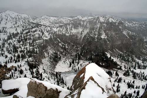 Mount Gog seen from Mount Magog - by bighornhunter
When to Climb
The main climbing season for Mount Magog is during the summer months. This is July through September.
The mountain can also be climbed in late spring and early fall depending on snow conditions. In normal years, snow last in early summer. Many people who have climbed nearby Naomi Peak in early July have encountered a lot of snow at the higher elevations. In fall, there are few people out hiking until October when hunting season takes place. Tony Grove can be accessed in winter by skiing or snowshoeing.
What to Bring
Hiking boots during summer and fall. Day pack with food and water. Ten essentials. Trekking poles. TopoMap.