
-
 11406 Hits
-
 85.29% Score
-
 20 Votes
|
|
Route |
|---|---|
|
|
42.84016°N / 0.20119°W |
|
|
Hiking |
|
|
Spring, Summer, Fall, Winter |
|
|
Most of a day |
|
|
easy but long hike |
|
|
Overview
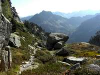
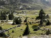
 Typical landscape on the lakes loop
If you want to explore the Vallée de Marcadau region thoroughly in one day, I recommend the “Circuit des Lacs”, the lakes loop.
The lakes loop is an easy day hike through the whole Vallée de Marcadau from Pont d´Espagne - the trailhead - to the french mountain club hut Réfuge Wallon - Marcadau. The alpinistic part of this loop is the trail to the lakes d`Embarrat, du Pourtet and Nère, six beautiful lakes in a beautiful and interesting mountain landscape.
Vallée de Marcadau is situated southwest of the town of Cauterets. South of Cauterets, the main valley Gave de Cauterets divides into Vallée de Lutour and Val de Jeret. The latter leads up to Pont d´Espagne and to another valley bifurcation: Vallée de Gaube and Vallée de Marcadau.
Vallée de Marcadau is limitated by the Massif de Gaube to the east and the ridge between La Cardinquère and Pic de Péguère to the west and northwest. The next valley to the west is Val d´Estaign.
Pine woods are shading the lower slopes of the Vallée. Granite peaks, gras and scree summits surround those lakes. If you are a strong hiker you may summit one of the easier peaks alongside the trail: Pic Arrouy, Soum de Bassia, La Habassole, Mont Aigu or La Cardinquère west summit. The first and the last three need some climbing work (UIAA grade I / II). But also without a summit in the pocket the lakes loop is a great hike in the Hautes Pyrénées.
Getting There
 A morning near Pont d´Espagne in Vallée de Marcadau
The trailhead for the lakes loop is at Cauterets - Pont d´Espagne.
Follow D 920 from Argelès-Gazost to Cauterets and D 920 to Pont d´Espagne with the huge parking area (fee required).
Route Description
From the parking area follow the road to the west, which leads up to the famous waterfalls and a mountain inn. There is a foot trail right of the road which, too, arrives at the mountain inn right in front of the cascades.
 Routes Overview Routes Overview | 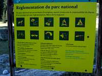 What to do and not to do What to do and not to do | 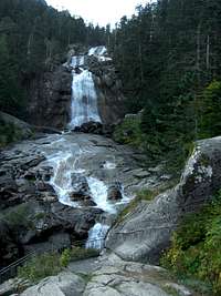 The famous waterfalls of Pont d´Espagne The famous waterfalls of Pont d´Espagne |
At the mountain inn there is the junction with the trail leading up to Lac de Gaube and to the Réfuge des Oulettes de Gaube below huge Vignemale. There is a cablecar, too, which shortens the ascent to the beautiful Lac de Gaube.
For the lakes loop take the right hand road which soon enters the meadows of Vallée de Marcadau. At Chalet Réfuge du Clot you have the choice:
Both routes meet at Pont de Cayan, where the nearly level part of the valley ends and there is a slope leading to the upper part of Vallée de Marcadau.
For the lakes loop, follow the signposts “Circuit des Lacs” and take the right hand trail which steeply climbs the slopes of Coste de Castet Abarca. The trail zigzags up the pine woods giving from time to time nice views into the Vallée, to the adjacent Massif de Gaube and – at one switchback – a view to a cascade in a steep rock chute, a very impressive sight.
 The trail at the Lacs d´Embarrat region The trail at the Lacs d´Embarrat region |  The trail at the Lacs d´Embarrat region The trail at the Lacs d´Embarrat region | 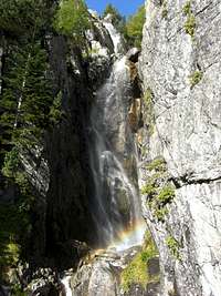 Beautiful waterfall below Lacs d´Embarrat Beautiful waterfall below Lacs d´Embarrat |
After a long traverse to the north and then to the west the route passes by the Lacs de l`Embarrat, two beautiful mountain lakes in a even more beautiful mountain scenery. The trail ascends steadily up the valley of the Lacs de l`Embarrat, passing by some more little lakes and arriving at last at the highest point of the loop: Lac du Pourtet, a marvellous mountain lake at a hight of 2420 m and with some interesting summits to climb: Pic Arrouy, Soum de Bassia or for those who love the rock climb: La Habassole, Mont Aigu or La Cardinquère west summit.
It is hard to leave this magic place but there will be other beautiful parts of the lakes loop still waiting for you. The trail passes Lac du Pourtet on its east shore and starts to descend to the south. Soon you arrive at the valley of Lac Nère and you pass the lake on its east shore. From the slope above Lac Nère there is a off – trail route to the slightly higher Lac de Bassia and to Pic de Bernat-Barrau.
 Glacier polished rocks Glacier polished rocks | 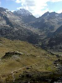 Vignemale as seen from below Lac Nère Vignemale as seen from below Lac Nère |  Peaks of the upper Vallée de Marcadau Peaks of the upper Vallée de Marcadau |
The trail continues to descend into the valley between La Cardinquère in the east and Pic de Bernat-Barrau and Tuc de Bassia to the west and arrives at the vast and beautiful meadows of Pé – dèt – Malh with great views into the high valleys around Réfuge Wallon – Marcadau: the valley to Col de Cambalès, to Col de la Fache, to Port du Marcadau and to the Col d´Arratille. Pic de Cambalès, Pene d´Aragon, Grand Fache, the Pics d´Arratille and, above all, the noth faces of Vignemale are dominating the scenery.
Soon you are standing in front of the huge Réfuge Wallon which is situated above Gave du Marcadau in nice green meadows between huge glacier polished rocks.
The last part of the lakes loop is the trail down Vallée de Marcadau from the Réfuge first on the orographic left side of the Gave de Marcadau, leading through pine woods in some ups and downs. Then the trail crosses the river, changes into a rocky and bad forest road and descends to Pont de Cayan. Choose your way – road or trail – to Réfuge du Clot and return to Pont d´Espagne parking area.
 Vignemale Vignemale |  Lac du Pourtet and Lac Nère Lac du Pourtet and Lac Nère | 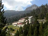 Réfuge Wallon - Marcadau Réfuge Wallon - Marcadau |
Routes Condition & Essential Gear
 Mont Aigu near Lac du Pourtet
Routes Condition, Gear
The Lakes Loop is a late spring to mid autumn (depending on the weather and amount of snow) hike for strong hikers.
Full hiking gear for a long day hike and good boots are sufficient.
It is, as I learned from SP-User visentin, a winter and spring (ski) hike, too. The best winter summit should be Soum de Bassia.
Maps
The following maps can be recommended:
Carte de Randonnées, 1 : 50.000,
Pyrénées, Carte No. 3, Béarn
Institut Géographique National, Rando éditions
IGN Carte 1 : 25.000
Number 1647 OT, Vignemale, Ossau - Arrens - Cauterets
(very good topo map)
Accomodations
 La Grande Fache as seen from the lakes loop near Réfuge Wallon
You find all kinds of accomodations in the surrounding villages:
Nearby villages are:
The following adjacent mountain hut provide food and lodging: