
|
|
Route |
|---|---|
|
|
45.54783°N / 25.22260°E |
|
|
Scrambling |
|
|
Spring, Summer, Fall |
|
|
Less than two hours |
|
|
Class 3 |
|
|
1B (Romanian grade), UIAA I |
|
|
Overview
 Overview
Window gully (Valcelul cu fereastra)
Window gully is the name of a very beautiful and popular route in the NW side of Piatra Craiului Mountains. It is the most direct line between Cioranga Mare ledge and the north ridge.
The name of the route was inspired by the natural arch carved in the stone and detached from the nearby ridge. This arcade allows access from Window gully to Smirdar gully (Valcelul cu Smirdar).
This is mainly a scrambling route and requires basic climbing skills for the obstacles present on the gully. No marking is present.
Route starts from Cioranga Mare ledge (close to the refuge with the same name) and continues on three different gullies: Window gully, Smirdar gully and the upper part of Cioranga Mare Canyon which has its origins below the North Ridge.
The difficult parts are present only along Window gully, summing up 140 m difference in altitude. Route duration: 2-3 hours. Approach from Cabana Plaiul Foii: 2 hours. A few words about Romanian (FRAE) Climbing Grades - here.
Getting There
Zarnesti city (730 m) is situated at 28 km from Brasov. Access from Brasov can be done via railway, bus or car (DN73/E574 then DN73A road). Because of his position and various transportation options, Zarnesti remains the best starting point to Piatra Craiului Mountains.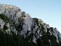 The rock paradise seen from Cioranga Mare.
From Zarnesti follow the country road to Plaiul Foii.
Usually, the Window gully is approached from Plaiul Foii via an unmarked trail. Other approach option could be: Ascutit peak (2150 m, on the North Ridge) – descend Cioranga Mare ledge – Cioranga Mare refuge. This variant is graded 1A (Russian grades ) and is also unmarked. Cioranga Mare refuge is also known as Sperantelor refuge or Cabana Ascunsa (Hidden hut - old wooden refuge not existing any more).
 Route topo.
Plaiul Foii – Cioranga Mare refuge
The path to Cioranga Mare refuge it’s not marked, but can be found with appropriate description and it’s clearly visible once the forest line is reached correctly.
From cabana Plaiul Foii cross Barsa Mare river on the bridge. Then turn to the left (east) and walk parallel to Barsa Mare, on the road. After 250 meters you’ll find a stream. Here the path leaves the road and heads up on a trail up the hill contour (no marking). From this place, the trail, less pronounced, keeps right (south), crossing a meadow. Gradually, the trail goes to the south (right), towards the imposing walls of the mountain. In this area the path follows a country road. Continue hiking up following the trail, then pass near a stream (1010 m) and follow its course. The trail bear away from the stream at some point entering a pine forest. A nice clearing follows, then you’ll soon find yourself at the base of Malul Galben’s scree. 50-60 m up and right on the scree you’ll find Orlovski spring. During hot season it might be dry. This spring is the only water source from this point up, so don’t miss the chance to refuel. Malul Galben (1270 m) is a big rock step that blocks the access further on.
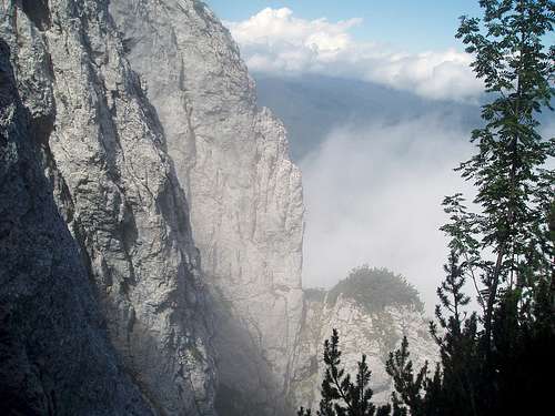 View from the middle part of the route.
The trail becomes steeper and continues through the scree. After 10 minutes from the spring it reaches a gully which is bearing left and up the rock wall (1380 m). From this point there are two options: bear left and follow the mentioned gully, or turn right and continue following the trail, at the base of the wall, until it ends. Usually the second variant is more frequented (and recommended), so I will describe this one. Both variants join together above Malul Galben rock step.
From the point where the trail ends, a steep wall blocks the access. Start to climb diagonally right on loose rock. The rock is not vertical and the short climbing section is not difficult. Continue up between trees, then a short traverse to the left comes. A cable is placed at this point as this portion is exposed and requires attention. After the left traverse, the trail continues sinuous through the woods until it reaches a col. Here the variant one joins (1540 m). The difficult part of the approach route is now finished.
Further on, the trail is visible and continues sustained upward. Passes by some rock formations and climbs small obstacles on its way. A more exposed one was secured with a cable. After some meanders through rocks and scree it reaches the lower part of Peretele Rachitei (Rachitei’s wall), hardly visible above the trees.
Here the trail splits: to the left Cioranga Mare refuge and the ledge with the same name, to the right Padina lui Calinet. Choose the left option and after 75 m you’ll reach Cioranga Mare refuge (1685 m).
Note: the refuge is basic and in poor condition but there are a few options for placing a tent nearby.
Route Description
Route starts from Cioranga Mare ledge, 60 m from the refuge, in the north direction. Leave the ledge when the first gully is met on the right side and start walking up the scree. The "window" which gives the name of the route.
After 30 m, the first rock step raises in front. It’s pretty high and overhanging and should be climbed on its right side. Mountain pines branches can be helpful here.
Continue scrambling up on the gully, climb other three obstacles (up to 12 m high), leave behind Rachitei ledge (Braul Rachitei) - which can be identified to the right - and you’ll reach then “the window”. Note that entire route is marked with stones until the north ridge.
Pass through window’s arch in the nearby (left) gully, called Smirdar gully, and advance through its scree until reaching the Upper Ledge (Braul de Sus). Smirdar gully has its origins here. To the right its “Amvonul” (the Pulpit) from where great views are opening in all directions: the whole area of Padina lui Calinet starting from the north ridge till Barsei valley, Muchia dintre Timbale, Coarnele Caprei ridge and the whole paradise of rock walls around.
To arrive on the north ridge, the route first follows the Upper Ledge to the left (north), passes through Portita Acului de la Amvon (Pulpit Needle – the needle is just a sharp stone important for orientation), and then descends into a third gully. This is actually the upper part of Cioranga Mare Canyon. From this point the route leaves the Upper Ledge and continues up on Cioranga Mare Canyon. The north ridge is then reached at a point situated between Timbalul Mare peak and Ascutit peak.
 The upper part of Cioranga Mare Canyon. My dear friend Morar Nicolae is trying to become part of the landscape.
Following the ridge to the left (north), guided by red dot marking, you’ll quickly reach Ascutit peak refuge.
Here you can choose between the following options:
● return to Plaiul Foii via Cioranga Mare ledge – Orlovsky spring (unmarked, grade 1A, easy scrambling)
● return to Plaiul Foii through Padina Popii – Diana (marked trail)
● descent to Curmatura hut and Zarnesti (marked trail)
● descend via the ascent route
Essential Gear
20 m ropeMap / Books
Map
◊ “Piatra Craiului / Piatra Craiului Mountains” tourist map. Guiding text in Romanian and English, scale 1:30000, edition Bel Alpin 2005. Can be bought from here.
Books
◊ “Piatra Craiului” by Emilian Cristea, 1984 edition (Romanian only, not published anymore). Contains detailed routes description and topos.
◊ “Trasee alpine in Carpati” by Walter Kargel, 1976 edition (Romanian only, not published anymore). Contains routes description and topos.
◊ “Drumuri spre culmi” by Walter Kargel, edition 1980 (Romanian only, not published anymore). Contains routes description and topos.
Small dictionary
Valcelul - gullyBraul - ledge
Smirdar – rhododendron
Varful – peak
Cabana - hut