
-
 3531 Hits
-
 76.66% Score
-
 7 Votes
|
|
Route |
|---|---|
|
|
48.13185°N / 121.57894°W |
|
|
Scrambling |
|
|
Spring, Summer, Fall, Winter |
|
|
Half a day |
|
|
Class 3 |
|
|
Short but strenous |
|
|
Overview
Well this is the route to the summit of Helena Peak via the southeast ridge approach.The trailhead is located at the end of the Deer Creek Road. You can park at the Kelcema Lake Trailhead, walk about 50’ up the road and you will see the trailhead on the left.
 Trailhead
This is or used to be the old Deer Creek Pass Trail. It’s in good shape right now, but it will only stay that way if people continue to donate their time to brush out the trail. The trail starts out kind of marshy with boulders resembling an old creek bed. Eventually you will enter into more of a forest. Follow the main trail for about 1 mile.
It’s at about 1 mile you will take a right on the Helena Mines trail.
 Take a right on this trail
It currently is flagged with orange ribbon. Once you take the right you will see a sign about 50' up the trail that reads, "Helena Mines". It is important to keep your eyes open for this intersection.

This trail is well flagged, but it is a rugged, faint trail. It has just recently been brushed out, but if it has a couple years of no attention it will become hard to follow. This goes through the forest on a traverse that skirts around a ridge. Eventually you come around the ridge and traverse more until the trail open up into a talus field. If you search around you will find a worn down trail that cuts through the talus. The trail crosses the talus field at a small gaining angle. You then go back into the bushes and start to climb up on a series of switchbacks. At this point you can see the cliffs to your right on the south ridge. In time you will get on top of that ridge, but obviously not yet. Continue up and soon it flattens out in a traverse until you get to the lower mine at about 4,500’.
The mine area is in some open timber with flat, Duffy areas. You can find the mine by seeing the red colored pile of tailings. The color should stand out. You should also see an old, rusty wheel leaning on a tree. These are all signs that the trail is finished and the route finding begins.
 Wagon Wheel
From here you basically go up. You can switchback through the open forest or choose the talus to your right. Either way the plan is to go up and gain the saddle at about 4,900’. Once you start getting closer you will see that there are basically 2 saddles with a rock outcropping between. You can go left or right here. We felt that going right was safer. If you go left it looks like this Going Left . If you plan on doing it you want to get just to the left of me where the greem moss is in the notch of the gully. I turned back because the moss was slick and you can see how steep it is.
 Below The Saddle
Going right you will ascend steep duff and bushy trees until you reach the saddle. Pretty easy. Once on the saddle you can look down a loose east gully. Looking up toward the rocky outcropping you want to traverse right on a ledge over to the trees.
 Route From Saddle
The trees will appear as though you can’t fit through, but it is possible. Once through the small, tight hole in the trees you will pop out on the other side with really nowhere to go but up. Go up on some loose rocks, narrow ledges and rotten branches. Be careful in checking the integrity of the rocks here. Some of them are loose. It’s about a 30 feet climb and then you are on the upper east portion of the ridge. The whole goal here is to get on top of this south ridge and head north on it. However, you will find that most your time will be spent on the east side of this ridge. Sometimes you might even choose to drop down lower on the east side just to feel safer from some of the exposure. From the saddle to the summit it is a series of class 2 and 3. You use your hands most of the 500’ scramble.
Stay along the climber’s right of the ridge and continue north. Soon you will come to the false summit that blocks access on the ridge.
 Skirting Around False Summit
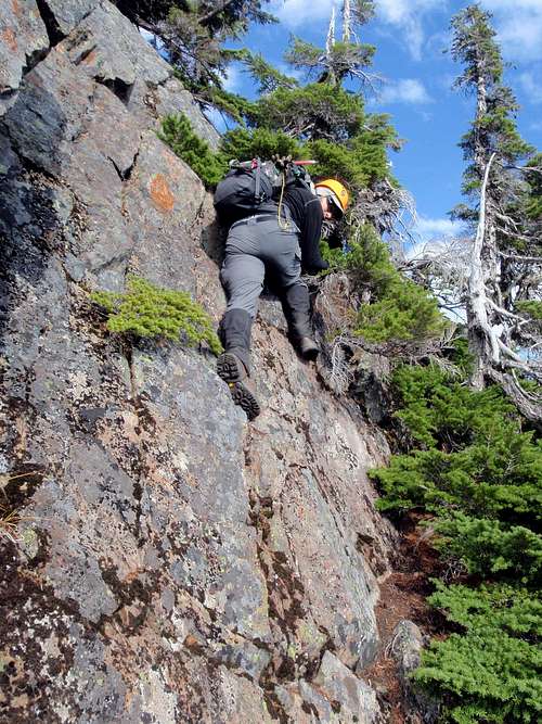 8' vertical wall
Go as far as you can until you get a good look at the headwall. Then look to your right downhill about 100’. There will be a ledge that skirts below the headwall to the right and it terminates into some scrub trees. There is also an old snag. Climb about 8’ of rock steps in front of you to get onto this ledge. Then walk the ledge to the old snag. From here you have to climb the vertical, smooth wall. There is exposure here and you have to make some big reaches to get up. Once up you wrap around the corner and you are on a downsloping ledge. When you walk the ledge the headwall of the false summit will be on your left. This goes for about 30’ until you come to an 8’ cliff. This might be the hardest move on the trip. This spot is physical, exposed but really the easiest way. Any other option is class 4. I turned myself around, faced into it and found a couple good holds so I could drop down to a small, angled, gravelly ledge. It’s a pretty awkward spot with a steep gully right below you. I did find some good holds, however there are also some real bad holds here as well.
Once past this it’s the same focus. At this point you are a ways below the ridge to the west. We stayed low here and did a traverse on steep pine needles. Soon we found a good line to get back up to the ridge. To get back up to the ridge you have to navigate a series of steep ramps. They are all pretty sticky and provide good traction. Its not to far after this you can see you summit block and the dirty gully.
From a ways away the dirty gully looks really bad. Once you get to the toe of it you will see that it’s a challenge but not all that bad. We stayed to the climber’s right ascending the gully. The rock on the right is more solid. I will say that it is very steep up the gully so be careful. There is also potential to release a large rock on someone below.
 Final Gully
The gully basically dies about 10 feet below the summit. You should be able to take it from there. The register is under a couple rocks in a Gatorade bottle. It’s a small, airy summit so be careful. The west face is very steep. Even to the point that I wouldn’t go out to take a peek. There looked to be some unstable rock with a huge drop.