
|
|
Route |
|---|---|
|
|
40.24940°N / 105.6414°W |
|
|
off-trail hiking with scrambing |
|
|
A long day |
|
|
Class 2 |
|
|
Approach
The Sandbeach Lake Trailhead is found off of Highway 7 near the Wild Basin ranger Station of Rocky Mountain National Park (RMNP).
Route Description
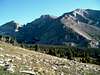
This route is probably the easiest way to reach the 3rd highest peak in RMNP. However, the elevation gain of this route for a single peak hike is among the greatest found in the park (5,267 ft). The trail to Sandbeach lake is 4.5 miles and is well worn with use. You will pass by many wooded campsites with limited to no views of the surrounding mountains. Once Sandbeach lake is reached, make your way along the right shoreline (north) and follow one of many faint paths that will take you up and through more forested area. You may walk across a small boulderfield with cars sized rocks to bound depending on which path you take. Countinuing north-northwest, the trees give way to a grassy and steep hill which means that you've reached the slopes of Mt. Orton . When the summit of Orton comes into view you make ask why bother climbing the 100ft. "pile of rocks?" Here's why: the top of Mt. Orton provides a central position between Wild Basin and the Front Range. Awesome views of Meeker, Longs, and Pagoda to the north and east. Copeland Mt. is the massive mound to the southwest and a perfect profile of Mt. Alice is seen to the west. You also get an idea of the terrain that is the entire rest of the hike to Chief's Head. Chief's Head appears to be smaller than Pagoda because it's peak is further from you. The rest of the hike to Chief's Head looks like a long and shallow descent until the apparently mild ascent to the peak. It's terrain reminded me of a wheel chair excessable ramp for a Greek god. This "ramp" turns out to be a 2000 ft+ elevation gain with an incline that provides many false summits . On my ascent, snow was not much of a problem even near the peak and the rocks where mostly large and immobile. There are a few areas of unavoidable small scree to challenge any hiker. I needed to head west along the ridge between Chief's Head peak and Pagoda before reaching the summit and register. The summit provides excellent views of Black, Green, and Italy lakes to the north. On a clear day you can see clear across the park to the Mummy Range. An ariel view of the Spearhead is another bonus of this peak. The return trip is the same unless you want to climb over to the west and descend past Snowbank and the Lion Lakes. This will add at least 2 miles to the total journey though. It is surprisingly only 2.5 miles from Sandbeach Lake to Chief's Head peak but takes many hours to reach. I believe this hike is no more than 14.5 miles roundtrip unless a detour to other more solitary alpine lakes is desired.
 |  |  |  |  |
Essential Gear
All you need is a map and compass plus whatever else will make a 14 mile hike (much above treeline) more comfortable.
Miscellaneous Info
If you have information about this route that doesn't pertain to any of the other sections, please add it here.
djilk - Aug 21, 2011 7:55 pm - Hasn't voted
Advice for hikersThe ridge between Chiefs Head and Pagoda is not a hiking route. The top of the ridge is intensely exposed, and getting up to it seemed to have some unavoidable class 3 moves. I descended 30-50 feet from the ridgeline to bring it to class 2+, but it was slow going. I descended via the westmost ridge (away from its exposed west side) and this was MUCH better. There is an occasional step or two of scree on this line, but it's a walking route. For those who do not like exposure, the summit ridge is wide enough (at least 30 feet at minimum) to avoid the cliffs, and the summit high point is NOT on the edge.