
|
|
Route |
|---|---|
|
|
40.47948°N / 111.76213°W |
|
|
Hiking |
|
|
Summer |
|
|
A long day |
|
|
Strenous Hiking |
|
|
Overview
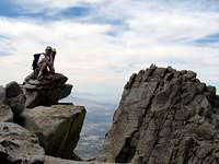
On the South Summit of Lone Peak, with the North Summit in the Background
Lone Peak, of the Lone Peak Wilderness, sits just south of the line between Salt Lake and Utah counties, making it one of the so called "Seven Peaks" of Utah County. This mountain has three peaks all of which are composed of gray granite, and are very jagged making Lone Peak unlike any mountain in Utah. The three summits form a cirque with a sheer 600 foot plus high face. On the summits climbers are treated with amazing views of Utah Lake to the south, the Salt Lake Valley to the north, Snowbird Ski Resort to the east, and Bingham Canyon Copper Mine to the west, as well as numerous mountain peaks in all directions.
Starting in Alpine Utah, and following the School House Springs trail, as outline below, requires over 6000 vertical feet of climbing and about 5 miles one-way to reach the peaks. In the summer and fall months most climbers will need to allow 10-12 hours to complete the full up and down climb.
Getting There
To get to the School House Springs trailhead from I-15, take the Alpine/Highland Exit and turn onto UT-92 heading east. Take a left at 5300 West (Alpine Highway). The name will change to Main Street. Take a right on Pioneer Road (600 North) and merge with Grove Drive. Grove Drive makes a sharp, 90 degree turn to the right following which you'll turn left onto Alpine Cove Drive. Finally, turn left onto Aspen Drive which ends at a locked and gated rough dirt road. Park here. Parking is very limited, only enough for one or two cars.
School House Springs Route Description

Summits of Lone Peak as seen from Pfeifferhorn to the east
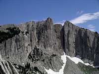
North and South Summits of Lone Peak a as seen from the cirque on the west side
From the parking spot (approximately 5,200 ft. elevation), climb through the brown colored metal gate and follow the dirt road north; you will come to a water tank shortly, and another gate. The second gate has a Lehi marker on it, pass through the gate and continue. After 1.5 miles or so, and several switchbacks, you will come to a third gate; this one is white, walk around it and continue up the road. Shortly you will see a fence marked PRIVATE PROPERTY, just stay on the road which switches back to the right at this point. At this point you are very close to the first hamongog (aka meadow), and have gained about 1900 ft.
As you walk up the dirt road from the parking spot to the first hamongog don't be tempted to take any shortcuts. Some maps mark a straight up short cut that cause you to bypass the private property sign mentioned above, avoid that shortcut as it will take you much longer.
It will take you around an hour to reach the Lone Peak Wilderness area from the parking spot. When you reach the first hamongog you will see the sign for the Lone Peak Wilderness, here the dirt road ends. The now single track trail veers left into the trees, and climbs steadily for roughly a mile and 1,000 vertical feet to the second hamongog where you will notice a trail intersection. Do not go right as that goes to Hardy Lake, instead go straight and cross the creek.
Pay attention now to the south face of Lone Peak that you will see to the north. Notice the two creek beds descending the south face (as displayed in this picture). Soon you will notice a light trail that goes straight up in a northerly direction toward the west peak and parallels the left most dry creek bed. Follow this trail, which is occasionally marked by cairns.
As you gain altitude the light trail eventually fades away as the terrain changes from shrubs and grass to small granite boulders. About 1,000 feet from the ridge between the west and south peaks you will pass through a field of large, whitish-gray, granite boulders. Route find through the boulders, the are widely spaced, in a north easterly direction as you continue ascending to the ridge between the west and south peaks. At this point you will not be able to see the north nor the south peaks, so aim for the ridge, and plan to make your way up in sort of a backwards C shaped trail so that you end up arriving at the ridge heading west.
When you make it to the base of the west peak you will notice the south and north summits above the sheer granite faces and the 600 plus foot drop into the cirque. Likely it will take you a couple of hours or more from the second hamongog, to reach this point. I suggest you go ahead and climb the west peak and take in the views of the other two peaks as well as the cirque from that vantage point.
From the west peak, I suggest, you next wander up to the south peak, which will take you about 45 minutes. Note that the highest point is the north peak, across a short class 3 ridge from the south peak. All in all, from the parking spot, it is likely going to take you 5-6 hours, minimum, to bag all three peaks, at which point your hike is only half done!
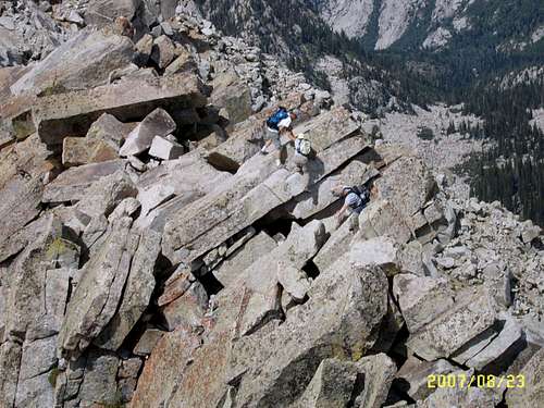 Class 3 Scramble between the South and North Peaks of Lone Peak Mountain
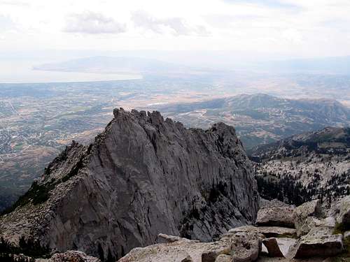 A view of the "west" peak of Lone Peak, as seen from the "south" peak.Notice the community of Traverse Mountain below.
Essential Gear
In the summer months all you need is a good pair of shoes, and lots of water (at least 5 liters per person). As you leave the second Hamongog going up, you might notice a spring in the trees just before you cross the creek. At the spring you can refresh your water bottles.
External Links
School House Springs Trail Map
Pictures
ambrose13 - May 29, 2013 8:27 pm - Hasn't voted
trailheadThe first gate at the dirt road was removed a few years ago thanks to the UWAF. You can now drive to the 'Lehi' gate and park near the water tank where a parking area has been cleared.