
-
 5014 Hits
-
 74.01% Score
-
 4 Votes
|
|
Route |
|---|---|
|
|
46.60740°N / 12.88070°E |
|
|
Download GPX » View Route on Map |
|
|
Hiking, Scrambling, Via Ferrata |
|
|
Summer, Fall |
|
|
Medium hard hike T4/T3 |
|
|
Overview
Wolayer Pass from Sentiero Spinotti
Bouquet
The value of this path lies in the following key points:
1. As an option for summiting Hohe Warte / Monte Coglians. But this is a good option only for those, who are trekking along the main crest of Carnic Alps in the west-east direction (so, not returning back to Wolayer See). To all others, who go only on the summit and down, Sentiero Spinotti is less convenient. If coming from the south, it goes much around, if coming from the Austrian side, you must use it also for the return.
2. As a descent option. The two marked routes over the northern wall are both very demanding, so Sentiero Spinotti is an almost exclusive option to get back on the Austrian side, after climbing one of them. It can be used also in combination with the normal south ascent (from Rif. Marinelli), when encircling the whole mountain group - for example from Ploecken Pass / Passo di Monte Croce Carnico.
3. As the connection between the two huts by Wolayer See and the Marinelli hut. A typical tour, done by the visitors from the Italian side, who don't attempt summiting Hohe Warte / Monte Coglians, is: Rif. Tolazzi - Sentiero dei Cramars - Wolayer See - Sentiero Spinotti - Rif. Marinelli - Rif. Tolazzi.
General Information
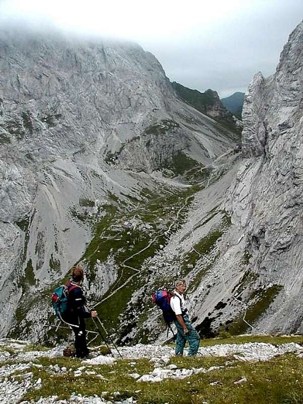
Orientation: The path is all the time well marked (No. 145). When in the broad south ravine of Hohe Warte / Monte Coglians (Valle del Ploto), from this path other marked paths deter left up, towards the summits. Depending on your intentions either use them for summiting, or continue by Sentiero Spinotti till the Marinelli hut. See the GPX track in the header!
Exposition: Sentiero Spinotti is quite exposed and so not appropriate for hikers who suffer from vertigo.
Objective dangers: When moving across the western face of Costone Stella, there is a considerable danger of rock fall. Also other people on the path can trigger lose rocks. In early summer, some route sections can still be covered by steep snow fields.
Best season: Summer and autumn months, normally from July till October (or first snow).
Gear: Good shoes, poles and eventually a helmet. For less experienced a ferrata set.
Tour start: See the main page of Hohe Warte / Monte Coglians how to get to Wolayer See, or Rif. Lambertenghi Romanin, 1955 m.
Highest point: 2780 m (if ascending Hohe Warte / Monte Coglians) or 2200 m (Costone Stella) and then 2122 m - Rif. Marinelli.
Altitude to overcome: Ca 950 m (if ascending Hohe Warte / Monte Coglians), otherwise 300 m (only Sentiero Spinotto).
Time for ascent: 3 h 30 min (if ascending Hohe Warte / Monte Coglians), otherwise from Rif. Lambertenghi Romanin to Rif. Marinelli good 1 h 30 min.
Route Description
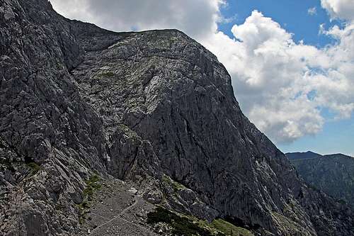
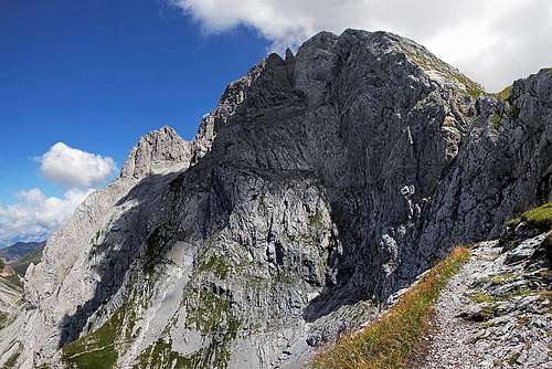
Sentiero Spinotti goes over this face
The upper part of the crossing
The main ascent of Sentiero Spinotti is however not finished yet. The path crosses the slopes again, enters a shallow valley and again ascends close to the west walls of Costone Stella. There a few wooden steps help you over a place, which is in winter swept by avalanches. Finally the path crosses comfortably right and up, on the beautiful, grassy balcony, where Costone Stella ends. We are on 2200 m.
The continuation goes by a broad terrace around Costone Stella towards the east. The path is easy, but also loses some 30 m of altitude. When entering Valle del Ploto, the normal ascent path deters left. For Marinelli hut we continue eastwards and then soon towards the southeast, staying on the same altitude. A comfortable path crosses the western slopes of Piz Chiadin and so reaches the hut.
The ascent on Hohe Warte / Monte Coglians is described on the page of the Normal South Route. If deterring from Sentiero Spinotti, you simply continue by Valle del Ploto up. The path is well marked, at first not at all difficult, but quite steep and due to soft scree slopes unpleasant. Soon from the right the upper path from Rif. Marinelli joins, then the direction turns a bit into the northwest direction. In the upper part of the valley, the path climbs over a rocky barrier, almost reaches the notch 2556 m, between the summit of Coston di Stella, 2607 m, and the main summit, but below it turns right and ascends the scree slopes almost till below the notch in the main ridge. There it turns left to climb the last 120 m of summit rocks. The route is marked, but not protected and requires some easy climbing up to UIAA I degree.
 Rushing - where to? |  Below the summit |