
-
 4387 Hits
-
 74.92% Score
-
 5 Votes
|
|
Route |
|---|---|
|
|
35.85000°N / 115.509°W |
|
|
Hiking |
|
|
Half a day |
|
|
Overview
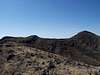
This is a nice gentle route up to the summit of Shenandoah Peak. There is not a lot of vegetation you find while hiking some desert peaks, bush wacking is minimal if at all along this route. This route covers 1.82 miles to the summit with about 1,120 feet of elevation gain. Elevation Profile
Getting There
From Las Vegas drive south on I-15 to exit 12 at Jean. Turn East towards Good Springs.Drive for 6.8 miles to a stop sign at Esmeralda. Turn Right.
Drive 0.2 miles (7.0 total) to Pacific, turn left.
Drive on this main road, which has a curve after about a half mile. After 2.7 miles (10.7 total) there is a fork in the road. Take the left fork.
Drive another 1.2 miles (11.9 total) and then turn left on a dirt road, drive less than 100 yards and you will see a place to park in front of the ridge straight in front of you. You don’t need to continue up the road any further.
Waypoints
Waypoint Lat LongWPT 1 35°52'08.0"N, 115°30'22.1"W
WPT 2 35°51'58.3"N, 115°30'24.6"W
WPT 3 35°51'44.6"N, 115°30'40.3"W
WPT 4 35°51'39.4"N, 115°30'43.7"W
WPT 5 35°51'31.9"N, 115°30'41.6"W
WPT 6 35°51'25.8"N, 115°30'47.7"W
WPT 7 35°51'19.4"N, 115°30'38.2"W
WPT 8 35°51'00.4"N, 115°30'34.5"W
Descriptions
WPT 1 Park 4774 feetWPT 2 On top of a ridge, turn South up this ridge. 4900feet; 0.2 miles
WPT 3 Hiking up a faint road up the ridge, after getting up this ridge you will see the landmark at waypoint 4. 5180 feet; 0.6 miles
WPT 4 Microwave tower, hike straight South up the ridge from this tower, then contour and stay on this ridge to the big ridge you see South of you, don’t go east into the valleys at all. 5330 ft
WPT 5 On the ridge, contour on the ridge that heads Southeast. You’ll see a tower on a point up on the ridge, use this as a benchmark.
WPT 6 On the main ridge heading east, you can see Shenandoah Peak to your SE. 1.1 miles; 5660 ft
WPT 7 At the big tower on a false peak.
WPT 8 Summit of Shenandoah Peak; 5864 feet; 1.82 miles
 |  |  |  |  |
Route Description
Refer to the Waypoints above for some specificsFrom your vehicle head straight up the ridge in front of you. After 0.2 miles you’ll be at WPT 2. Head slightly SW up the ridge from here. Eventually you reach WPT 3 which is up along a faint road that the ridge leads you up the ridge. When you get up on this ridge you will see a big Microwave Tower (WPT 4). From the tower hike straight south up the ridge and head towards the rocky ridge along this ridge. Hike over this ridge and then contour around this ridge up to the main ridge that heads southeast. A good Marker is the big tower you see above on the false peak (WPT 7).
When you get up on this ridge heading southeast toward the big tower you will see Shenandoah Peak off to the SE. Follow this ridge past the big tower and it eventually curves straight south up to Shenandoah Peak.
To return retrace your steps.
 GPS Trace
K9H2OBearer - Jul 3, 2012 12:15 am - Voted 9/10
Microwave Tower goneThe microwave tower has been removed and an admirable job of site restoration done. If you didn't know where it had been, you wouldn't know it was ever there.