
|
|
Mountain/Rock |
|---|---|
|
|
40.24900°N / 105.604°W |
|
|
Hiking, Mountaineering, Scrambling |
|
|
Spring, Summer, Fall |
|
|
13911 ft / 4240 m |
|
|
Under New Ownership
I picked up this page at Kane's recent fire sale. Thanks for turning this wonderful mountain's page over to me, Kane.
Mount Meeker Overview
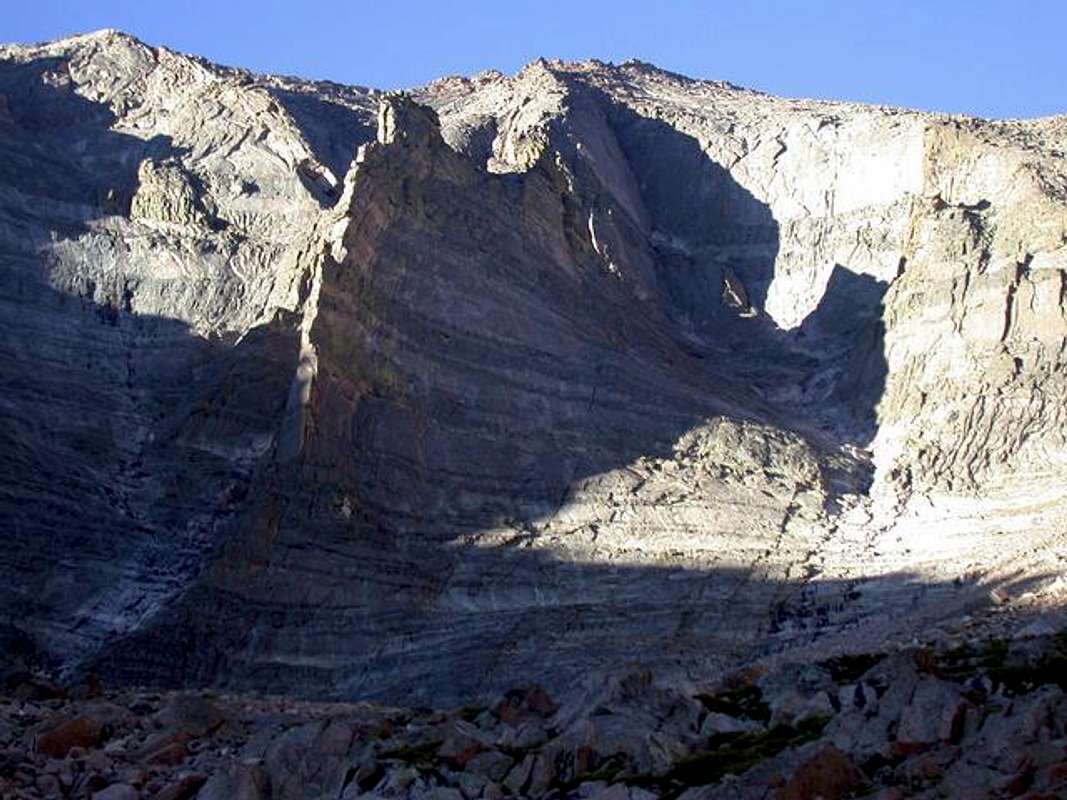
Photo credit Big G
The spectacular Longs Peak (14,255-ft.), Mount Meeker (13,911 ft.) glacial mountain cirque, has inspired hundreds of thousands of mountaineers all over the world. Mount Meeker is actually just a continuation of Longs enormous east face. In between, the Ships Prow (13,340-ft.) separates the two mighty peaks. Most believe Longs to be the undisputed monarch of all Colorado 14,000-ft. mountains, and there are those who believe Mount Meeker to be the king of Colorado's high centennial (13,800+ ft.) peaks. Combining the two offers a myriad of climbing possibilities, but Meeker alone has challenged many world-class climbers.
Mount Meeker rests .75 mile southeast of Longs Peak, and is the second highest peak in the Rocky Mountain National Park. Meeker has long west, south and east ridges that extend out from its tiny, exposed, pinpoint summit. These long, sweeping ridges consist mostly of large talus, and slabby cliffs, which make for mostly class 2 hiking until you reach a skinny summit ridge. There is a catch, if you keep the route mostly class 2 from one of these sweeping ridges, you have to deal with much more elevation gain (up to 5,671 ft.), plus the exposed section of the summit ridge is longer. In addition, good weather is a must, for you will be exposed to the elements on these high ridges for most of your day. In contrast to these sweeping ridges, Meeker has a huge, imposing, concave north face. The enormity of this steep face is apparent when viewing the standard Loft Route from Chasm Meadows. As the case with many other complex mountains, Meeker's daunting north face has its weakness, and attaining the Loft (13,460-ft.) between Longs and Meeker is doable by an interesting and scenic class 3 route. Depending on your experience, distance (11.4 miles), elevation gain (4,511 ft.), route finding, and exposure could be an issue.
This is truly a great hike, but I wouldn't recommend it to someone who doesn't have much bouldering/mountaineering experience. Too many things could possibly go wrong for someone who doesn't give this mountain proper respect. I usually don't post stuff like this on my pages but Meeker is starting to become a popular hike along with Longs. Typically, just the sight of Longs and Meeker will be enough to persuade some into rethinking their objective. I think I share the same view as many experienced hikers that we too often see people who are not properly prepared for a long climb of this sort, especially in this area.
 |
 |
 |
 |
 |
Meeker's Dreamweaver Couloir
Located on Mount Meeker's huge concave north face, the Dream Weaver Couloir is considered by many to be one of Colorado's premier spring snow routes. In between Meeker's East Arete and the spectacular Flying Buttress the couloir is easy to identify from the Chasm Lake area. The couloir starts on the right (east) side of the Flying Buttress and continues above the Flying Buttress to within 300 ft. of Meeker's summit (per Gerry Roach).
- Route Description
- Dream Weaver Thread
- Dream Weaver Trip Report per fourteenerworld.com
![]()
![]()
![]()
![]()
![]()
Longs Peak TH
You can reach the Longs Peak Trailhead from either the north or the south. If you are approaching from the north, measure from the junction of U.S 36 and Hwy 7. Go 9.2 miles south to a well-signed "Longs Peak Trailhead" and continue about another mile up the paved road to the trailhead. If you are approaching from the south, measure from the junction of Hwy 72 and Hwy 7. Go 10.5 miles north on the peak to peak Hwy 7 road to the well-signed "Longs Peak Trailhead." Continue another mile up the paved road until you reach a large parking lot. This is the most popular trailhead in Colorado, thus arriving at the trailhead between 4:00 a.m. and 6:00 a.m. is a must. Most spend the night just to get a spot in the parking lot. I arrived on a Sat. morning at 6:00 a.m. and had to park almost a half-mile away. Parking is free, for now.
![]()
Camping
There is camping at the trailhead but reservations are an absolute must. At this time I do not know what the cost is and what the usual wait is for a spot. If anyone has this info, please let me know and I will gladly add it. If you are interested in backpacking in a ways, there is a turn-off about 1.5 miles up the trail, it is called "Goblins Forest" and I noticed some camping in there. You must have an overnight permit for camping in Rocky Mountain National Park. You can probably attain a permit at the ranger station at the turnoff to the trailhead, but then again I could be wrong.
Author: marcminish
Date: Sept 06, 2002 11:06 AM
Overnight camping is also available at the Battle Campground located just inside the treeline on the east side of the mountain. There are numerous places to pitch a tent here with a very good watersource just a five minute walk away. Even in winter, the stream will still be running even if you have to punch a hole in the ice to get to the water.
Mountain Conditions
As usual for Colorado, conditions can range from the beautiful sunny high pressure in summer to howling, white-out blizzards in the winter. Or, the other way around!
The biggest weather hazard are the afternoon thunderstorms which can build with alarming speed and danger. These are common from May through September. The Front Range is also known for ferocious wind, especially in winter.
Longs Peak Ranger Station forecast, elevation 9420 feet, according to the National Weather Service. Of course specific mountain conditions vary wildly over small distances
Estes Park forecast, the gateway town on the east side of RMNP.
Weather charts data from the Niwot Ridge Meteorological site, located at at 3528m (11,572 ft) on Niwot Ridge, some 30 miles south of RMNP. This gives you an indication of recent regional high altitude conditions.
Colorado Avalanche Information Center, more mountain forecasts and current conditions, highly useful avalance information, operates in winter months only.
External Links


hgrapid - May 16, 2004 4:40 pm - Hasn't voted
Untitled CommentMount Meeker may have been named after Nathan Meeker, a New York newspaper editor who founded the town of Greeley, and was subsequently killed by Ute Indians based on a dispute. I am sure google might have more information, if you are interested.