

|
|
Mountain/Rock |
|---|---|
|
|
37.14251°N / 118.53053°W |
|
|
Inyo |
|
|
13525 ft / 4122 m |
|
|
Overview
I inherited this page from pilz8 in November 2011 and wanted to thank him for creating the page and giving me the chance to build on it.
Cloudripper is the highest peak of the Inconsolable Range, a small subrange north of the Palisades and just outside Kings Canyon National Park in the Sierra Nevada. Rising to just over 13,500 feet, Cloudripper also ranks as the 58th highest in California and is included on the Sierra Club’s Sierra Peaks Section SPS List. One of the most accessible 13ers in California, there are several class 2 or 3 approach and route options, and trips to Cloudripper can be completed as moderate dayhikes involving as little as seven miles round trip and less than 4000 feet elevation gain. Overnight outings are popular as well, with multiple alpine lakes and meadows surrounding the peak in every direction.
The views from Cloudripper are stunning, especially of the Palisade region. The vista includes notable points such as Mount Sill, North Palisade, Mount Agassiz, the Palisade Glacier, Mount Goode, Mount Goddard, Mount Darwin, Mount Humphreys, White Mountain, and many more. Trips to Cloudripper can easily be combined with a stop at Chocolate Peak, Vagabond Peak, or Sky Haven, and if on an overnight trip there are countless other possibilities.
 |
 |
 |
 |
 |
 |
Getting There

Route Map
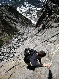
West Chute
The two most commonly used trailheads for trips to Cloudripper are from either South Lake or Glacier Lodge (North Fork Big Pine Creek). Both trailheads are in Inyo National Forest.
South Lake Trailhead (37.16928° N, 118.56568° W)
Turn west off Highway 395 in Bishop onto Highway 168 (W Line Street) towards Lake Sabrina. Follow Highway 168 for 15 miles to the well marked intersection with South Lake Road. Follow the road to South Lake for 7 miles to the parking area at the end of the road.
Glacier Lodge (37.12545° N, 118.43714° W)
Turn west off Highway 395 in Big Pine onto Glacier Lodge Road (W Crocker Street) and follow it 10.5 miles directly to the trailhead parking area at the end. There is a small lot for day use, but if full or going on an overnight trip you'll need to use the backpackers' lot 3/4 mile down the road.
Route Overview
There are several possible route options for trips to Cloudripper, all of them very scenic and with plenty of water sources and overnight camping possibilities. Please see the individual route pages identified here for additional information.
| Route | Trailhead (Quota Area) | Difficulty | Distance (one way) | Elevation Gain |
|---|---|---|---|---|
| North Slope via Green Lake | South Lake (Baker and Green Lakes) | Class 2 | 5.0 miles | 4200 feet + 600 feet on return |
| East Ridge via Seventh Lake | Glacier Lodge (Big Pine North Fork) | Class 2 | 8.6 miles | 6000 feet + 200 feet on return |
| East Ridge via Baker Lakes | Baker Lake (Baker and Green Lakes) | Class 2 | 3.5 miles | 3200 feet + negligible gain on return |
| West Chute via Chocolate Lakes | South Lake (Bishop Pass) | Class 3 | 3.5 miles | 3600 feet + negligible gain on return |
Red Tape
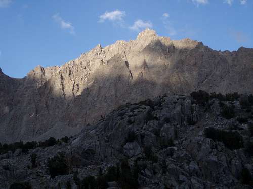
Sunset on Cloudripper
Wilderness Permits:
The route to Cloudripper is on Inyo National Forest land. No permits are required for day trips but overnight trips require one throughout the year. Permits for can be picked up at the White Mountain Ranger Station in Bishop or any other Inyo National Forest office. Quotas are in place May 1 through November 1. Check the Inyo National Forest wilderness permit website for the most current information and reservation availability.
Food Storage:
Bear canisters are not required but proper food storage is important.
Campfires:
Fires are prohibited above 10,400 feet within the John Muir Wilderness boundary.
Inyo National Forest Wilderness Permit Office
351 Pacu Lane, Suite 200
Bishop, CA 93514
Wilderness Information Line: (760) 873-2485
Permit Reservation Line: (760) 873-2483
Current Conditions
Current NOAA / National Weather Service Forecast
When To Climb
Spring through fall is the normal season, however winter ascents and ski tours are possible, as the approach is quite moderate. Contact Inyo National Forest in the off season for road conditions.
 |
 |
 |
 |
 |
 |
Camping
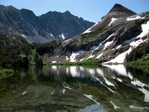
Cloudripper and Bull Lake
Though Cloudripper is a moderate trip for most to do in a day it is also a popular overnight destination. There are scenic alpine lakes encountered on every route, all making excellent overnight destinations. Some of the great options include Bull Lake, Green Lake, Thunder and Lightning Lake, any of the Big Pine Lakes, and several others.
If completing a daytrip, dispersed camping is allowed in Inyo National Forest, including a handful of areas along or just off Highway 168 from Bishop to South Lake. Even better, there are literally hundreds of roadside camping options in Buttermilk Country, located off Buttermilk Road (north of Highway 168). There are outstanding views of Mount Humphreys, Basin Mountain, Mount Tom, and White Mountain Peak from throughout the area.
Established campgrounds are abundant along the road to South Lake and in the immediate vicinity of both the South Lake and Glacier Lodge trailheads. There are also additional options nearby further up Highway 168 en route to Lake Sabrina. See the Inyo National Forest Campground Camping page for details.
Etymology
"The name first appeared in The Climbers Guide, and was added to the map by the USGS because it was in common use. On the Mt. Goddard 15' quad it is 1.1 miles east by south from Chocolate Peak, marked '13501.'” – Peter Browning, Place Names of the Sierra Nevada (2004)