
-
 251203 Hits
-
 99.9% Score
-
 160 Votes
|
|
Mountain/Rock |
|---|---|
|
|
47.07453°N / 12.69389°E |
|
|
12460 ft / 3798 m |
|
|
I. Overview
geographical classification: Eastern Alps > Hohe Tauern > Glockner Group > Grossglockner
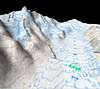
areal view of the Hohe Tauern king
The Grossglockner (original spelling: "Großglockner") is a mountain of superlatives, for non europeans probably the best known in the eastern alps. It is not the highest mountain in eastern alps (this is Piz Bernina (4049 m), and also Ortler (3905 m) and some other mountains there are higher), but these are in Switzerland or close to the border and the Grossglockner is some 180 km (110 miles) east of them. As the eastern alps are bigger than the western alps you can say that it is the "king" of the eastern half of the alps. When you order the mountains of the alps according to their prominence (that is the elevation over the deepest pass that separates it from the next higher mountain) Grossglockner is with a elevation of 2,423m over Brenner pass #2 of the Alps behind Montblanc.
The Grossglockner is the highest mountain of Austria and of course of the surrounding Glockner Group that is a central part of the Hohe Tauern Range. The summit is on the border of the provinces ("Bundeslaender") of Tyrol (the isolated eastern part and excluding South Tyrol which belongs to Italy since 1919) and Carinthia (Kaernten). So Grossglockner is of course also the highest mountain of these provinces. This is to mention as it is often denied and said that the Wildspitze in the Oetztal Alps would be the highest mountain of Tyrol.
Before 1919 the Ortler (3905 m) was the highest peak of Austria.
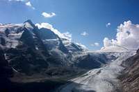
Grossglockner and Pasterze glacier
At the foot of the mountain on NE side flows the "Pasterze" (glacier), which is rapidly melting. But with 9 km length the Pasterze is still the longest glacier in the eastern alps. To this very impressive place leads the famous mountain road Grossglockner Hochalpenstrasse, one of the biggest tourist attractions of Austria when it is open (May to October).
On the shoulder at SE side of the mountain - called "Adlersruhe" (="eagle's rest") - is the Erzherzog-Johann hut (3454 m) situated. Just 350 m below the summit, built already in the year 1880, it is the highest hut in Austria (but, again, not in the eastern alps: higher are the Rifugio Marco e Rosa in the Bernina group and the Vioz hut in the Ortler group)
The Grossglockner is one of the "to do"-mountains (as Matterhorn and Mont Blanc) which also many non-alpinist want to climb once in a lifetime. So it can be noticed that often unexperienced and under-equipped people try to climb it. The normal route is more difficult than many other major mountains of the alps. From the Erzherzog-Johann-hut you have to cope with a 35-40 degree steep slope (pure ice in later summer) and with an exposed ridge rated UIAA II. If you are not a really experienced alpinist, taking the rope (with the ability to handle it) is a must. The rope should also be used for crossing the glaciers to the Erzherzog Johann hut from Stuedl hut or Franz-Josefs-Hoehe. Some have already fallen to death there because of crevasses!
The Grossglockner is also a playground for trained ice climbers. Some of the most difficult routes are at the north face, that can stand comparison to famous ascents at 4000 m-peaks in the western alps.
The Pallavicinirinne is the most classical of these routes. First climbed in 1877 when crampons were still unknown it has become famous because of the hard work of leading guide J. Tribusser who hit 2500 steps into the ice with his axe.
The mountain Grossglockner contains also the following summits:
- Klein-Glockner (3770m), separated by the Obere Glocknerscharte. The normal route crosses the Kleinglockner
- Glocknerhorn (3680m)
- Teufelshorn (3677m), both at the NW ridge of Grossglockner
- Glocknerwand (3721m), separated by the Untere Glocknerscharte. Rocks quality in the flanks is low, it is much more difficult than Grossglockner and more remote. And everybody wants to climb the highest point. So the Glocknerwand is not often climbed. Glocknerwand is a crown that consists of several towers: Pöschlturm (3721m), Hörtnagelturm (3719m), Hofmannspitze (3711m), Peterkaturm (3711m), Weitzenböckturm (3702m), Draschturm (3701m) and Gerinturm (3700m)
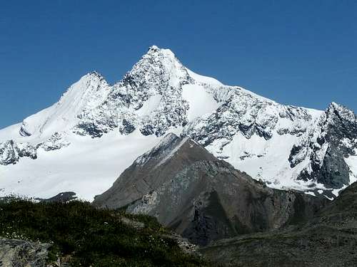 splendid Glockner from the south side
II. Glockner villages / getting there
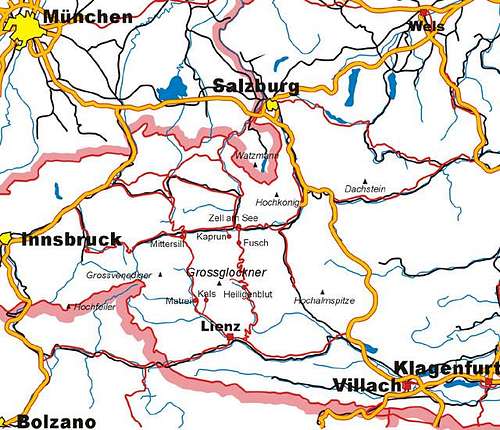
area map
If you want to climb or just visit and see the Grossglockner you have to decide between two villages: Kals and Heiligenblut - both of them carry the honorable addition "am Grossglockner"
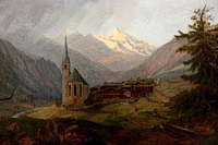
1. Heiligenblut am Grossglockner (1336 m)
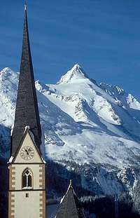
Heiligenblut church
... is at the south east side of the mountain and belongs to the province of Kaernten=Carinthia. Heiligenblut has the advantage that the mountain can be seen well from the village. The first expeditions to climb the Grossglockner more than 200 years ago started at Heiligenblut. Heiligenblut is starting (or ending) point of the mountain road "Grossglockner Hochalpenstrasse". Therefore many tourists are there in the summer season. From the Franz-Josefs-Hoehe, tourists have a spectacular view to the mountain and the Pasterze glacier. Heiligenblut is also a ski resort for winter season.
You get to Heiligenblut
- from the north over the Grossglockner Hochalpenstrasse (only in summertime!)
- from south via Lienz - Iselsberg pass
Grossglockner Hochalpenstrasse - Franz-Josefs-Hoehe
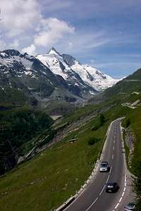
the most famous tourist road of the alps
The end point of the Grossglockner Hochalpenstrasse mountain road is the Franz-Josefs-Hoehe (2369 m):
The road crosses the main ridge of the alps from Bruck near Zell am See (province of Salzburg) to Heiligenblut (province of Carinthia). Highest point of the direct road is at the Hochtor-Tunnel (2505 m). A little bit south of it a dead end leads to the huge parking lot at the Franz-Josefs-Hoehe where you are as close as possible to the Grossglockner with mechanical help.
Fee for using the road for one day is € 26,00.
There is also a bus service between Zell am See and the Franz-Josef-Hoehe: bus timetable, that is of course only running in summer time when the road is open.
2. Kals am Grossglockner (1325 m)
road to Kals
Kals am Grossglockner is at the south west side of Grossglockner and part of the province of Tyrol (eastern part). The summit cannot be seen from the village, but you have the opportunity of using the cablecar to the "Glocknerblick" or the pay road "Kalser Glocknerstrasse". The tyrolean side of the mountain is by far not so spectacular, but the shortest and easiest ascent starts at the Luckernhaus at the end of the pay road. The citizens of Kals have decided in a plebiscit some years ago that a hydroelectric power station could not be built above the village. Only after this decision it was possible to found the Hohe Tauern National Park. Therefore around Kals you can find a lot of pure nature and it is a very nice village for a summer holiday.
You get to Kals via the Felbertauern-Road:
- from north via Kitzbühel - Mittersill - Matrei (Matrei in Osttirol, n o t Matrei am Brenner!). There is a fee of € 10,00 for crossing the Felbertauern tunnel
- from south via Lienz
From Huben a steep road to the northeast leads to the village.
Kalser Glocknerstrasse - Lucknerhaus
The Kalser Glocknerstrasse is a pay road (7 km long, fee for one day: € 9,00) that leads from Kals to the Lucknerhaus (1925 m). There you have also a wonderful view to the Grossglockner (although not so spectacular as from Franz-Josefs-Hoehe). The road is important for mountaineers because the shortest and easiest ascent to the Grossglockner starts here.
The road is open most of the winter and using is free in this time.
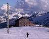
 classic view from Lucknerhaus
III. Huts
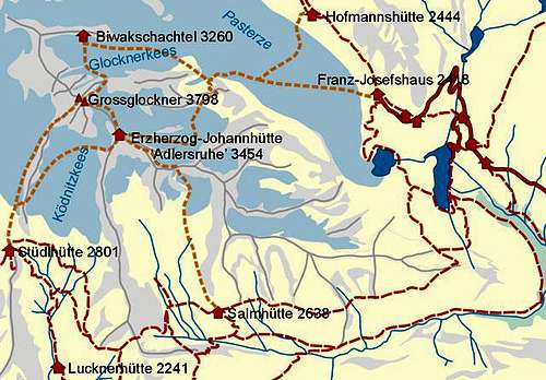 huts and routes around Grossglockner
1. Luckner-Haus (1918 m)

Luckner-Haus (1918 m) (homepage) - outside the map of this section -
Hotel at the end of the Kalser Glocknerstrasse. So this is not a necessary alpine hut. But is is a recommendable inn for staying some days in spring for backcountry skiing (perhaps including climbing the Grossglockner in a long day). Cheaper rooms with 6 beds available
2. Stuedl hut (2802 m)
Stuedl hut
Stuedl-Huette (2802 m)
104 beds; guided from Mid March to Mid May and from June to October
24 beds during the rest of the year - no special key necessary
Important hut for the normal route from Kals. It is not necessary to sleep at the Erzherzog Johann hut. The hut is also the basis for the ascent over the Stuedlgrat.
You get there
a) in a 2,5 h walk from the Lucknerhaus; after 1 h you pass the Luckner-Huette (2247 m) or
b) in 4 h from Taurer inn (1512 m) behind Kals (not so busy).
The hut was built in 1869 but there was a reconstruction in 1994-1996. The new hut looks a bit like the "barrel of Diogenes"
SummitPost page Stuedl hut
3. Erzherzog-Johann hut (3454 m)
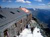
Erzherzog-Johann-Huette (3454 m)
highest hut in austria on a unique place at the shoulder of the Grossglockner. There is a panorama as from a summit. The hut was built in 1880.
120 beds, guided from June 23rd to end of September
Tel. +43(0)4876/8500 - hut when guided
Tel. +43(0)4876/8272 - outside guiding period
Email info@adlersruhe.at
outside the guided period there is an emergency room (4 places, no heating) accessible on the east side of the building.
Getting there is already more difficult than just hiking and requires gear for glacier climbs:
a) from the Stuedl hut (easiest and most popular): 3 h: marked path passing a big cairn to the Koednitz glacier. Then crossing the Koednitz glacier (rope recommended because of crevasses), then a steep but not difficult scramble (UIAA I, cables) to the hut
b) from the Salm hut: 3 h marked path (passing the ruine of the historic hut built for the first ascent!) to the Hohenwart glacier. Crossing the glacier (not much ice left) to the rocks of the Hohenwartscharte (3183 m). Cables make it easy. Crossing north east of the Hohenwartkopf and then along the ridge of the Salmkamp to the hut
c) from Franz-Josefs-Haus: 5 h
Descend to the Pasterze glacier and cross it. Ascent over the moraines to the beginning of the Hoffmannkees glacier (marked with cairns). Crossing the glacier (experiences and gear for it necessary) while ascending to the south, then at the north side of the Salmkamp in western direction to the hut. This used to be the most common ascent. But it has become more difficult in recent years because of shrinking glaciers and can be dangerous in later summer (from mid of July) because of stonefalls. The steep crossing of the Hoffmann glacier can only be recommended if there is still snow on the glacier.
4. Glockner-Haus (2132 m)

Glockner-Haus (2132 m)
historic inn, built in 1876 as an alpine hut, it is now situated at the Grossglockner-Hochalpenstraße between Heiligenblut and the Franz-Josefs-Hoehe. There are still privileges for members of the alpine clubs. So if you want to stay a night before going on the mountain I can recommend this inn.
5. Franz-Josefs-Haus (2363 m)

Franz-Josefs-Haus (2363 m)
Restaurant at the end of Grossglokcner Hochalpenstrasse mountain road. Used to be a hotel, but since a fire in 1997 no lodging is possible.
6. Hoffmann hut (2444 m)
the hut is situated half an hour walk behind the end of the road at Franz-Josefs-Hoehe. It is one of the oldest huts of the german/austrian alpine clubs, built in 1862. But it has lost its importance because of the near road end, the shrinking of Pasterze glacier and the comfortable and big Oberwalder hut above. The quality of the buiding became in the meantime too bad for a renovation. So the building has probably to be demolated. It is a matter of cost and is not decided yet if a reconstruction of a new builing is possible.
So this is a rather sad story...
7. Oberwalder hut (2973 m)
Oberwalderhütte (2973 m)
The Oberwalder hut is not a base for climbing Grossglockner directly, because it lies on the opposite side of the Pasterze glacier, on the "pulpit" of the Grosser Burgstall. But it is the biggest hut of the Glockner Group and an important base of the austrian alpine club for alpine education.
109 places, guided from mid May to end September
2,30 h from Franz-Josefs-Hoehe along the new "Gamsgrubenweg"-trail, later over the Wasserfallwinkel glacier to the Grosser Burgstall.
The Gamsgruben trail may not be possible in winter/spring with Ski because it cuts steep slopes. Then it is necessary to descend to the Pasterze glacier and climb Grosser Burgstall from the backside, just before the big serac zone of the glacier (4 h, I guess)
From the hut you can do the famous ski trip around Grossglockner and many mountains of the Glockner group can be climbed, e.g. Glocknerwand, Romariswandkopf, Johannisberg, Hohe Riffl, Fuscherkarkopf
8. Salm hut (2634 m)
Salm-Huette (2634 m) is on the south side of the muntain. The historic first ascent of the Grossglockner was done from this side of the mountain with building of the first Salm hut. 'Still it is recommendable to climb Grossglokcner from there because there is no crevasse danger to reach Adlersruhe (Erzherzog Johann hut) from this side.
you get there
a) 4,5 h direct from Heiligenblut following the Leiter valley
b) 3,5 h from the Franz-Josephs-Hoehe via the Stockerscharte, mountain path with some exposed sections
c) 1 h from the Glorer hut (that means 3,5 h from the Lucknerhaus)
d) 3 h from the Stuedl hut via Pfortscharte (lose rocks)
9. Glorer hut (2642 m)
Glorer-Huette (2642 m)
- outside the map of this section -
the Glorer hut is at the pass when you hike from Heiligenblut to Kals or vice versa.
a) 2 h from the Lucknerhaus
b) 4,5 h from Heiligenblut
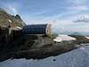
9. Glockner bivouac (3205 m)
Glockner-Biwakschachtel (3260 m)
small hut with 8 places at the northern border of the Innere Glocknerkees, not guided. This is the necessary basis for doing the difficult climbs on the north side of the Grossglokcner, esp. the Pallavicinirinne. Always crowded when conditions are good on fine weekends from May to July.
3 h from the Franz-Josefs-Hoehe via the Pasterze glacier
 |
 |
 |
 |
 |
IV. Routes overview
(thanks for this section to Ari)
Climbing Grossglockner is a goal for thousands of climbers each year. Some of them are not well enough informed or not experienced enough and get into dificult and dangerous situations. In order to provide better information the austrian alpine club has invented a brochure. You can download it
- Here in English
- Here in German Language
- Here in Italian Language
- Here in Slowenian Language
- Here in Czech Language
1. normal routes
the easiest and most common route is from Erzherzog-Johann-hut:
PD, glacier 35°, UIAA II
a good alternative with starting point Stuedlhuette is:
south west ridge "Stuedlgrat", ridge climb, III -IV
First ascent of Stuedlgrat by J. Kerer & P. Groder 10.9.1864.
 |
 |
 |
 |
 |
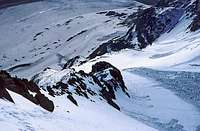
2. north routes
 impressive north side of Grossglockner
at the famous and impressive north face of Grossglockner are several ice climbs with various difficulties:
Berglerrinne, culoir ice climb, 45-50°, III
First ascent of Berglerrinne to Oberer Nordwestgrat by E. Rainier 9.9.1929 (Ridge to the top climbed
already 29.8.1879 by G. Groeger & Chr. Ranggetiner).
First ski descent of Berglerrinne by St. Eder 24.5.1980.
Pallavicinirinne, couloir ice climb, 55-60°, III
First ascent by A.Pallavicini, J. Tribusser, G. Baeuerle & J. Kramser 18.8.1876.
First solo by A. Horeschowsky 6.7.1924.
First female ascent by Maria Zeh & Th. Zeh 28.6.1926.
First winter ascent by R. Goetz 5.2.1953.
First ski descent by G.Winter & H.Zacharias 7.8.1961.
First female ski descent by Ivana Filová, 4.5.2003
north face. Welzenbach Route, mixed, IV+, 55°
First ascent by W.Welzenbach & K.Wein 19.9.1926.
"On that occasion [Willo Welzenbach] and Karl Wien, arriving in Austria on a Saturday morning after a tiresome overnight rail journey from Munich, cycled some 20 kilometers up the Fusch Valley and crossed a pass involving 1600 metres of ascent to reach the hut serving as a base for their route. With a 2:30 a.m. start on Sunday, they completed their intricate 1400 metres of ascent [of the Grossglockner North Face], in which the face of 600 metres is now recognized as one of the hardest mixed climbs in the Eastern Alps, and returned to base by dusk. Assisted by a full moon, they re-crossed the pass to the Fusch Valley that evening and cycled down to the railway station to catch the night train back to Munich."
(Eric Roberts, Welzenbach' s Climbs)
First winter ascent by P.Nagy, R.Thaler 2.-4.3.1964.
Mayerlrampe (Glocknerhorn Nordwandrampe), ice climb, 60-70°
First ascent by S.Mayerl, H.Lindner & H.Messner 19.10.1967.
First winter ascent by etodnig & G.Rpsenfelder 3.-4.1.1970.
First descent of by W.Sucher, K.Hoi; A.Fluer, H.Mitterer, F.Muehlegger & G.Santer, 2.9.1979.
ice nose ("Theo-Riml-Gedenkanstieg"), ice climb, 90°
First ascent by K. Hoi, L. Baumgartner, G. Haefele, W. Haiden, W. Laserer & M. Rust, 29.8.1984.
direct north face, 90°/mixed
First ascent by K.Hoi, L.Baumgartner, St.Lackner, A.Prugger & H.Christoph, 30.8.1985.
 |
 |
 |
 |
 |
3. other routes
south face, IV, 40-45°
First ascent of Suedwand by V. Pillwax, P. Unterberger & S. Huter 29.6.1891.
Starting point Franz-Josefs-Hoehe:
Meletzkigrat (Glocknerkarkamp), PD, II, 35°
First ascent of Meletzkigrat by A. Gulden, H. Gulden, H. Mechwart, J. Bernsteiner, A. Lackner & J. Rubitsch 27.7.1892. The route was forgotten for long, until E. Meletzki and G. Hecht used the route
again 2.9.1925.
 |
 |
 |
V. skiing
Grossglockner is also a great mountain for skiers. Normal (not extreme) ski dwonhills can be done from below Kleinglockner, from where you have some 1500m of descent. The climb of the summit itself is not much more difficult as in summer, if snow conditions are good and it is done very often in late winter and spring. There is a danger of big corniches at the Kleinglockner.
The usual ski tour towards NE goes down the Hofmannskees to Pasterze glacier - the same route as summer ascent.
More popular is ascent from and and downhill to SW from Lucknerhaus and Stuedlhut. It is possible to ski from below the rocks of Adlersruhe and over Koednitzkees and, if conditions are good, also from below Kleinglockner and directly down to Koednitzkees.
Also Popular is the so-called "Glocknerumfahrung" (Drive arround Grossglockner): Franz-Josefs-Hoehe - Oberwalder hut - upper Pasterze glacier - Romariswandsattel pass - Romariswandkopf - downhill to Stuedl hut - Erzherzog-Johann hut - Downhill to lower Pasterze - Franz-Josefs-Hoehe.
The trip requires an experienced ski mountaineers, rock climbing up to UIAA II is necessary. Some variations of the route are possible and of course the climbing of Grossglockner itself in addition.
Athletes do this in one day, normal climbers sleep a night at Stuedl hut
And finally - in good conditions the best skiers also ski down the Pallavicini couloir. SP member filova probably was the first woman to do this!!
 |
 |
 |
 |
 |
VI. mountain guides
If you want to climb the Grossglockner but you are not so experienced, going with a mountain guide is a possibility. The Mountain guides in this area, especially in Kals, have a long tradition since 1869.
More infos on the website of the Kalser Bergfuehrer (in german)
Price for a solo tour with a guide is € 260,00, much cheaper with more persons
VII. historic ascents
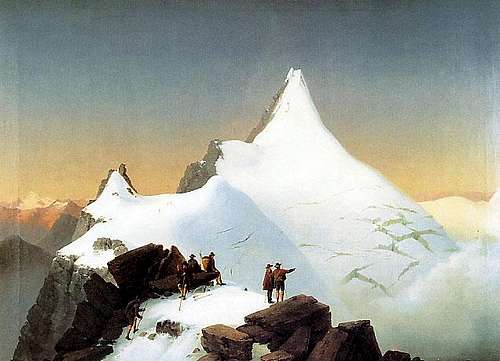
painting by Markus Penhart
Wagner painting of 1832
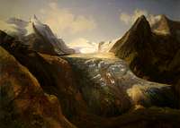
Thomas Ender painting of 1834
The history of the climbs started with Belsazar Haquet, a scientific professor of Ljubljana. He travelled in the area in 1779-1781 and wrote a book in 1783 where he described the mountain and stated that it had not been climbed yet.
Inspired by the book the local bishop, cardinal Franz Xaxer Salm-Reifferscheid, started efforts for an expedition and engaged two carpenters of Heiligenblut, Martin and Sepp Klotz, to do the first explorations for an ascent through the Leitertal valley, which is the side of Grossglockner with the least ice (people feared glaciers in these times). The two brothers did more than they were ordered to do - and probably reached the summit of the Kleinglockner on July 23, 1799.
One month later the expedition of the cardinal started: a hut (the first Salm hut) was built and the path in the Leitertal valley was prepared so that the cardinal could use a horse to reach the hut. 30 people were part of the expedition. They suffered with bad weather. A first effort failed, but on August 25, 1799 the brothers Klotz and at least 4 other people reached - again the Kleinglockner. There they installed a cross (one of the main goals of the church expedition). The reports did not tell clearly that they had not touched the highest point but the cardinal (who had reached the Adlersruhe) was informed. He was not satisfied and invented another, even bigger expedition the next year.
On July 27, 1800, 62 (!) people started again into the Leitertal valley.
On July 28 the climb started. 4 carpenters (the brothers Klotz and two others who are not known) did a track in the snow and installed fixed ropes at some steeper sections up to the end of the Glocknerleitl. But only these four and P. Horasch, the local preast of the village Doellach, were able to cross the Obere Glocknerscharte and climb Grossglockner summit.
The next day the carpenters and some others (among them Valentin Stanic, who climbed some weeks later Watzmann for the first time) did the climb again and installed the summit cross, now on the really summit.
First solo ascent by Corbinian Steinberger on August 17, 1851 (shortly later he climbed Koenigspitze for the first time).
First winter ascent by W.A. Baillie-Grohmann, P. Groder, A. Kerer & K. Gorgasser on January 2, 1875
VIII. Camping / Accomodation
Camping is forbidden in the national park but alpine bivouacs are allowed. Climbers normally use one of the huts.
There is the Glockner Camping near Heiligenblut.
Nearest camping sit on the tyrolean side is at Matrei, about 20 km away from Kals:
Camping Edengarten
Familie Steiner
A-9971 Matrei, Edenweg
Tel. ++43/4875/5111, Fax. ++43/4875/5111
In the villages you have plenty of hotels, bed&breakfast.
IX. mountain conditions
weather: Alpenvereinswetterbericht weather report for the whole alps, in german, done by the office in Innsbruck/Austria
north routes: see these threads in german on www.bergsteigen.at
or here on gipfelbuch.ch
Other sections of these websites have info about conditons of normal climbs or ski tours.
here on "www.gletscherarchiv.de" you can see how dramatically the Pasterze glacier has melted away during the last century. And this seems still not to be the end...
a new satellite picture of Pasterze glacier can be found here
Webcams
Lucknerhaus;above Kals: impressive view of Grossglockner south side with the normal route from Kals - this is over all my favorite webcam. If today is not fine weather, you can look at the photos of this section.
Glocknerblick cablecar above Kals
Grossglockner Road above Heiligenblut
view from Franz-Josefs-Hoehe
 |
 |
X. When To Climb
The normal routes are best in July, August, September. At this time the huts are guided. If conditions are good you will never be alone on this mountain. The "traffic jams" at the Obere Glocknerscharte between Kleinglockner and Grossglockner summit on the normal route are legendary. So please try to avoid the weekends when the mountain is most overcrowded.
The famous and difficult ice climbs at the north face have become too dangerous in recent years in this summertime due too melting ice and very increased danger of stonefall. Some couloirs have not snow at their bottom in this time.
So the best time for these ascents has become May and especially June in spite of the fact that thunderstorms are likely. Another possible time is late autumn - when a high pressure period follows the first heavy snowfall. At this time - even if conditions fit - there is much less "traffic" in the routes.
Although the summit cannot be reached with ski, the normal route to Grossglockner is often done from March to May. You have to leave the ski above the Adlersruhe. The Stuedl hut is guided at that time
XI. Maps and books
best map is Alpenvereinskarte 1:25000 Nr. 40 Grossglocknergruppe, to order at DAV Shop
Also available at Greul mountain books
Guidebook in german: Willi End: Glockner- und Granatspitzgruppe, 11th edition 2010, Bergverlag Rudolf Rother, Müchen; ISBN: 3-7633-1266-8
Seibert Dieter: Eastern Alps - the Classic Routes on the Highest Peaks; Diadem Books, 1992. ISBN: 0-906371-54-6; edition 1995 on amazon.com
Grossglockner by Wolfgang Pusch and Leo Baumgartner, monography of the mountain, Bergverlag Rother Muenchen, 2001, ISBN 3763375090, EUR 29,90, in german (not found on amazon.com - there seems to be no english edition); with great photos, history and a description of every route including the extreme ones.
 |
XII. National Park
The mountain is located in Hohe Tauern National Park but in effect that does not limit climing activity. There is only a small area near to the Franz-Josef-Hoehe that is not allowed to enter because of very unusual plants ("Sonderschutzgebiet Gamsgrube"). but you do not cross this section on the routes to the Grossglockner.
If you can touch marmots near the Franz-Josefs-Hoehe: this has nothing to do with protection of the national park. They have become tame because the tourists feed them all the time.
XIII. Summit Views
The views from the summit are astonishing. Proofed landmarks that can be seen in theorie are Piz Bernina and the adriatic sea.
 |
 |
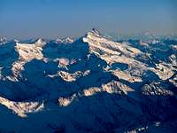
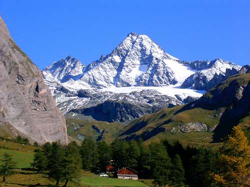
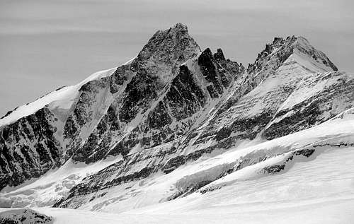
XV. distant views
Because the Grossglockner is by far the highest peak of it's area, it can be seen very well from other mountains - if the weather conditions fit. The pictures of this section shall show this.
 |
 |
 |
 |
 |
XVI. about the name
(thanks to cjaniesch)
The first recorded mention (as “Glocknerer” on a map of the area) of the name “Großglockner” dates back to 1561 but the actual origin of the name remains to be determined. There seem to be three possibilities: In the first place it might be derived from the shape of the mountain, as it resembles a church bell (German = Kirchenglocke) from the Ködnitz Valley and a “Glocke” (a kind of cloak from the 15th century) from Heiligenblut. The name could also come from a word of the local dialect, namely “gloggen” , meaning “donnern/ poltern” (to thunder/to rumble). This might hint at the frequent ice avalanches and rock fall in the area around Großglockner. The last alternative for the origin of the name of Austria´s highest peak is a word used in the Mölltal – “Glogger” (Leithammel) which translates to bell- weather.
So, sometimes it´s not so simple as one might think...
External Links
- Great Photo Gallery of Gross-Glockner Pictures
High Resolution Images and Photos for the Desktop. German. - Grossglockner at Berge der Welt
A bit of history in German and some photos. - Glocknergruppe at Österreich Lexicon
- Glocknerhaus
Alpine Restaurant and Motel near Franz-Josefs-Höhe. Site has weather cam. - 200 Jahre Grossglockner
Article by Peter Grimm at DAV Panorama 4/2000. Excellent article in German. - Grossglockner Hochalpenstrasse
official website of the famous mountain road - Grossglockner via Glocknerleitl
filova - Nov 28, 2003 4:36 am - Hasn't voted
Untitled CommentSki descent description in German at www.bergsteigen.at/berichte/pallaski/pallaski1.html
filova - Dec 3, 2003 9:06 am - Hasn't voted
Untitled CommentWe succeded on May 4, 2003 in ski-descending of Pallavicinirinne from Grossglockner (N-Face). We were 5 skiers from Slovakia (4 man and 1 woman): Iva Filova (female skier), Martin Jurik, Miro Zavodsky, Bohus Stofan and me (Rasto Krizan). It is not steeper than 50 degrees. Since Friday (May 2) we were waiting for better weather and suitable snow conditions at the Glockner Biwak Schachtel. "Fortunately" on Friday and on Saturday it was snowing and there was a strong wind. As a result snow was glued on the icy surface of the couloir making it possible to overcome unfriendly icy parts. On Sunday at 7H00 in the morning, we left the Schachtel. After 2 hours we reached the top part of the snowy section of the couloir and started descending. At the beginning the snow was dangerously wet and unstable because of long sun exposure. Lower we went the better surfface we were encountering. At 11H00 we were all back in the Biwak Schachtel. That was not the first time we were there trying to make this ski descent. Me and Bohus Stofan, 5 years ago, made first attempt, but the surface was extremely icy, impossible to ski down. Bohus recently made second fully winter attempt (in December) but found the same unfriendly conditions in the couloir.
dmiki - Oct 10, 2007 10:50 am - Hasn't voted
broken linkThe http://basislager.ch/az/nord.php link is broken
Mathias Zehring - Oct 10, 2007 1:29 pm - Hasn't voted
Re: broken linkbasislager does not exist any more - I changed the links to www.gipfelbuch.ch. Thank you for your note!
dmiki - Oct 11, 2007 7:53 am - Hasn't voted
A possible link for weather conditionshttp://www.wetter.at/wetter/sport-freizeit/berg-wetter/oesterreich/kaernten/grossglockner
Diego Sahagún - Dec 31, 2007 6:11 am - Hasn't voted
Sorry...Mathias, Erzherzog-Johann hut (3454 m) link doesn't work. http://www.tiscover.at/guide/5,de,SCH1/objectId,IND472486at,curr,EUR,parentId,ACC105067at,season,at1,selBlk,ADDPGBLK,selElem,BKE9VYat/intern.html