Overview
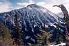
It is definitely ovoid from most viewing directions. And it is certainly composed of yellowish rock. So, with a wild eye, you could suppose the mountain to be the yolk of a fried egg. Futhermore, from the northwest--say from
Reynolds Peak--the mountain rises above its surroundings with the girth and prominence of a stratovolcano. Yet it is definitely not a volcano. It is non other than Oval Peak--the highest summit in the Lake Chelan-Sawtooth Wilderness* in the area to the east of Lake Chelan. Yes, Oval is a good name for this peak.
* The actual high point of the Wilderness is Gardner Mountain (8,897 ft) at the northern edge, somewhat north of the northern tip of the lake.
Oval Peak is not even really on the crest of Sawtooth Ridge, but instead lies a couple of miles northeast of the crest on an outlier ridge. The mountain is characterized by talus, talus, and more talus. It is King Talusus, ruler of Chossdom. Even so, it is quite high and as such affords a listing on the Washington Top 100 (at approximately 28th highest in the state). There are really no other distinctive features about the peak. Aesthetically, it is nothing compared to its neighbor two miles to the southwest: 8,690-ft
Star Peak. As with a few of the other peaks in the region, it does contain a small rock glacier, but it's not much to see.
Getting There
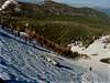
To get to Oval Peak, drive to the Methow River valley and then up the Twisp River Road. Subsequently, you can approach the mountain either via West Fork Buttermilk Creek Trail No. 411 (3 or 4 miles to base of mountain), Oval Creek Trail No. 410A (4 miles to base of mountain), Scaffold Camp Creek northeast of the peak (3 miles of cross-country), or the long northeast ridge that divides Oval Creek and Scaffold Camp Creek. The most intimate of these approaches would be the last two described. Once you get sufficiently high up in altitude, the brush abates significantly as this area of the Cascades receives much less rainfall than points west. The first two approaches are on easy well-maintained trails. If combining a climb of Oval with climbs of Star Peak and Courtney Peak (the other two Top 100 summits in the Oval area), then the West Fork Buttermilk Trail is the way to go. The Greentrails map for the area apparently shows an upper trail that more or less parallels the W. Fork Buttermilk Trail and then joins it closely east of Fish Creek Pass. This very obscure and unmaintainted trail starts on or near Scaffold Ridge about 4 miles ENE of Oval Peak. After a few miles, the trail can really only be tracked by following blazes.
The mountain could be climbed from pretty much any direction, though the north side does have cliff bands to contend with. The South Face is chossy with big blocks but not cliffy. The best ascent routes are either via the broad East Ridge or the South Ridge. Both of these routes are day trips from the car.
Red Tape
Permits are not really required in the region though one of those annoying Trail Park Passes may be requested.
When To Climb
The mountain could be climbed year-round. In the winter and early spring it would be an excellent ski tour. In summer or early fall it's an all talus hike. Not many objective dangers other than loose blocks. 90% class 2.
Camping
There are some campsites along the trail, but the terrain is pretty open so you could camp almost anywhere. Care should be taken not to trample native vegetation. The basin south of the peak would be a nice place to camp (there is a small, boggy pond there). Heck, one could even camp on the summit. It's broad and flat but water would be scarce in late-season.
Mountain Conditions
It can be hot or cold or in between in the Lake Chelan-Sawtooth Ridge Wilderness. Ordinarily, you won't get much frontal rainfall as the wilderness is far east of the Cascade Crest. What does blow over is usually highly dissipated or scattered once it gets to the area. However, the area is prone to thunderstorms in the summer. I have been snowed on in the area in early September.
Localized Forecast


ericnoel - Aug 11, 2008 2:43 pm - Voted 10/10
First ParagraphNice page Paul. For what it is worth, I believe that Gardner is actually the HP of the Lake Chelan Wilderness as it is right on the wilderness border and of course it is a bit higher than Oval.
Klenke - Aug 12, 2008 1:48 pm - Hasn't voted
Re: First ParagraphThanks. My current sentence is not incorrect in so much as Oval is the highest point "east" of Lake Chelan (the Gardners aren't really "east" of the lake). But I will clarify the sentence and add in your Gardners info (I also own [took over] the Lake Chelan-Sawtooth Wilderness area page a couple of years ago...but I haven't really done anything with it). I see you climbed Oval. What? You no like talus? This weekend I spied on Speelyai Ridge. Oh yai!
ericnoel - Aug 13, 2008 12:29 pm - Voted 10/10
Re: First ParagraphI see what you are seeing about it being the HP to the E of Lake Chelan since Gardner is not really along the Lake Chelan crest. Yeah, we did Star then Courtney then Oval. Taken by itself Oval might not be too bad but the three combined exceeded my recommended weekend intake of Vitamin Talus.