
|
|
Mountain/Rock |
|---|---|
|
|
46.60980°N / 12.88630°E |
|
|
Hiking, Mountaineering, Scrambling, Via Ferrata, Skiing |
|
|
Spring, Summer, Fall, Winter |
|
|
9120 ft / 2780 m |
|
|
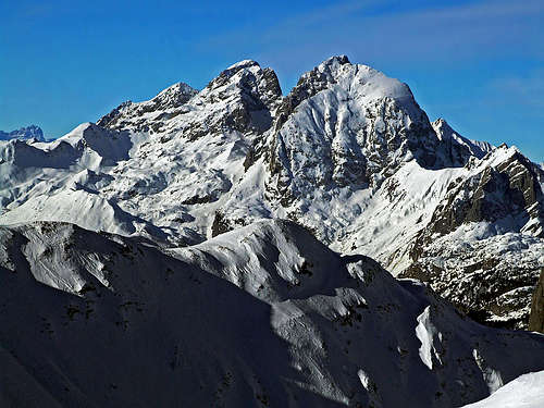
Overview
 WWI view
 Sunset (ClaudioNC)
 From Creta Monumenz
Monte Coglians/Hohe Warte is the highest mountain of the Carnic Alps , and without doubt one of the most beautiful summits of this part of the Alps. It is the main summit of an impressive ancient massif composed by interesting other summits like Creta della Chianevate/Kellerspitzen. The 360° view from the summit is really fantastic, if the sky is clear you can admire hundreds of mountains of the Carnic Alps, the Dolomiti, the Hohe Tauern group, the Lienz Dolomites, the Julian Alps, and also the beautiful hills and plains of the Friuli-Venezia-Giulia.
The massif of Monte Coglians/Creta della Chianevate is definitely one of the most impressive of the Carnic Alps main ridge, with very high walls and sharp crests. This mountains are mainly composed by limestones originated in the Devonian age ( 410-360 million years ago ).
The name of this mountain means just "mountain of Collina" ( the small village on its foothills ), from the latin word collis/coliàns.
During the First World War Monte Coglians, like all the mountains of the ridge, was a stronghold of the Italian Army, and you can still find rests of that period. On the top there was a small fort built by the Dronero brigade of the Alpini ( italian mountain troops ).
First Ascent: 30 september 1865, Paul Grohmann, through the actual Italian Normal Route.
Getting There
 From Monte Dimon (Vid Pogachnik)
FROM ITALY
Passo di Monte Croce Carnico
From the Udine-Tarvisio motorway exit Tolmezzo and then Paluzza, Passo di Monte Croce Carnico.
From Venezia to Belluno-Lozzo di cadore-Passo della Mauria-Villa Santina-Tolmezzo-Paluzza-Passo di Monte Croce Carnico
From the Brennero motorway exit Bressanone/Brixen and then S.Candido-Auronzo di cadore-Passo della Mauria-Villa santina-Tolmezzo-Paluzza-Passo di Monte Croce Carnico
Rifugio Tolazzi
From the Udine-Tarvisio motorway exit Tolmezzo and then Villa santina-Forni Avoltri-Collina-Rifugio Tolazzi
From Venezia to Belluno-Sappada-Forni Avoltri-Collina-Rifugio Tolazzi
From the Brennero motorway exit Bressanone/Brixen and then S.Candido-Sappada-Forni Avoltri-Collina-Rifugio Tolazzi
FROM AUSTRIA
From the Plocken Haus, near Passo di Monte Croce Carnico/Plocken Pass ( E66 exit Oberdrauburg, then take the road to Mauthen and to the border ), you can reach the Valentin Alm and the starting point of the routes on the north face of the mountain.
Routes Overview
There are three main routes to climb this mountain:The very popular Normal Route that goes up on the southern big ravine, which is the only "weak" side of Monte Coglians. For expert hikers, short passages of the UIAA I degree in the last part.
The Via Ferrata "Weg der 26er", a very modern and challenging ferrata on the vertical north face. Only for via ferrata experts.
The Old route on the north face, a partly secured alpinistic path, with short passages of the UIAA II. The last part on the western crest is the same for both routes.
 From South
Climbing Routes
 From Cima di Mezzo
There are several climbing routes on this mountain but the quality of the rock is not very good. Here's a list of the most known:
- Southwest Face
Rated: IV
First Climbed: 1941 (Aurelio, Terribile, Pinamonti)
Length: 600m
- West Face
Rated: II
First Climbed: 1933 (Caneva, Candido)
Length: 600m
- South-West Face of the North Ridge
Rated: III
First Climbed: 1921 (Haberl, Nießner, Sickenberg)
Length: 600m
- North-West Ridge (from Seewarte)
Rated: III
First Climbed: 1921 (Hinterberger, Mayer, Schneck)
- Western (First) North Face Chimney
Rated: IV
First Climbed: 1930 (Peterka, Proksch)
Length: 250m
- Central (Second) North Face Chimney
First Climbed: ? (Samassa)
Length: 250m
- Third North Face Chimney
Rated: III+
First Climbed: 1976 (Unterluggauer et al.)
Length: 250m
- Eastern (Fourth) North Face Chimney
Rated: III+
First Climbed: 1897 (Samassa, Urbanis)
Length: 200m
- Felfernigg - Cermenjak Route
Rated: III+
- North Face / Koban - Prunner Ferrata
Rated: II
Length: 500m - North Face / Kofler Route
Rated: III
First Climbed: 1895 (Kofler)
Length: 650m
- North Face /Damberger Route
Rated: II
First Climbed: 1922 (Damberger, Steiger)
Length: 200m
- Direct North-EasternPillar
Rated: IV+
First Climbed: 1933 (Rittsteuer, Pichler)
Length: 250m
- North-East Pillar /Peterka Route
Rated: III+
First Climbed: 1932 (Peterka, Zimmermann)
Length: 250m
- North-East Pillar / Castiglioni Route
Rated: IV
First Climbed: 1937 (Castiglioni, Bozzoli, Barzaghi)
Length: 250m
- North-East Face
Rated: IV+
First Climbed: 1933 (Peterka, Souscheck, Fraisl, Köckenbauer,Fischer)
Length: 700m
- North-East Face of the Eastern Summit
Rated: III+
First Climbed: 1927 (Kaser, Gebauer)
Length: 700m
Accomodation
 Rifugio Marinelli
Rifugio Tolazzi
Rifugio Marinelli
Rifugio Lambertenghi Romanin
Eduard Pichl Hutte
Gasthof Valentin Alm
When to climb?
From june to october. There can be snow on the north face until mid summer. Winter ascents are possible for experts with full winter gear. The normal route can be very crowded on the weekends of july and august.Meteo Friuli
Books and Maps
Maps- Lienzer Dolomiten / Lesachtal
1:50000
Kompass Map WK47
Kompass Verlag
ISBN: 3-85491-053-3
- Gailtaler Alpen / Karnische Alpen / Oberdrautal
1:50000
Kompass Map WK60
Kompass Verlag
ISBN: 3-85491-067-3
- Tabacco Maps, all 1:25000
001 - SAPPADA-S.STEFANO-FORNI AVOLTRI
009 - ALPI CARNICHE / CARNIA CENTRALE
Books
German Books
- Hiking and Trekking
- Osttirol Süd
W. Mair
Rother Verlag
ISBN: 3-7633-4132-3
Good descriptions with maps covering: Defregger Berge, Villgrater Berge,
Carnic Alps, Lienz Dolomites
- Kärnten
G. Lehofer
Rother Verlag
ISBN: 3-7633-4187-0
Good descriptions with maps covering: Carnic Alps, Gailtal Alps,
Karawanke, Julian Alps (parts)
- Gailtal – Lesachtal – Karnischer Höhenweg
Kompass Wanderbuch 982
Kompass Verlag
ISBN: 3-85491-500-4
Good Descriptions with maps and elevation profiles covering: Carnic
Alps, Southern Lienz Dolomites, Gailtal Alps
- Osttirol Süd
- Climbing
- Karnischer Hauptkamm
Alpenvereinsführer
P. Holl
Rother Verlag
ISBN: 3-7633-1254-4
Excellent overall Climbing Guide through the Carnic Alps Main Ridge.
- Karnischer Hauptkamm
- ALPI CARNICHE E DOLOMITI FRIULANE
ISBN: 88-86928-37-8
Euro 16,53
to buy it
- ALPI CARNICHE, vol. I - II
A. De Rovere, M. Di Gallo;
Guida dei monti d'Italia CAI-TCI; 1988
W.Shaumann - E.Eybl - Passo di Monte Croce Carnico Storia, Escursioni e Paesaggio - Ghedina e Tassotti Editori
R.Mazzilis-L.Dalla Marta - Dai sentieri attrezzati alle vie ferrate - Editrice Co.El
A. e F. Scrimali - Alpi Carniche Escursioni e testimonianze sui monti della Grande Guerra - Edizioni Panorama
E.Tomasi - Traversata Carnica & Karnischer Hohenweg - Edizioni Svevo