
|
|
Mountain/Rock |
|---|---|
|
|
38.62560°N / 106.2505°W |
|
|
14162 ft / 4317 m |
|
|
Overview
At 14,162 feet elevation, Tabeguache Peak is the 26th highest peak in Colorado. It is one of the lesser known of the Colorado 14ers (peaks above 14,000 feet elevation). Situated at the southern end of the Sawatch Range, it lies approximately 15 miles Northwest of Salida, but is much shyer than its easterly neighbor. Because it sits in the shadow of its higher and more prominent neighbor, Mount Shavano, it attracts little attention from the casual observer. Climbers of the 14ers know it better.Tabeguache Peak is often climbed in conjunction with Mount Shavano. Previously, Tabeguache seemed a more significant mountain because the bulk of this route to both peaks took place on its slopes. The standard route to Shavano was over the top of Tabeguache. These roles are now often reversed. Concerns about erosion on the Jennings Creek route up Tabeguache caused the Forest Service to close the old standard route in September, 2002 (see Red Tape section below). The standard routes for Tabeguache Peak are either over the top of Shavano or the West Ridge.
Tabeguache Peak offers better views than its higher neighbor. In particular, the view towards the north is one of the best vantages from which one can gauge the scale of the Sawatch Range. The view seems to go on forever. The mountain offers little in the way of technical difficulty, but does possess some fine snow routes on its north face.
The name is most often pronounced "tab-a-wash" (sometimes "tab-a-watch").
 Tabeguache as seen from the summit of Shavano.
Getting There
Jennings Creek Trailhead:From the intersection of US 285/US 50 in Poncha Springs, drive west on US 50 for ~6 miles and turn right (north) on County Road 240. After ~3 miles the pavement ends. The Angel of Shavano Campground is 0.6 miles farther.
The road gets rougher after the campground and may require 4wd (though we made it fine in our Subaru). The trailhead is 3.8 miles beyond the Angel of Shavano Campground. Note that the forest service closes this road periodically due to logging operations and for other reasons.
Before heading out, make sure to check the Alters and Notices from the National Forest for road closures.
Blank Gulch Trailhead:
Turn west on Chaffee County Road 140 from US 285 about one mile north of the US 285/US 50 intersection in Poncha Springs. After 1.75 miles, turn north at the intersection with Chaffee County Road 250. (Chaffee County Road 250 can also be reached by driving 1.7 mile west on US 50 from Poncha Springs.) After an additional 3.9 miles from this intersection take the left fork in the road to Chaffee County Road 252. Follow this road, staying straight and on the most traveled path, for 3.2 more miles to the trailhead.
Browns Creek Trailhead:
From Buena Vista, drive south on US 285 ~10 miles. Turn west onto County Road 270. Drive 1.5 miles west on CR 270 and continue straight on CR 272 another 2 miles to an intersection. Stay left on County Road 272 and follow the road another 1.5 miles to the trailhead.
Routes Overview
Below are summaries of the main routes up Tabeguache Peak. See all the route pages for more details.If you have access to a car shuttle, the easiest way to climb both Shavano and Tabeguache together is to go up the Blanks Gulch Route and down the West Ridge Route or vice versa. That will avoid having to reclimb either peak on the return trip.
Shavano-Tabeguache Ridge via Blanks Gulch
This route climbs Tabguache Peak over the summit of Mount Shavano. The route is not difficult, but stays above timberline for a very long distance if you backtrack back over the summit of Mount Shavano.
This route is 11.5 miles round trip with 5600 feet elevation gain. Click Here for another route variation combining Peak 13712 and Jones Peak with Tabeguache and Shavano.
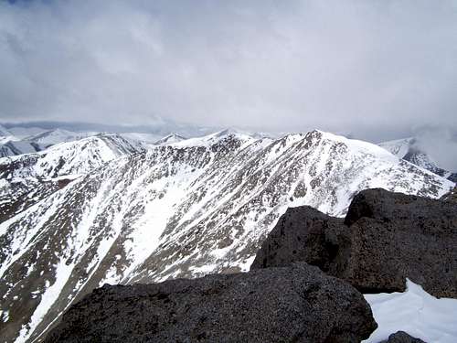
 Tabeguache Peak from Mount Shavano.
South/Southwest Ridge via Jennings Creek
CLOSED! Do not use this route See "Red Tape" below.
West Ridge via Jennings Creek
When the road is open (see "Getting There" above), this is currently the standard route to Tabeguache Peak. It is a bit longer than the old standard route (which is now closed) up Tabeguache and starts at the same trailhead.
The round trip distance to the summit and back is 7.2 miles with 3900 feet elevation gain.
 High on the West Ridge of Tabeguache Peak.
North Face via Browns Creek
This is a lesser known route on the north side of the mountain. The base of the north face can be reached from the Browns Creek Trail or from Mount Antero to the north.
There are a few routes and couloirs (the couloirs are snow climbs) on the north face which can be used to climb the peak.
 North Face of Tabeguache Peak.
McCoy Gulch
One of the classic 14er route finding errors is to drop south from Tabeguache too early when descending the Jennings Creek route. This puts one into McCoy Gulch instead of the Jennings drainage and has lead to numerous calls for search and rescue teams to locate stranded hikers. What appears to be another reasonable route off the mountain turns out to be an invitation to a narrow, difficult canyon not visible from above (which is good if you are a canyoneer with a rope, but bad if you are hiking without a rope).Photo Gallery of the Canyon
Red Tape
No permit is required to climb Tabeguache Peak.The old Jennings Creek Route up the South/Southwest Ridge is closed. DO NOT USE THIS ROUTE.
This route has been closed by the Forest Service as of September, 2002. The route had begun to exhibit severe erosion due to highly unstable soils. Multiple deep erosion gullies now scar the landscape between 11,200 feet and 12,600 feet elevation.
When To Climb
Since these mountains are much drier than those to the west or north, the snow doesn’t stick around as late as on some of the other mountains in Colorado. Relatively snow free conditions can usually be found by early or mid-June. From there through September would be considered to be the normal season to climb, though watch out for early season snowstorms.As always, summer is thunderstorm season and getting a very early start is recommended.
Fall is hunting season, so wear blaze orange.
For the prepared climber, winter is a good time to climb Tabeguache Peak and it is a safer winter ascent than some of the peaks in the San Juans or Elk Range. Even so, stick to ridge routes and use caution in order to lessen avalanche danger.
Winter closure of the access road varies, but is usually around the Angel of Shavano Campground.
Spring is a good time to climb as well and there are many good snow routes on the north side or you can combing Tabeguache with the Angel of Shavano route on Mount Shavano.
 Summit of Tabeguache in October.
Camping
Blank Gulch RoutesCamping is available at the Blank Gulch trailhead. There are some fair campsites below timberline on the route.
West Ridge Route
There are many campsites along the South Fork Arkansas River as well as the official Angel of Shavano Campground. There are several good campsites in the Jennings Creek Basin.
Brown Creek Routes
There are campsites near the trailhead. There are also many excellent campsites along Browns Creek.
Mountain Conditions
CLICK HERE FOR WEATHER FORECAST.Below is the climate summary for Pikes Peak at 14,115 feet elevation. Pikes Peak has a similar climate to Tabeguache Peak and the weather chart will give you a good idea of average conditions on these mountains.
| Month | Ave High | Ave Low | Rec High | Rec Low | Precip Notes |
| Jan | 8 | -4 | ? | ? | 8-10 days of snow |
| Feb | 11 | -3 | ? | ? | 9-10 days of snow |
| Mar | 14 | -1 | ? | ? | 9-11 days of snow |
| Apr | 20 | 5 | ? | ? | 12-13 days of snow |
| May | 28 | 14 | ? | ? | 17 days of snow; some rain |
| Jun | 39 | 25 | ? | ? | 9 days of snow; 9 days of hail |
| Jul | 48 | 34 | 64 | ? | 7 days of snow; 15 days of hail or rain |
| Aug | 48 | 33 | ? | ? | 28 days of snow, hail, or rain |
| Sep | 39 | 24 | ? | ? | 10 days of snow; 5 days of hail or rain |
| Oct | 28 | 14 | ? | ? | 8-9 days of snow |
| Nov | 16 | 4 | ? | -36 | 9-10 days of snow |
| Dec | 11 | -3 | ? | -39 | 9-12 days of snow |
Source: Uinted States Army Signal Corps; courtesy of Larry Dunn. Annual "other info" stats above are from the book Skywatch West by Richard A Keen, page 248.
Other info: Pikes Peak averages 29.7 inches of precipitation and 553 inches of snow per year.
Click here for the latest report from the Colorado Avalanche Information Center.
For more information:
Pike & San Isabel National Forest
Salida Ranger District office
325 West Rainbow Blvd.
Salida, CO 81201
(719) 539-3591.
Click Here for Web Site