
|
|
Mountain/Rock |
|---|---|
|
|
37.35100°N / 106.696°W |
|
|
Archuleta |
|
|
Hiking, Mountaineering, Skiing |
|
|
Spring, Summer, Fall, Winter |
|
|
13304 ft / 4055 m |
|
|
Overview

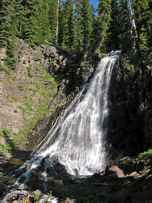
The Southern San Juan Mountains are one of Colorado's more remote places. There aren't any major citiers, infrastructure is hard to come by and most of the roads that penetrate into this wilderness area are forest service roads (though weirdly in good shape).
This is one of two of Colorado's wildest corners. A wild place that was carved eons ago by receding glaciers, elk herds are large here and ranchers use the lands for free-grazing cattle. At almost 159,000 acres, the South San Juan Wilderness is among the larger wilderness tracts. There are roughly 180+ miles of trails that weave, dance and cut through staggeringly dense forest and volcanic cliffs/peaks. It is also the location of the last confirmed grizzly bear sighting in 1979. Because of unconfirmed and unvalidated track sightings throughout the 1980's, there is a small portion of the local populace that still believes a small, reticent population exists undiscovered. As wild and undeveloped as this part of the country is, I can see why this belief persists. This is also a good place to potentially see wolverine, due to the same reasons.
Summit Peak is 29th among Colordo's most prominant peaks (2,737' prominance). Located in the Eastern San Juan Mountains, it is the highpoint of Archuleta County. Because of that, it would normally see a lot more visit's from people...if it wasn't for the fact that it's already fairlry isolated in an isolated area.
Summit Peak has two faces. While the southern slopes are resplendent with wildflowers and green tundra, the northern aspect hordes talus, scree and fractured cliffs. Fortunately, the Continental Divide National Scenic Trail (CDNST) runs the length of the entire eastern side. So it's easy to spring snow climb the northern side and walk off the southern side down mellow slopes.
The elevation gain from the standard trailhead is about 2,385' in about 3.6 miles (one-way). While the trail is easy to follow and quite good, chances are you will not encounter any other people. There are no other objectives accessed from this out and back trailhead other than the other local peaks which, also lie along the same ridge as Summit Peak. These other peaks are: "The Unicorn," Montezuma Peak, Point 12,636', Point 12,569' and Long Trek Mountain.
Getting There
From Del Norte: Start driving west out of town. As soon as you pass the Family Dollar on the right (drive the speed limit, this is a favorite spot for town cops to hangout), look for county road #14 (Pinos Road) on the left. Turn here and drive south. At 11.8 miles, you'll come to a junction with Pinos Creek Road. Stay to the right and continue south on an increasingly rougher road for 8.8 miles. Turn left onto Summitville Road and keep following generally south to the intersection with county road #243. This is a fairly sizeable intersection with #243 angling off at a sharp angle. Follow #243 to the end of the road, about 2.8 miles. This is the trailhead for Summit Peak, Montezuma Peak and Treasure Creek. Even though the county & mountain roads in Rio Grande County are generally, quite good, high-clearance vehicle is recommended.
From South Fork: Leave the small R.V. Mecca of South Fork heading west onto state highway #160. After 8.3 miles, turn left onto county road #380 (dirt road) passing Park Creek Campground. Drive for 23.5 miles to Lakes Annella and De Nolda. The road is rough and will take you an hour to 90 minutes. Make a sharp right onto county road #243 and follow for 2.8 miles to the end. The road isn't too bad. This will be the trailhead for Treasure Creek & Summit Peak. High-clearance vehicle is recommended
From Alamosa: Leave Alamosa heading south onto US 285. Drive for 3.5 miles to a four-way intersection with county road #370 (10-S). Turn right (west) and proceed for 16 miles to county road #15. Turn left (south) for an additional .3 miles. Then turn right on FSR #250 and drive west for 10.3 miles to Terrace Reservoir.
At the reservoir, stay straight and continue west on #250. Drive for ~18 miles to the intersection with FSR #380. At this intersection, is the Stunner Campground. It has its own entrance, look for it as a marker. Take #380 to Lakes Annella and de Nolda whereby, stay left onto county road #243 and follow this for the remaining 2.8 miles to the end of the road. This is your trailhead.
Camping
There aren't too many option to camp around Summit Peak that doesn't involve dispersed or car camping. But this one campground isn't too bad. I've personally stayed there and it wasn't too bad. Some areas still hold trash from past rude campers.
Stunner Campground- There is no fee when camping here...amazingly. The only gripe is bees can be a problem. Stunner Campground sits at 9700' beside the Alamosa River, two miles below the top of Stunner Pass. There are 5 campsites with tables, fire pits, a vault-type toilet, and adequate parking. There is no water supply, so plan to bring your own. Firewood is limited. Convenient trailer spaces available. The Alamosa River is nearby for fishing. Unfortunately, naturally acidic water severely limits fishing in the Alamosa River between Stunner Campground and Terrace Reservoir. The ghost town of Stunner is just east of the campground. This was a mining town that failed, due to nonproducing mines and transportation problems. Parts of the town are private property, so pack out all your trash and observe posted no-trespassing signs.
Red Tape
Summit Peak lies in the San Juan National Forest. Forest regulations are considerably more relaxed than wilderness. But in general, here are a few guidelines and rules for visits to national forests:
![]()
- Maximum stay of 14 days
- Follow current campfire restrictions
- No fireworks
- FIrearms (certain restrictions apply).
- Pets must be on a leash in developed areas
- Of course, leave no trace and pack out all trash.
Mountain Conditions/Weather


External Links