
-
 40482 Hits
-
 95.13% Score
-
 51 Votes
|
|
Area/Range |
|---|---|
|
|
46.15664°N / 10.49541°E |
|
|
Hiking, Mountaineering, Trad Climbing, Ice Climbing, Mixed, Scrambling, Via Ferrata, Skiing |
|
|
Spring, Summer, Fall |
|
|
11660 ft / 3554 m |
|
|
What's new on this page?
PAGINA COMPLETA DI TRADUZIONE IN LINGUA ITALIANA - THE ITALIAN TRANSLATION ADDED TO THE PAGE (2021, February)
Overview
Adamello Group
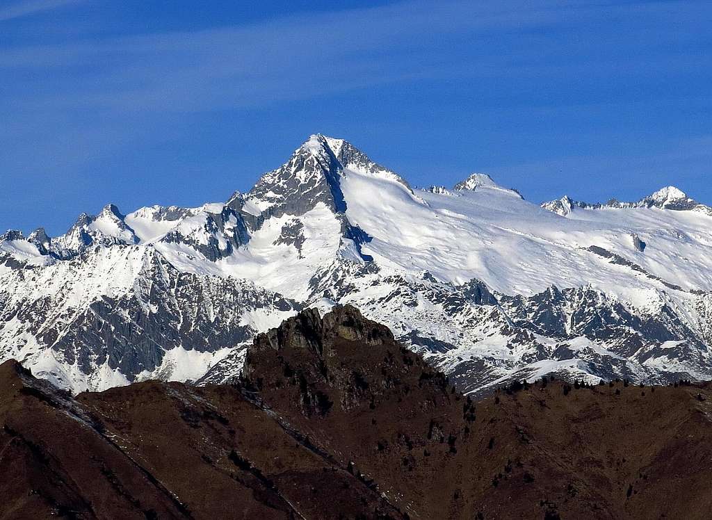
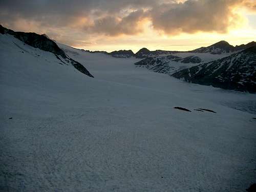
The Adamello Group is a mountain massif belonging to the Alpi Retiche Meridionali (Southern Rhaetian Alps), shared between the provinces of Brescia to the West and Trento to the East. From a geological point of view the group is mainly formed by intrusive volcanic rocks (diorite quarzifera called "tonalite" or "Adamello granite"). The group has an extensive glacial system with very impressive glaciers, so much so as to include some of the largest glaciers in the Alps, such as the Mandrone glacier. Other important glaciers are the Pian di Neve, the Lobbia glacier, the Adamello glacier, the Vedretta di Lares. Like the majority of the alpine glaciers, all the Adamello glaciers are living a phase of drastic withdrawal since several years.
The highest mountain is Adamello 3554 m, the main peak among several mountains inside the Adamello Natural Park, while the second highest peak of the group is Carè Alto 3463 m. The whole group of mountains around Monte Adamello take its name. Adamello offers an aureole conformation, therefore from the central glaciers of the culminating plateau start mountainous crests and chains which, in their turn, are integrated in the subgroups of the Baitone, Frisozzo and Blumone. Peaks, crests, mountains dominate the complex of numerous valleys spread all over the Park, so as to divide the several chains.
The Val di Genova divides the Adamello Group from the adjacent Presanella Group. Together with the nearby Presanella group, the Adamello group is a well-differentiated mountain chain within the Eastern Alps. In fact with their deep valleys, extensive glaciers and granite-like rock, both groups have a completely different morphology from the nearby Dolomiti di Brenta and the Dolomites in general.

Il Gruppo dell' Adamello è un massiccio montuoso appartenente alle Alpi Retiche Meridionali, condiviso tra le province di Brescia ad ovest e Trento ad est. Dal punto di vista geologico il gruppo è formato principalmente da rocce vulcaniche intrusive (diorite quarzifera detta "tonalite" o "granito dell'Adamello"). Il gruppo ha un vasto sistema glaciale con ghiacciai molto impressionanti, tanto da includere alcuni dei più grandi ghiacciai delle Alpi, come il ghiacciaio del Mandrone. Altri importanti ghiacciai sono il Pian di Neve, il ghiacciaio della Lobbia, il ghiacciaio dell'Adamello, la Vedretta di Lares. Come la maggior parte dei ghiacciai alpini, tutti i ghiacciai dell'Adamello da parecchi anni stanno attraversando una fase di ritiro.
La montagna più alta è l'Adamello 3554 m, la più importante tra le diverse montagne all'interno del Parco Naturale Adamello, mentre la seconda vetta più alta del gruppo è il Carè Alto 3463 m. L'intero gruppo di montagne attorno al Monte Adamello prende il nome della cima principale. L'Adamello presenta una conformazione a raggiera, quindi dai ghiacciai centrali del plateau culminante iniziano creste montuose e catene che, a loro volta, sono integrate nei sottogruppi di Baitone, Frisozzo e Blumone. Cime, creste, montagne dominano il complesso delle numerose valli sparse in tutto il Parco, così da dividere le varie catene.
La Val di Genova divide il Gruppo Adamello dall'adiacente Gruppo della Presanella. Insieme al gruppo Presanella, il gruppo Adamello è una catena montuosa ben differenziata all'interno delle Alpi Orientali. Infatti, con le loro profonde vallate, i vasti ghiacciai e la roccia granitica entrambi i gruppi hanno una morfologia completamente diversa dalle vicine Dolomiti di Brenta e dalle Dolomiti in generale.

The borders of the Adamello group are:
- Valcamonica, the Western (from Lovere to Edolo) and Northern (from Edolo to Tonale pass) border of the group
- Le Giudicarie, the eastern border of the group ( from Ponte Caffaro to Pinzolo) To its south side the Adamello group doesn't have a definite border and can be considered as divided from Prealpi by the road of Passo di Croce Domini, joining Breno (Val Camonica) with Bagolino and Lodrone (the starting point of Giudicarie).

Adamello main ridges, subgroups and ranges - starting from North:
- Venerocolo, between the Tonale, Presena and Garibaldi passes
- Adamello massif, the central hub between the Garibaldi, Prudenzini and Adamello passes
- Baitone subgroup, starting toward West from Passo Prudenzini
- Miller chain, starting from Passo dell'Adamello toward south-west
- Salarno chain, starting from Passo di Salarno toward south-west
- Génova chain, starting from Passo dell'Adamè toward north till the Passo della Lobbia Bassa
- Levade chain, starting from Passo dell'Adamè toward south - the long ridge ends, in its southern part with the subgroups of Re di Castello, Frisozzo, Tredenus and Blumone
- Carè Alto group, the long easternmost ridge of the group - east of Passo della Lobbia - to the south, after the Passo di San Valentino, the ridge becomes the
- Breguzzo group
I confini del gruppo dell' Adamello sono:
- la Valcamonica, il confine occidentale (da Lovere a Edolo) e settentrionale (da Edolo a Tonale) del gruppo
- le Valli Giudicarie, il confine orientale del gruppo (da Ponte Caffaro a Pinzolo). All'estremità sud il gruppo dell'Adamello non ha un confine definito e può essere considerato come separato dalle Prealpi Bresciane dalla strada del Passo di Croce Domini, che mette in comunicazione Breno (Val Camonica) con Bagolino e Lodrone (punto di partenza delle Giudicarie).
Le principali creste, sottogruppi e catene dell'Adamello - a partire da Nord sono:
Nodo del Venerocolo - tra il Tonale e i Passi Presena e Garibaldi
Il Massiccio dell'Adamello - nodo centrale - tra i passi Garibaldi, Prudenzini e Adamello
Sottogruppo del Baitone - si dirige verso ovest dal Passo Prudenzini
Catena di Miller - si dirige verso Sud-Ovest dal Passo dell'Adamello
Catena di Salarno - si dirige verso Sud-Ovest dal Passo di Salarno
Catena Génova - si dirige verso Nord dal Passo dell'Adamè fino al Passo della Lobbia Bassa
Catena delle Levade - si dirige verso Sud dal Passo dell'Adamè - questa lunga cresta termina, nella sua parte meridionale, con i sottogruppi di Re di Castello, Frisozzo, Tredenus e Blumone
Gruppo Carè Alto - la cresta più orientale del gruppo, a Est di Passo della Lobbia; verso Sud, dopo il Passo di San Valentino, la cresta diventa il gruppo Breguzzo

|

|
Main peaks
The main peaks of the Adamello group in order of height -
Le principali vette del Gruppo Adamello in ordine di altezza:
Adamello 3539 - Carè Alto 3463

|

|
Corno Bianco 3427 - Monte Fumo 3418 - Corno di Cavento 3402

|

|
Corno Miller 3373 - Crozzon di Lares 3354 - Punta del Venerocolo 3323 - Monte Folletto 3312 - Monte Mandrone 3294 - Monte Venezia 3290 - Monte dei Frati 3284 - Corno dell’Adamè 3275 - Cima Garibaldi 3237 - Cima Calotta 3225

|

|
Corno di Bedole 3221 - Lobbia Alta 3196 - Cima Plem 3179 - Corno Pian di Neve 3176 - Corni di Lago Scuro 3166

Getting There
Adamello Natural park can be approached from Lombardia or Trentino Italian regions:
By car the Park can be reached using:
- a) the state roads coming from Brescia and Bergamo; they combine near Darfo Boario Terme in to the only state road of the Mendola, which is near the western limits of the Park from Breno till the Tonale;
- b) the state road coming from Valtellina to Edolo, through Aprica;
- c) the state roads coming from Bolzano, through the road of the Mendola, and from Trento, through Cles and Malé, which reach the Park at Tonale Pass.
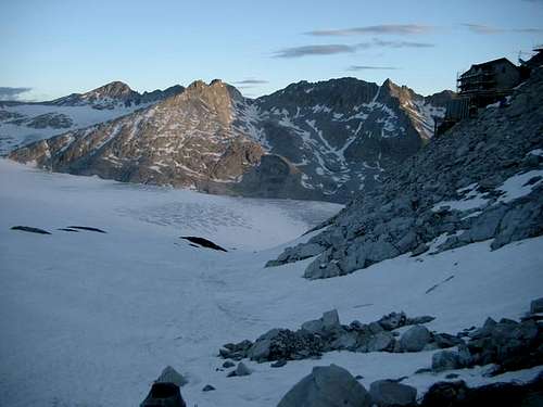
In order to know more about the Park's wonders, in all its amazing natural and environmental aspects, it's necessary to walk on foot inside it. In the last years, nearly all the natural roads and numerous paths have been brought into use with appropriate guiding signs to assist tourists; as for paths (a network of almost 1000 km), they are capable of satisfying any kind of need, from the simple family hike along tracks through the woods, to the thrilling and demanding alpine ascents at high altitudes, perhaps including the crossing of the legendary Pian di Neve.
Among the paths, one can be easily appreciated, that one indicated as Number 1 or "Adamello High Trail", about 50 km long, crossing the Park to its extent. For an ascent in the high mountain territories, it is useful to be prepared with heavy clothes in case of unexpected bad weather (heavy boots, fleece clothing, soft shells, topographical map or GPS).
To the Rifugio Bedole (the start for several trekking and climbs in the area) you have to reach the village of Carisolo (situated along the state road 239 between Pinzolo and Madonna di Campiglio) and turn left when you look the signpost "Val Genova". The 17-kilometer carriage road that runs through the Val di Genova starts in Carisolo, separating from the Campiglio state road 239. The road ends near the Refuge Bedole 1584 m. During the summer months (generally from 15 June to 15 September) the practicability of the road is subject to limitations:
- the first 4 km, from Carisolo to Ponte Verde are freely passable. There are free parking lots along the street.
- the next 4.5 km from Ponte Verde to Ponte Maria are accessible by paying a toll (€ 3.00 for motorbikes; € 8.00 for cars) which also allows you to park on the subsequent parking lots.
- the last 7.5 km from Ponte Maria to the Refuge Bedole are normally accessible only at the beginning of the day (usually before 9.45 am and after 6.00 pm).
During the summer, a paid shuttle service runs along the toll section (Ponte Verde - Malga Bedole), with services running approximately every half hour.
In winter the road is normally closed before the Nardis waterfall, sometimes immediately after the Alla Prisa bar-restaurant.
a) le strade statali provenienti da Brescia e Bergamo; confluiscono nei pressi di Darfo Boario Terme nell'unica strada statale della Mendola, che si trova vicino ai limiti occidentali del Parco da Breno fino al Tonale;
b) la strada statale proveniente dalla Valtellina per Edolo, attraverso Aprica;
c) le strade statali provenienti da Bolzano, attraverso la strada della Mendola, e da Trento, attraverso Cles e Malé, che raggiungono il Parco al Passo del Tonale.
Per conoscere meglio le meraviglie del Parco, in tutti i suoi sorprendenti aspetti naturali e ambientali, è necessario camminare a piedi al suo interno. Negli ultimi anni, quasi tutte le strade naturali e numerosi percorsi sono stati utilizzati con opportuni segnali guida per aiutare i turisti; per quanto riguarda i sentieri (una rete di quasi 1000 km), sono in grado di soddisfare qualsiasi tipo di esigenza, dalla semplice escursione familiare lungo i sentieri attraverso i boschi, alle emozionanti e impegnative salite alpine in alta quota, forse compreso l'attraversamento del leggendario Pian di Neve.
Tra i percorsi si può facilmente apprezzare quello indicato con il numero 1 o "Alta Via dell'Adamello", lungo circa 50 km, attraversando il Parco nella sua estensione. Per una salita nei territori di alta montagna, è utile essere preparati con abiti pesanti in caso di maltempo inaspettato (stivali pesanti, abbigliamento in pile, conchiglie morbide, mappa topografica o GPS).
Per il Rifugio Bedole (l'inizio di numerosi trekking e arrampicate nella zona) bisogna raggiungere Carisolo (situato lungo la strada tra Pinzolo e Madonna di Campiglio) e svoltare a sinistra alla tabella "Val Genova". La strada carrozzabile di 17 chilometri che percorre la Val di Genova inizia a Carisolo, staccandosi dalla Strada statale 239 di Campiglio. La strada termina presso il Rifugio Bedole 1584 m. Durante i mesi estivi (generalmente dal 15 giugno al 15 settembre) la percorribilità della strada è soggetta a limitazioni:
- i primi 4 km, da Carisolo fino a Ponte Verde sono percorribili liberamente. Sono presenti parcheggi gratuiti lungo la strada.
- i successivi 4,5 km, da Ponte Verde a Ponte Maria sono accessibili pagando un pedaggio (3,00 € per le moto; 8,00 € per le auto) che dà anche diritto a sostare nei successivi parcheggi.
- gli ultimi 7,5 km da Ponte Maria al Rifugio Bedole sono normalmente accessibili solo a inizio giornata (solitamente entro le 9.45 e dopo le 18.00).
Durante l'estate lungo il tratto a pagamento (Ponte Verde - Malga Bedole) è attivo un servizio di bus navetta a pagamento, con corse ogni mezz'ora circa.
D'inverno la strada è normalmente chiusa prima della cascata di Nardis, talvolta subito dopo il bar-ristorante Alla Prisa.
|
|
The World War I (The White War)

During the First World War the western end of the italian-austrian front crossed two important and high mountain chains, Ortles-Cevedale and Adamello-Presanella. The two armies where forced to fight, for more than three and a half years, a typical alpine war, fought on rocks and glaciers often at altitudes above 3000 meters and in very difficult weather conditions.
Living at those heights was itself a problem for the soldiers: winter lasted eight months without interruption, there were copious snow falls starting from October till May and often the snow reached heights of several meters. The cold, an implacable daily enemy, varied in this period between -10° and -15° with night drops between -20° and -25° and lower. In this "white hell", italian and austrian soldiers, besides fighting each other, had to survive the extreme environmental conditions. Among such the implacable and deadly avalanches that, compared to the combat, caused more victims. On the Adamello every action throughout the years, aimed mainly at unhinging, directly or not, the austrian caposaldo of Monticelli, so as to free the way through the Tonale Pass.
The Austrians had arranged for trenchs and dug numerous caverns along the front line that connected the Monticelli to the eastern Tonale altitudes. Furthermore they had also occupied the Paradiso Pass, Castellaccio Pass and Lagoscuro Pass that dominated the plateau of Ponte di Legno.

|

|

|
Durante la Prima Guerra Mondiale l'estremità occidentale del fronte italo-austriaco attraversò due importanti catene montuose: l'Ortles-Cevedale e l'Adamello-Presanella. I due eserciti si trovarono a combattere, per più di tre anni e mezzo, una tipica guerra alpina, fronteggiandosi su rocce e ghiacciai spesso ad altitudini superiori ai 3000 metri e in condizioni climatiche molto difficili.
Vivere a quelle quote era già di per sé un'ardua impresa per i soldati: l'inverno durava otto mesi senza interruzione, c'erano copiose nevicate a partire da ottobre fino a maggio e spesso la neve raggiungeva altezze di diversi metri. Il freddo, un implacabile nemico quotidiano, variava in questo periodo tra -10 e -15 gradi, con punte notturne tra -20 e -25, a volte anche più basse. In questo "inferno bianco", i soldati italiani e austriaci, oltre a combattere tra loro, dovettero sopravvivere a queste condizioni ambientali estreme. Tra esse le valanghe, implacabili e mortali, che rispetto al combattimento causarono un maggior numero di vittime. Nel gruppo dell'Adamello ogni azione intrapresa dall'esercito italiano nel corso degli anni era volta principalmente a scardinare, direttamente o meno, il caposaldo austriaco di Monticelli, in modo da liberare la strada attraverso il Passo del Tonale.
Gli austriaci avevano predisposto trincee e scavato numerose caverne lungo la linea del fronte che collegava il Monticelli alle altitudini del Tonale orientale. Inoltre avevano occupato anche il Passo del Paradiso, il Passo del Castellaccio e il Passo del Lagoscuro che dominava l'altopiano di Ponte di Legno.
Huts

Rifugio Adamello Collini "Al Bedole" 1640 m 38080 Strembo (Tn) - Val Genova - Italy Telephone: +390465501405. Fax: +390465502325

Rifugio Ai Caduti dell'Adamello Located at 3040 m. of altitude near Lobbia Alta Pass between the glaciers of Mandrone and Lobbia. N° 90 beds available. The managing is entrusted to Martino Zani, tel. 0364/92655. Tel refuge 0465/52615.

Rifugio Aviolo 1930 m Situated near Lake Aviolo. 60 beds available. The managing is entrusted to Simona Zani - Hut phone 0364/76110
Rifugio Baita Adamè Situated in Valle Adamè. 40 beds available. The managing is entrusted to the Associazione Gruppo Baita Adamè
Rifugio Città di Lissone 2020 m Situated in Valle Adamé. Located at the beginning of Adamé Valley, at the foot of the north wall of Corno di Grevo. It has 70 beds available, carries out hotel service from the middle of june to the middle of september, winter bivouac always open. It is property of the CAI Lissone, tel. 069/461770. The managing is entrusted to the alpine guide Ferri Domenico (via Fontane, 39 - Saviore Valley - BS - tel. 0364/638232). Tel. refuge: 0364/638296.

Rifugio Tonolini 2450 m The refuge “Franco Tonolini” at Baitone is situated in the middle of the Baitone Basin near lake Rotondo. Carries out hotel service from the middle of june to the middle of september, 36 beds available. Winter place always open. It is property of the CAI of Brescia, tel. 030/48426. The managing is entrusted to Fabio Madeo. The refuge has a telephone 0364/71181
Rifugio Garibaldi 2550 m Situated on Venerocolo, at the foot of the North wall of the Adamello near lake Venerocolo. Carries out hotel service from the middle of june to the middle of september, with 100 beds in small and larger rooms. Winter place always open. It is property of the CAI of Brescia, tel. 030/48426. The managing is entrusted to Odoardo Ravizza - Hut phone: 0364/906209.
Rifugio Maffeo Gheza 2087 m in locality Foppe Alte di Braone. 30 beds available. The managing is entrusted to the CAI of Lovere tel.0364/52674
Rifugio Maria e Franco 2574 m on Passo Dernal. Located on a pass, it dominates the Valle Dois, one of the most characteristic valleys of the Parco Adamello. With 45 beds available offers hotel service from the middle of june to the middle of september, winter bivouac always open. It is property of the CAI of Brescia, tel. 030/48426. The managing is entrusted to Massussi Giacomo (Via Di Vittorio 29, 25019 Colombare di Sirmione tel 030/9196647). The refuge has a telephone 0364/634372.

Rifugio Paolo Prudenzini 2225 m in Val Salarno. Located in the northern area of Salarno Valley. 86 beds available. Offers hotel service from the middle of june to the middle of september. Winter bivouac always open. It is property of the CAI of Brescia tel. 030/48426. The managing is entrusted to Gelmini Marco (via Verdi, 35 - Ponte di Saviore dell'Adamello - BS tel. 0364/634261). Refuge tel. 0364/634578
Rifugio Serafino Gnutti 2166 m. Located in Val Miller, eastern of Val Malga, near the homonym lake. 34 beds available, carries out hotel service from the middle of june to the middle of september, winter bivouac always open. It is property of the CAI of Brescia, tel. 030/48426. The managing is entrusted to Maria Domenica Madeo Fiorani (via Europa, 132 - Concesio - BS - tel. 030/2751226). Contact at Rino di Sonico tel. 0364/75107. The refuge has a telephone 0364/72241
Rifugio Tita Secchi 2367 m at Lago della Vacca. Located at the foot of the southern wall of the Cornone di Blumone, near Lake Vacca, has 60 beds available. Offers hotel service from june to october; on request during the closing period, the refuge can be opened to groups. Winter bivouac, keys from the guardians of the dam. It is property of the U.Ugolini society of Brescia tel. 030/3753108. The managing is entrusted to the alpine guide Baccanelli Giacomo (via Fandrissa, 25040 - Niardo- BS tel. 0337/441650). Tel. Refuge 0365/903001.

Rifugio Carè Alto - Dante Ongari Situation: East ridge of Carè Alto, on the side of Val Conca (Val di Borzago) Open: from June 20th to September 20th Size: 82 persons Winter-shelter: 8 persons Owner: SAT Trento Guardian: Marco Bosetti and family Refuge's phone: +39 348 4359097 - +39 340 2943731
Approach - From Pelugo or from Borzago in Val Rendena drive up Val di Borzago. Parking lot Pian della Sega in Val di Borzago (m 1250). Here take the old mule track through the woods and follow it until the alp Coel di Pelugo 1440 m. (30 minutes) from where it starts the cable car to the refuge. Take the path SAT 213 rising along steep turns, reach a tibetan bridge on a stream (rio Bedù di Pelugo), cross it and rise to the plateau above, traverse left and walk up the large rocky step, getting to the refuge (3,30 hours from Pian della Sega, difference in level 1200 m).

Rifugio Val di Fumo Situation: Val di Fumo Approach - From Praso follow the road to Val Daone (23 km) till Lago di Malga Bissina (car park) and then continue on foot along the path n. 240 to the refuge (1.30 hours).
Bivouacs
")
|
")
|
The Adamello Group counts several bivouacs. Here a list of the main ones:
CAI Macherio 2590 m (Tredenus)
Gualtiero Laeng 3191 m (Passo di Cavento)
Giannantonj 3168 m (Passo di Salarno)
Eugenio Segalla 3050 m (Passo delle Vacche)
Zanon - Morelli 3149 m (Passo Brizio)
Amici della Montagna-Faustinelli 3166 m (Corni di Lagoscuro)
Valerio Festa 2330 m (Passo Gallinera)
Ceco Baroni 2800 m (Cima delle Levade)
Ugolino Ugolini 3240 m (Passo dell'Adamello)
Francesco Regosa 2958 m (Bocchetta della Calotta)
Capanna Mattia 2612 m (Cima Monoccola)
Red Tape
 |
 |
Nessun costo, nessun permesso necessario e nessuna restrizione particolare per l'arrampicata e l'escursionismo. Il Gruppo dell'Adamello è situato all'interno del Parco Naturale Adamello-Brenta, la più vasta area protetta del Trentino, istituita nel 1967. Si trova nel Trentino occidentale e con i suoi 620,51 chilometri quadrati comprende i gruppi montuosi dell'Adamello, della Presanella e delle Dolomiti di Brenta, separati dalla Val Rendena. Sul versante lombardo si trova il Parco dell'Adamello, che si estende per 510 chilometri quadrati sul versante orografico sinistro della Valle Camonica, nella porzione nord-orientale della Provincia di Brescia. Il campeggio non è consentito e i fuochi sono severamente vietati.
Geology, fauna, flora
The shape of the mountains in the Adamello massif has been largely shaped, as well as by the erosion of atmospheric agents, by the action of the great glaciers. Unlike the other mountainous complexes of sedimentary origin belonging to the Eastern Alps, the type of rock found in the Adamello massif has an intrusive origin. The crystalline and impermeable nature of the rocks and the presence of conspicuous glaciers produces abundance of springs and watercourses. The main types of magmatic rocks present are:
- quarzodiorites
- granodiorites
- tonalities
In the Adamello group thanks to the wildness of the region there is a rich alpine fauna including also the brown bear. In the lower altitudes, between 600 and 1800 meters, the deer and the roe deer live on the edge of the mixed deciduous and coniferous forests, while the chamois live beyond the limits of the vegetation in a few flocks. Beyond the limit of the arboreal vegetation it is in fact possible to observe in addition to the chamois (Rupicapra rupicapra) also the ibex (Capra ibex). Due to the recent reintroduction, the Ibex is now also present inside the Adamello massif. Both the species, as known, prefer the rocky ground.
La conformazione delle montagne del massiccio dell'Adamello è stata in gran parte modellata, oltre che dall'erosione degli agenti atmosferici, dall'azione dei grandi ghiacciai. A differenza degli altri complessi montuosi di origine sedimentaria appartenenti alle Alpi Orientali, il tipo di roccia rinvenuta nel massiccio dell'Adamello è mdi origine intrusiva. La natura cristallina e impermeabile delle rocce e la presenza di grandi ghiacciai determina abbondanza di sorgenti e corsi d'acqua. I principali tipi di rocce magmatiche presenti sono:
- quarzodioriti
- granodioriti
- tonaliti
Nel gruppo dell'Adamello grazie alla natura selvaggia di questo gruppo, è presente una ricca fauna alpina tra cui anche l'orso bruno. Nelle quote più basse, tra i 600 e i 1800 metri, il cervo e il capriolo vivono ai margini dei boschi misti di latifoglie e conifere, mentre i camosci vivono in pochi branchi oltre i limiti della vegetazione. Al di sopra del limite della vegetazione arborea è infatti possibile osservare oltre al camoscio (Rupicapra rupicapra) anche lo stambecco (Capra ibex). A causa della recente reintroduzione, lo Stambecco è ora presente anche all'interno del massiccio dell'Adamello. Entrambe le specie, come noto, prediligono il terreno roccioso.
A suggestion to climb Adamello, the highest mountain of the group

FIRST DAY:
Refuge Bedole (1600 meters) to Ref. Mandrone (2480 m) - path n. 212, h 2,30 (E) Then to Refuge Ai Caduti dell'Adamello - Lobbia Alta (3030 m) - h 3, last part on the glacier. Sleep here.
SECOND DAY:
From Refuge Ai Caduti dell'Adamello - Lobbia Alta (3030 m) to Monte Adamello (3554 m) - 5 hours. Then to Refuge Mandrone (2480 m) and Refuge Bedole (1600 m) - 7 hours.
Meteo
Meteo Trentino
Meteo ARPA Lombardia
Guidebooks and maps
-Guidebooks
"Adamello" Vol. I - Pericle Sacchi - Collana Guide dei Monti d'Italia CAI-TCI
"Adamello" Vol. II - Pericle Sacchi - Collana Guide dei Monti d'Italia CAI-TCI
 |
 |
-Maps
"Adamello - Presanella" - Tabacco scala 1:25000
"Adamello, Val di Fumo, Val di Genova" - Kompass n. 638
"Adamello - Presanella" - 4LAND Alpine Cartography n. 138 1:25.000
External Links
- Sentiero numero 1 - Alta Via dell'Adamello