
-
 44984 Hits
-
 94.02% Score
-
 45 Votes
|
|
Area/Range |
|---|---|
|
|
40.75670°N / 3.87000°E |
|
|
Hiking, Mountaineering, Trad Climbing, Sport Climbing, Toprope, Bouldering, Aid Climbing |
|
|
6909 ft / 2106 m |
|
|
Overview
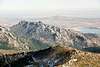
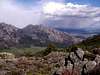
La Pedriza de Manzanares is a granitic low range located to the south of Sierra de Guadarrama. So it connects to the N with Cuerda Larga (Peñalara), between Cabezas de Hierro and Najarra. A long ridge called Cuerda del Hilo o de los Porrones springs from La Maliciosa (NW) and reach near the village of Manzanares el Real (908 m). That cuerda (ridge) is to the right (W) of Río Manzanares (the same that crosses Madrid), wich limits La Pedriza along some kilometers. The road M-608 also marks the most southern border. To the E, Hoya (basin) de San Blas, Arroyos (creeks) de Santillana and Chico are placed.So the N border of La Pedriza marks the highest point, Peña Linderas (2.106 m). Wich is different from the most elevated mountain (Cabeza de Hierro Mayor - 2.381 m) of Parque Regional de la Cuenca Alta del Manzanares, where La Pedriza is included. High detailed maps as La Pedriza de Manzanares 1:15.000 (La Tienda Verde, 2007) show 2.109 m as the elevation of Peña Linderas. In the 19th century La Pedriza was a hiding place of the famous bandoleers. On October 12th, 1930, the zone had been declared Sito Natural de Interés Nacional. In 1978 the surface was extended including the high valley of Manzanares river, so it was first named Parque Natural de la Cuenca Alta del Manzanares. The Regional Park was created on January 23rd, 1.985 and has had many enlargements since then. Now it has 46.728 Ha / 115,467 acres, wich is 6.25% of the Madrid province. Actually the ecological importance is internationally recognized because on November 9th, 1992 it was declared Reserva de la Biosfera by UNESCO.
La Pedriza is formed by 3 different units: el Alcornocal, la Pedriza Anterior and la Pedriza Posterior. El Alcornocal is the lowest part, it's near Manzanares el Real and separated to the N from Pedriza Anterior by Collado de la Cueva. The massif over the village that rises to Peña del Yelmo (1.717 m) is named La Pedriza Anterior. La Pedriza Posterior is semicircular shaped and placed to the N of Anterior, that's why it's also called Circo de la Pedriza.
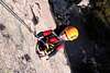
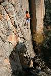
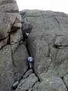
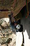
In La Pedriza there are not only many hundreds (1800) of sport climbing routes but also lots of classics, beeing one of the most known granite rock climbing spots of Spain.
 |  |  |  |  |
Getting There
PlaneThe nearest city to La Pedriza is Madrid, wich has the Barajas International Airport.
Private vehicle
There are two important bases for approaching La Pedriza, el Tranco and Canto Cochino. El Tranco (960 m) is a little plain near Manzanares el Real wich is surrounded by houses. Canto Cochino (1.025 m) is a parking in the heart of La Pedriza, its name comes from the so called rock wich is behind the bar.
From Madrid (49 Km) take the road C-607, M-862 for 2 Km, C-608 to Manzanares el Real and finally take the street to the right, just after the village (don't take the ring road and neither cross the bridge), for reaching el Tranco in less than 3 Km. Canto Cochino is reached taken the narrow road (to the righ) 1 Km passed Manzanares el Real. Cross the natural park fence (Centro de Interpretación is 200 m before), ascent to Puerto de Quebrantaherraduras and descent to the parking.
From the W take A-6 to Collado Villalba, M-608 and then as "From Madrid" knowing that you come from the other side.
From the N take A-1 to Venturada, M-608 to the right and as "From Madrid".
Get informed of winter road conditions in pages 601 and 611 of "Teletexto" TVE.
Bus
The bus station in Madrid is in Plaza Castilla. The name of the company is Autobuses Colmenarejo. Tel: 91 845 00 51. Timetable
 |  |  |  |  |
Red Tape
No permits or summit fees are required to climb in La Pedriza but there are some rules for wildlife conservation you must observe due to La Pedriza is inside a nature reserve. Just get informed in Centro de Educación Ambiental del Parque Regional de la Cuenca Alta del Manzanares, placed in Camino de la Pedriza, Manzanares el Real, Madrid. Tel: 91 853 99 79. Open all days from 10 AM to 6 PM. |  |  | 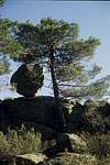 |
When To Climb
Anytime is good for climbing or hiking in La Pedriza. Some days in winter could be rainy, snowy and foggy. So be careful because it's very easy to get lost in La Pedriza. In July and August climb in the shadow, otherwise you'll be burnt in few hours.INM weather forecast for Sierra de Guadarrama and Somosierra.
 |  |  |  |  |
Camping
All the routes can be attempted in a day but, if you want to spend the night in the area, the best way is bivouacing preferably out of winter months. Camping is forbidden in the whole park and all over Madrid province. So you may pass the night in the artificial bivouacs near Canto Cochino or in the Covacho de la Majada de Quila wich is a natural bivy.HUTS
Refugio Giner de los Ríos (1.220 m)
This hut is over Prado Peluca (1.175 m) and near Canto del Tolmo. It was built in 1916 and belongs to R.S.E.A Peñalara, offers food, water, light, beds (50 places in bunks), blankets and bar. It's open in weekends (including fridays), holidays and when it's reserved. Don't have telephone, WC or non-guarded places. Our summitposters "losdestroy" announce that Guzmán García is now the guardian of the refuge since 7 years ago. His phone number is 659 02 17 54. R.S.E.A Peñalara phone number is 91 522 87 43. Other possible numbers: 91 856 68 62 and 608 812 120. Prize ('04) with breakfast: 17 euro. Another site
The easiest approach to the refuge is from Canto Cochino. Cross the river Manzanares on a little wooden bridge. Surround some houses and continue on a good trail (GR 10) through the pinewood. After 100 m turn right and reach the shore of Arroyo (creek) de la Majadilla. The trail do a zig zag (20 min) for saving a slope and then turn flat. Leave another trail (goes to Collado del Cabrón) to the left and descent a little. There is a bifurcation but our path is the one to the right, the other goes to Circo de la Pedriza. Cross a little wooden bridge, traverse a meadow and reach the hut (30 min). Some meters below there is a drinking fountain called Fuente Acuña.
 |  |
Foremost peaks and rocky formations
El AlcornocalAlcornocal (1.136 m) and Miramar (1.146 m).
Pedriza Anterior
Acebo (1.626 m), Aguja Larios (1.353 m), Altos de Medina, Bola de San Antonio (1.636 m), Caballeros, Camello, Campana, Cancho Butrón (1.277 m), Canco de la Lagunilla (1.528 m), Cancho de las Pilas (1.572 m), Cancho de los Brezos (1.267 m), Camello (1.453 m), Cantocochino, Caperucita (1.604 m), Cara (1.579 m), Castillete (1.152 m), Castillo (1.462 m), Centinela, Cerro del Jaralón (1.469 m), Cinco Cestos, Cuatro Damas (1.563 m), Cueva de la Mora, Dinosaurio, Elefantito del Yelmo (1.582 m), Elefantito (1.424 m), Falso Acebo (1.594 m), Familia (1.079 m), Foca, Gran Cañada, Hoz Cimera, Hueco de las Hoces, Hueveras, Indio, Máquina, Maza (1.657 m), Mirador del Tranco (1.296 m), Muralla China, Ofertorio, Pan de Kilo (1.596 m), Peñas Cagás (1.455 m), Peña del Mediodía (1.214 m), Peña Sirio (1.378 m), Perra Gorda (1.291 m), Placa Angular (1.376 m), Placas del Halcón, Placas del Tranco, Placas Musgogénesis, Pradera del Yelmo, Punta Blanquita, Reloj, Risco de la Fuente (1.587 m), Risco de las Bellotas, Risco de las Tres Puntas (1.264 m), Risco del Hueco (1.506 m), Risco del Jamón, Risco de los Martes, Risco de los Principiantes, Risco del Trueno, Risco Sin Nombre, Rocódromo (1.227 m), Rompeolas (1.652 m), Techo, Tolmo (1.258 m), Torre Inclinada (1.421 m), Torre Valentina, Tortuga (1.264 m), Tranvía, Tres Coronas, Yelmo (1.716 m).
Pedriza Posterior
Aguja del Sultán (1.744 m), Aguja Singer, Alto de Matasanos (2.057 m), Arteria, Bola de Navajuelos (1.689 m), Bota (1.901 m), Buitreras (Primera 1.469 m, Segunda 1.452 m, Tercera, Cuarta and Quinta), Caballo de Ajedrez (1.759 m), Cáliz (1.278 m), Campana (1.554 m), Cancho Amarillo, Cancho Buitrón (1.646 m), Cancho Centeno (1.909 m), Cancho de los Gavilanes, Cerro de los Hoyos (1.950 m), Cancho de los Muertos (1.362 m), Canchos de los Gavilanes (2.012 m), Carro del Diablo (1.607 m), Castillete, Cocodrilo, Charca Verde, Cuatro Cestos (1.572 m), Damas, Dante (1.339 m), Dos Torres (1.771 m), Elefante (1.339 m), Esfinge (1.949 m), Falsa Bola (1.686 m), Falsa Buitrera (1.552 m), Falsa Muela, Galisol (1.533 m), Gran Molondrio, Guerreros (1.589 m), Hermanitos, Hueso, Laberinto*, Llamas, Mataelvicial, Milanera (1.792 m), Mogote de la Dehesilla (1.503 m), Mogote de los Suicidas, Moro (1.797 m), Muela, Nieves, Normando, Oseras, Pajarito, Pájaro (1.549 m), Pared de Santillana (1.824 m), Peña del Rayo, Peña Horcajo (1.354 m), Peña Linderas (2.106 m), Pequeño Molondrio (1.609 m), Platillo Volante, Puente de los Pollos, Punta Carmen, Puro, Risco de las Nieves, Risco de San Pedro (1.716 m), Risco del Gargajo, Risco del Puente (1.619 m), Risco Matute, Risco Moreno (1.694 m), Tolmete, Tolmo, Torre de las Arañas Negras (1.606 m), Torre de los Buitres (1.829 m), Torre de Quila (1.564 m), Torres (2.033 m), Torro, Tres Cestos (1.783 m), Tres Hermanitos (Primero, Segundo and Tercero 1.789 m), Vela, Ventana (1.808 m), Ventanillo (1.929 m), Zona Sioux.
*More peaks and rocky formations of El Laberinto: Aguja Pollastrón, Balcón Oscuro, Capuchino, Risco del Buitre, Cancho de las Oserillas, Risco del Mudo, Puro Nervio, Delirium Tremens, Risco Cuestolotrónico, Risco Matrizolándico, Risco de la Empanadilla, Espolón Extrema Unción, Risco del Loco, Risco de San Vito, Risco del Botijo, Teófilo and Risco Tocho.
 | 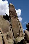 |  |  |  |
El Yelmo (1.716 m)
It's the highest crag in La Pedriza Anterior and provides the best views of the area. Maps as La Pedriza 1:25.000 (Alpina, 2004-2005) show 1.719 m as the height of El Yelmo. The historic climber Constancio Bernaldo de Quirós said about El Yelmo: Covering 1 square hectare (2.47 acres), it raises 175 m over the base on the S side and 95 m on the N, wich is exactly the maximum height of Monasterio de El Escorial. In 1992 it had 75 rock-climbing routes. In geology this peak has the form of a dome, wich is a vaulted rocky formation. They are little degraded when they're made of granite. Corcovado is a well known dome placed near Río de Janeiro (Brazil). The name yelmo (a special helmet) is because the similarity with that chivalry element. It's been called yelmo since 1350, when it's quoted in "Libro de Montería" by Alfonso XI. Formerly it was called Peña del Diezmo, in relation to a legend that about tributes payment. Many maps still show Diezmo but it's better known as Yelmo.El Yelmo was the first climbed crag in La Pedriza, by Casiano de Prado before 1864. Casiano climbed El Yelmo following the normal route of the N face. Nevertheless, it seems that it could be climbed before by shepherds or other people, because the climb on the N face is easy. On June 4th, 1916, the first summit box of the whole Sierra de Guadarrama was installed on the top of El Yelmo.
In May 1918, José F. Zabala, Emilio Vicente Arche, Rafael Fernández Aguilar, Eduardo Jimeno and José María Galán climbed the fist route on the S face. They ascended on the right shoulder (Gendarme), traversed from the upper section to the hollow at the right of the summit. The route was named "Eduardo" and was difficult in the first pitches. It's now graded IV+. In 1965-6 los Vikingos (Julio, Tino and "El Culebras") aid climbed the big granite slab of the S face. They put many burins and actually the route is very degraded so it's very difficult. The route: "Los Vikingos" (A1/IV+). In the mid 70s Daniel Guirles and Luis Campos first free climbed the slab of the S face opening "Guirles Campos" (6a+), one of the most beutiful routes of La Pedriza. In 1992 the S face of El Yelmo had 54 routes.
Rafa Bartolome has posted El Yelmo page here in SP.
 |  |  |  |  |
El Tolmo (1.258 m)
The name comes from the word tormo wich means terrón, lump in English. It's the biggest given off rock in Sierra de Guadarrama, its size is 16-18 m / 17.50-19.69 yd high and 73 m / 79.83 yd in circunference. The volume is 176 cubic meters / 230.2 cubic yards and the approximated weight, 500 Tn / 492.1 long tons. C. de Prado says in his "Descripción Física y Geológica de la provincia de Madrid" book that El Tolmo fell from a gap just to right of Risco del Pájaro. From Refugio Giner de los Ríos take the trail (GR 10) NE wards to Collado de la Dehesilla (1.453 m), seen in the background. The trail is in a slight ascent and crosses the slope. Leave a drinking fountain to the right and reach El Tolmo in 20 minutes from the hut.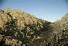 |
Advisable rock climbing routes
Grade IVEspolón (IV) - Peña Sirio
Walkiria (IV) - El Yelmo
Sur Clásica (IV) - Pared de Santillán
Hermosilla (IV+) - El Yelmo
Gran diedro (IV+) - Risco de los Principiantes
Guru Guru (IV+) - Platillo Volante
Grade V
Diedro norte (V-) - Cancho de los Muertos
Vía sur (V) - Pajarito
Este (V) - Pájaro
Mira un buho (V+) - Risco de los Principiantes
Yian San Po (V+) - Yelmo
Jacobo (V+) - Cueva de la Mora
Caballo blanco (V+) - Yelmo
Sur (V+/A2) - Mogote de los Suicidas
Parálisis permanente (V+) - Tortuga
Grade 6a
Guirles Campos (6a/A2) - Buitrera Tercera
Herreros (6a) - Buitrera Cuarta
Espolón Soplapoyas (6a) - Oseras
Animal (6a) - Cueva de la Mora
Guirles Campos (6a+) - Yelmo
Cuestolómetro (6a+) - Risco Matute
Hecha a mano (6a+) - Pradera del Yelmo
Espolón Fantástico - Risco de San Vito
Grade 6b
El camino de Hércules (6b) - Acebo
Delicia francesa (6b) - Cancho de los Muertos
23F (6b) - Platillo Volante
Sur Clásica (6b) - Pájaro
Boomerang (6b) - Buitrera Primera
Tito Rolin Bus (6b) - Hueso
Espolón Lunático (6b+/Ao) - Hueso
Zapatos de gamuza azul (6b+) - Falsa Buitrera
Odio la escalada (6b+) - Gran Molondrio
Grade 6c
Cabo Luna (6c) - Buitrera Quinta
Viruelas (6c) - Buitrera Segunda
Pendulitis crepitante (6c) - Risco Teófilo
Gachet (6c) - Gran Molondrio
La noche del faro (6c+) - Cancho de los Brezos
Paloma Blázquez (6c+) - Muralla China
Espolón Sobredosis (6c+) - Oseras
Las orejas de Dumbo (6c+) - Buitrera Segunda
Pabellón de la Verdetroncha (6c+) - Hueso
Grade 7a
El don del Aguila (7a) - Buitrera Cuarta
Monoclimbing de Famobil (7a) - Cancho Amarillo
Tino (7a) - Cancho Amarillo
Muertos estariais mejor (7a/Ao) - Risco Tocho
Maestro Cojonciano (7a) - Risco del Buitre
Phoskito-mania (7a) - Reloj
Complejo de lagartija (7a) - Hueso
El barón rampante (7a+) - Cancho de los Brezos
Farolillo rojo (7a+) - Cancho Butrón
Grade 7b
Bañeras Espásticas (7b) - Risco Puro Nervio
Embrujo féliz (7b) - Balcón Oscuro
Tu coge los trozos (7b+) - Cancho de los Brezos
Pollastrón 5 (7b?) - Risco del Buitre
La Ostia Puta (7b?) - Risco del Buitre
Grade 7c
Gargajo amarillo (7c) - Risco del Gargajo
Mesalina (7c+) - Pan de Kilo
Grade 8a
Ambrosías (8a) - Hueso
Mater misericordiam (8a?) - Risco sin nombre
Aid climbing
Mayayo (V+/A2) - Mataelvicial
Francisco Prieto (A2) - Vela
Mayayo (6b/A2) - Torro
Clavel Rojo (A2+) - Hueso
Lucas (6b/A3) - Hueso
Wolldam (6b+/A3) - Hueso
 |  |  |  |  |
External Links
This is the Paulino's site, wich include some routes in the main crags of La Pedriza.
Climbing routes in Todovertical, a Spanish mountain guide company.
All about Manzanares El Real. Includes routes in La Pedriza, bus timetable, photos... In some languages including English.
Some info, pics and routes in the main crags of La Pedriza.
Rock and Ice climbing school. Mountain Guiding. English speaked.
General information, climbing routes on pics... It seems to work only in Spanish.
Diego Sahagún - Apr 12, 2004 5:54 am - Hasn't voted
Untitled CommentThanks losdestroy. I've added your recent information to my page, quoting you as well. I've never been lodged in the hut because I use to leave it aside or it's closed when I go to it. However, sometimes I've passed him in the trail when he carried supplies to the refuge on his donkey, if I remember well.
TodoVertical - Apr 12, 2004 4:53 pm - Voted 10/10
Untitled CommentGuzman and myself go climbing sometimes, he is a good friend of mine.
¿Por cierto que te parecen las fotos de la Pedra?
Diego Sahagún - Apr 12, 2004 7:14 pm - Hasn't voted
Untitled CommentMe parecen bastante buenas losdestroy, ya he añadido muchas de ellas a la MAIN PAGE. Gracias por meterlas. Por cierto ¿Qué te parecen las mías de la Pedri?
TodoVertical - Apr 12, 2004 7:40 pm - Voted 10/10
Untitled CommentCreo que el encuadre es bueno pero echo de menos luz y contrastes. Está claro que sin luz no se puede hacer mucho más. A ver si salen días buenos ...
TodoVertical - Dec 2, 2004 7:41 pm - Voted 10/10
Untitled CommentDiego, Guzmán ya tiene página web del refugio de la pedriza: www.refugioginer.com
Gracias!!
Diego Sahagún - Dec 2, 2004 8:08 pm - Hasn't voted
Untitled CommentGracias a vosotros losdestroy, voy a meter el link en mi página y hacer los cambios que hagan falta
TodoVertical - Jan 14, 2005 12:09 pm - Voted 10/10
Untitled CommentHola Diego, es posible que no hayas visto la cantidad y variedad de fotos que he puesto en la Página de la Pedriza. Es raro que sea yo el que las coloque, prefiero que sea el maintener el que las elija.
Un Saludo,
Jonás
Diego Sahagún - Jan 17, 2005 1:53 pm - Hasn't voted
Untitled CommentGracias Jonás, es verdad que no he visto últimamente las fotos que has metido en la página y es que se me ha estropeado el ordenador. Por lo tanto únicamente dispongo de los ciber cafes para poder meterme en SP. En cuanto pueda haré los cambios pertinentes.
TodoVertical - Apr 7, 2004 4:43 pm - Voted 10/10
Untitled CommentFernando Cobo is not anymore the Guard of the Hut "Giner de los Rios". The well known Guzman has been for the past 7 years the person in charge of the hut, his phone number is 659 02 17 54. R.S.E.A PEÑALARA phone number is 91 522 87 43.
Diego Sahagún - Apr 12, 2004 5:54 am - Hasn't voted
Untitled CommentThanks losdestroy. I've added your recent information to my page, quoting you as well. I've never been lodged in the hut because I use to leave it aside or it's closed when I go to it. However, sometimes I've passed him in the trail when he carried supplies to the refuge on his donkey, if I remember well.
TodoVertical - Apr 12, 2004 4:53 pm - Voted 10/10
Untitled CommentGuzman and myself go climbing sometimes, he is a good friend of mine.
¿Por cierto que te parecen las fotos de la Pedra?
Diego Sahagún - Apr 12, 2004 7:14 pm - Hasn't voted
Untitled CommentMe parecen bastante buenas losdestroy, ya he añadido muchas de ellas a la MAIN PAGE. Gracias por meterlas. Por cierto ¿Qué te parecen las mías de la Pedri?
TodoVertical - Apr 12, 2004 7:40 pm - Voted 10/10
Untitled CommentCreo que el encuadre es bueno pero echo de menos luz y contrastes. Está claro que sin luz no se puede hacer mucho más. A ver si salen días buenos ...
TodoVertical - Dec 2, 2004 7:41 pm - Voted 10/10
Untitled CommentDiego, Guzmán ya tiene página web del refugio de la pedriza: www.refugioginer.com
Gracias!!
Diego Sahagún - Dec 2, 2004 8:08 pm - Hasn't voted
Untitled CommentGracias a vosotros losdestroy, voy a meter el link en mi página y hacer los cambios que hagan falta
TodoVertical - Jan 14, 2005 12:09 pm - Voted 10/10
Untitled CommentHola Diego, es posible que no hayas visto la cantidad y variedad de fotos que he puesto en la Página de la Pedriza. Es raro que sea yo el que las coloque, prefiero que sea el maintener el que las elija.
Un Saludo,
Jonás
Diego Sahagún - Jan 17, 2005 1:53 pm - Hasn't voted
Untitled CommentGracias Jonás, es verdad que no he visto últimamente las fotos que has metido en la página y es que se me ha estropeado el ordenador. Por lo tanto únicamente dispongo de los ciber cafes para poder meterme en SP. En cuanto pueda haré los cambios pertinentes.
Diego Sahagún - Jan 31, 2007 12:58 am - Hasn't voted
Destrozo en El Trancohttp://www.desnivel.com/tus_paginas/ecologia/object.php?o=15461 :-(
Diego Sahagún - Feb 3, 2007 1:06 pm - Hasn't voted
En defensa de La Pedrizahttp://www.desnivel.com/tus_paginas/ecologia/object.php?o=15475
Diego Sahagún - Jan 13, 2008 7:27 pm - Hasn't voted
1.000 árboles para el Manzanareshttp://www.desnivel.com/object.php?o=16524