

|
|
Mountain/Rock |
|---|---|
|
|
38.90610°N / 120.10003°W |
|
|
El Dorado |
|
|
Hiking, Mountaineering, Trad Climbing, Sport Climbing, Scrambling, Skiing |
|
|
Spring, Summer, Fall, Winter |
|
|
9735 ft / 2967 m |
|
|
Mount Tallac Overview
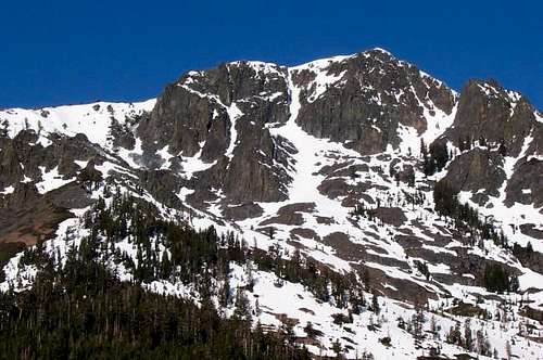
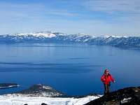
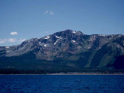
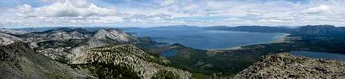
Mount Tallac is probably the most recognizable of the Tahoe Area peaks. With its distinctive "cross" of snow rising directly above the southwest corner of Lake Tahoe, Mount Tallac commands attention. While neither the highest peak in the area nor the hardest to summit, Mount Tallac nonetheless serves up enough adventure to satisfy nearly everyone. Compared to the giants of the southern Sierra Nevada, Mount Tallac is a mere child, standing at only 9735 feet above sea level. Still, it stands over 3,500 feet above the surface of Lake Tahoe, and from the summit, one may take in panoramic views of that amazing lake, as well as the enchanting peaks of Desolation Wilderness area. (Click here to see a 270 degree panorama from the summit). The views from the summit, as well as the mountain's proximity to highway 89 and its wide selection of terrain types, make Mount Tallac one of the top hiking and backcountry skiing destinations in California.
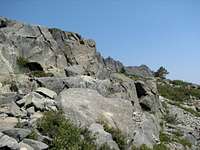
Geologically, Mount Tallac is situated roughly on the boundary between the granites of the Sierra Nevada batholith, and the earlier metamorphosed sedimentary rocks. The southern and eastern slopes, especially Cathedral Peak, are crumbly, clinky "metaseds", while the other parts of the mountain are a bit more solid, but not Sierran granite, quite like Mount Ritter.
Overview of Principal Climbing Routes on Mount Tallac
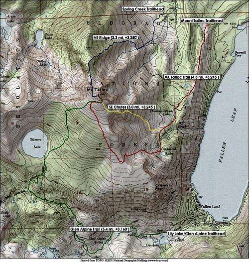
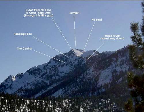
1) Northeast Ridge - This is the most direct (and thus the steepest) route to the summit. However, this route is really only feasible in winter, when the snow blankets the insanely thick and prickly bushes that grow like wildfire on the lower half of this route. Not surprisingly, the NE Ridge is the most popular route with skiers, snowboarders and snowshoers during prime season. It provides quick access to the summit, it usually contains a "boot pack" step trail, and it parallels the popular northeast bowl ski descent.
2) Glen Alpine Trail - A long (5.4 mile) route up the south side of Tallac, starting at the popular Lily Lake trailhead. Great views into Desolation Wilderness and of Gilmore Lake.
3) Mount Tallac (Cathedral Lake) Trail - In some circles, this is the "official" summer trail up Mount Tallac. Shorter (4.99 miles) than the Glen Alpine Trail, with equally beautiful views of Fallen Leaf Lake and Lake Tahoe on the ascent.
4) Southeast Chutes - A more fun (IMHO) variation on the Mount Tallac Trail, this route follows the main trail for the first 1/3rd, then involves some easy class 2/3 scrambling up the chutes above Floating Island Lake to the summit ridge.

Getting To Mount Tallac
Airports
· San Francisco International Airport : is located in San Francisco and is about three and a half hours form Lake Tahoe. Not as convenient as Sacramento or Reno-Tahoe, but it would be a better option for international travelers. Other options in the Bay Area are Oakland International and San Jose International Airports.
· Sacramento International Airport : is located north west of Sacramento, and is the biggest airport within two hours drive of Lake Tahoe.
· Reno-Tahoe International Airport: is located in Reno and is the closest major airport to Mount Tallac and the whole Lake Tahoe Basin.
· Lake Tahoe Airport: is located in Tahoe Valley between Meyers and the city of South Lake Tahoe. It can actually be seen from the summit of Mount Tallac, but it is a small airport and probably more expensive to fly into.
Public Transportation: Greyhound buses from Reno, Sacramento, and San Francisco to either Truckee, California, or South Lake Tahoe, California. Local bus transit between South Lake Tahoe and Truckee. Amtrak trains from Reno/San Francisco/Sacramento to Truckee.
Private Vehicle: Follow the above airport links to get from major metropolitan areas to the vicinity of Camp Richardson, California, on State Highway 89 (detail map).
Mount Tallac Trailheads
There are three main trailheads with reasonable access to Mount Tallac:
1) Lily Lake trailhead is at the end of Fallen Leaf Lake Road, which has signs from 89, 1/2 mile north (toward Truckee) from Camp Richardson. You'll find a paved parking lot here. Access point for Glen Alpine Trail
2) Mount Tallac trailhead is located about 3/4 mile north on CA 89 from Camp Richardson, directly across the highway from Baldwin Beach. The turnoff is well-signed. If you are coming from the north, this is first right turn after Spring Creek Road (just after the "25 MPH" right hand curve). If you are coming from the south, it is a left turn about 3/4 mile past the Lake Tahoe Visitor Center. Once you are heading east on this paved road, follow the signs to "Mount Tallac Trailhead". This trailhead is used for the Mount Tallac Trail, and the Southeast Chutes variation
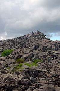
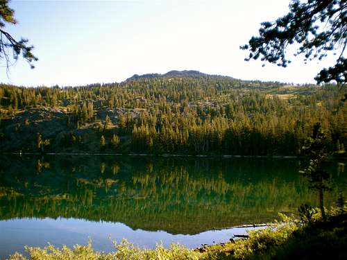 Tallac from Gilmore Lake
3) The Spring Creek trailhead, located in the subdivision NW of Fallen Leaf Lake, provides the shortest route to the summit. To get here, follow Highway 89 north from Camp Richardson towards Emerald Bay, then turn left (west) on Spring Creek Road. Coming from the north, the right-hand turnoff is just past the long Emerald Bay switchback. Coming from the south, it is the first left turn after the Baldwin Beach/Tallac Trailhead turnoff. Follow Spring Creek Road up into the neighborhood, always bearing left at the forks until you get to Wiyot Road, where you bear right and run into a dead end. Park here in one of the two turnouts, or park off the road back on Spring Creek. If you are coming on the weekend, get here early. If you're coming after 9 am on a powder day, fuhgeddaboudit... This trailhead accesses the Northeast ridge route.
Mount Tallac Camping & Red Tape
Probably because it is so close to population centers and easy to access from major highways, the Desolation Wilderness is one of the most heavily used wilderness areas in the country. To preserve its natural beauty, the Forest Service has restricted use to hikers, horses, llamas and the like. In Desolation Wilderness there are no buildings or roads. Bicycles and motorized vehicles are not permitted. Further, no wood fires are allowed -- you must use a camp stove. You must have a permit for either day-use or overnight camping in Desolation. There are fees for overnight camping year-round. From the Friday before Memorial Day to September 30th, a quota of 700 overnight users entering each day is in effect. Under the quota, each trailhead has its own allowance of overnight visitors who enter each day. It is wise to call ahead. Your permit is good at only the trailhead you reserve, only on the date of entry and only for the number of people specified. The maximum group size for a permit is 12, and stays are limited to 14 consecutive days. During the off-quota season there is no limit to the number of overnight users.
Day-use is currently not limited any time of year; however, the Forest Service may change this policy in the future if usage gets out of hand. Self-issue day use permits are available at most popular trailheads (but not the Spring Creek trailhead). This USFS page on fees outlines the complicated (and excessive, IMO) fee schedule for overnight permits in the Desolation Wilderness.
 Get an early start.
According the this USFS's page permits for overnight camping in Desolation Wilderness must be picked up at one of three locations:
1) Eldorado National Forest Information Center, located five miles east of Placerville on Highway 50. 3070 Camino Heights Drive, Camino, CA 95709 Phone: (530)644-6048 Open seven days a week, 8:00 a.m. to 5:00 p.m. with extended hours in the summer.
2) Lake Tahoe Visitor Center, located three miles north of the Highway 50/89 junction at South Lake Tahoe, on Highway 89. Open summer only. Call for hours, phone: (530)573-2674
3) Lake Tahoe Basin Management Unit, located two blocks north of the Highway 50/89 junction in South Lake Tahoe on Highway 89. Phone: (530)573-2694
Note: Self issue permits are not available at the Spring Creek trailhead. However, although I don't advocate lawlessness, not a single person I know has ever gotten a permit to do a backcountry ski tour on Mount Tallac. In theory, you could get a permit at the visitor center prior to heading up the trail, so act according to your own ethic and sense of law & order.
Mount Tallac Conditions
Caltrans Current Highway Conditions
Humboldt-Toiyabe National Forest Lake Tahoe Basin Management Unit El Dorado National Forest Updated Weather Information

When To Climb Mount Tallac
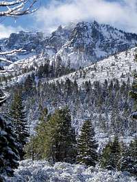
Mount Tallac can be climbed year round. I think the best time to climb and hike in the Lake Tahoe area is late July to late October. But late July (in normal years) most of the snow is melted out and Mosquitoes have cleared out for the most part.
During the summer months temperatures rarely get about 80° F or drop below 40° F at night. By November the weather changes dramatically with high temperatures around 47° F and lows about 22° F. Usually the heavy snows start in November. Highways 89 and 50 generally stay opened, only closed during strong snowstorms. But secondary roads that lead up to the trailheads close shortly after the snow starts.

Recommended Equipment for Mount Tallac
For a Summer Trip I Recommend the Follow Equipment
· Map & Compass
· Knife
· Matches/Lighter
· Sunglasses
· Sunscreen and Lip Balm
· First Aid Kit
· Food (extra food for emergencies)
· Headlamp and extra batteries
· Signaling Device (whistle and/or mirror)
· Gloves and Mittens
· Beanie, Sun Hat
· Wool or Synthetic Clothing
· Sleeping Bag - comfortable to 30F or 10F (in Winter)
For Winter I Recommend The Above Equipment Plus the Follow Equipment
· Down or Synthetic Parka
· Ice Axe
· Helmet
· Boots
· Gaiters
· Crampons
· Down Parka, Pants, and Mittens
· Double Boots or Over Boots
· Avalanche Beacon & Probe
· Snow Shovel
· Snowshoes or Skis
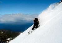
Backcountry Skiing
Readers of Couloir Magazine rate Tallac one of the "top 10" backcountry skiing destinations in the US (#9 to be exact). This is a justifiably popular skiing destination with a little something for everyone, so don't expect to have the mountain to yourself.
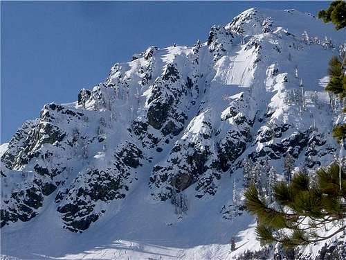
The most popular ski routes on Mt. Tallac are on the NE and SE faces of the mountain. The NE bowl is the trade route and sees probably 90% of the traffic on any given winter day. As a result, get there early on weekends and powder days if you want to get a parking space on Spring Creek and/or first tracks down the bowl. The SE ramp of Tallac provides good spring corn descents, while the east face routes -- including "the cross" couloir -- are for the extreme crowd. Finally, if long distance touring is your game, the Tallac-Dicks ridge is a great linkup with stuff in the central desolation wilderness. Below is an overview of some of the main bc skiing routes on Mt. Tallac:

1) NE Bowl This popular route is well described on Mpbro's page here. Expert skiers can find variations on the standard NE Bowl theme by turning off to the right at various points on the descent, leading to (i) the east face chutes; (ii) the cross "right arm"; or (iii) the so-called "front chutes". These are described in more detail on the east face ski descents page.
2) SE Ramp The SE ramp and its broad chutes are another good option for winter downhill fun. This route is better late season or after a warmer spell when the snow has consolidated and corned up a bit. Also, given the southerly exposure, this side tends to stablize more quickly after a dump. If you ski this side of the peak, you probably will still start your tour at the Spring Creek trailhead (at the bottom of the NE Bowl route). Thus, if you remember one thing, it is to be sure to traverse back towards your starting point before getting too low, or you will face a routefinding penalty and be forced to slog out of the Fallen Leaf Lake drainage.
3) East Face Routes The direct east face of Mount Tallac provides hair raising descents for the more accomplished skiers and riders. The most notable line is "the cross" couloir, which drops down the east face from a point just south of the summit. This line is tough to miss when standing atop the SE ramp, or from anywhere in South Lake Tahoe for that matter, as it is the most prominent feature on the mountain. Other descent options on the east side of the peak are the east face chutes and the front chutes. These are described in more detail on the east face ski descents page.
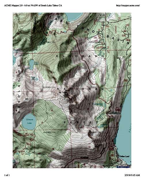 Mount Tallac Topo
Etymology
"Tallac, Mount [El Dorado]. The mountain is shown as Crystal Peak on the maps of the Whitney Survey, but the Wheeler Survey in 1877 applied the Indian name, which means simply "large mountain". According to Kirchkoff (p. 278) Tallac for for many years a famous resort after "Lucky" Baldwin built his hotel, The Tallac House, at the lake shore about 1875" Erwin G. Gudde, California Place Names "(c) A special category consists of placenames in which White explorers evidently interpreted Indian generic terms as if they were specific.
Thus in 1844, when John C. Fremont’s party first saw Lake Tahoe, they asked a Washo Indian what it was called, and the Indian said, dá’aw ‘a lake’; this was written down in English as “Tahoe.” In 1877, in the same area, the Wheeler surveying party asked another Washo to identify a California mountain, and the Indian said dalá’ak ‘a mountain’; this became Mount Tallac" William Bright, Native American Place Names Of The United States
Additional Mount Tallac Information
Maps
· USGS 7 ½-minute Emerald Bay
· Tahoe ski touring map - Has most of the prominent Tallac ski lines on it
· USFS Lake Tahoe Basin Management Unit Map
. Tom Harrison Maps: Desolation Wilderness Map
· Tom Harrison Maps: Lake Tahoe Recreation Map
Links
Useful Summitpost Links
· Lake Tahoe Basin
· Desolation Wilderness Area
· Sierra Peaks Section (SPS)
· Tahoe OGUL Peak List
· Sierra Nevada
· California Wilderness Areas
External Links
· Keep Tahoe Blue
· Lake Tahoe Average Temperatures
. www.truckeetahoe.net Detailed information on Tahoe-area lodging, weather, and transportation.
. Campground List Exhaustive, detailed list of RV and tent campground, public and private, in the Tahoe area.
. Mount Tallac Trip -- March 2002
. Yet another awesome time on Tallac
. 20 July, 2002 - a beautiful day for a beautiful hike!
. SP'er ahassid's glen alpine trail report
. Dicks/Tallac dayhike - May 12, 2000
Kudos
Kudos to Mpbro, who is the original maintainer of this page, and provided much of the background information for the Tallac page.
tarol - Jan 12, 2006 3:56 pm - Voted 10/10
Untitled CommentYour links are broken... Try these...
http://www.fs.fed.us/r5/ltbmu/recreation/wilderness/desowild/fees.shtml
http://www.fs.fed.us/r5/ltbmu/recreation/wilderness/desowild/permits.shtml
Katy Y - Jul 9, 2007 8:10 pm - Hasn't voted
distance correctionMy GPS registered 4.99 miles on the Mt. Tallac trail; see link for more information.
hgrapid - Jul 18, 2009 11:39 pm - Hasn't voted
Re: distance correctionI agree. The Mount Tallac Trail measured about the same as Katy's on the Mount Tallac Trail. We parked about 100 yards from the trailhead sign, and it was just about 5 miles to the top. I could be 4.9 to the top from the trail sign, but no shorter. It certainly isn't 4.3 miles. Also, the trailhead is at 6435 feet or so. Thus, it is 3300'+ to the summit.
JasonH - Jul 19, 2009 5:04 pm - Hasn't voted
Re: distance correctionChange made, thank you. Jason
evdk90 - Dec 10, 2018 8:45 pm - Voted 10/10
Winter Map AdditionYou might want to add the new Tahoe ski touring map (https://backcountryskimaps.com/product/tahoe-southwest/) to the maps section - it has most of the prominent Tallac ski lines on it.