

-
 17441 Hits
-
 89% Score
-
 28 Votes
|
|
Mountain/Rock |
|---|---|
|
|
46.59222°N / 8.24318°E |
|
|
Mountaineering |
|
|
10374 ft / 3162 m |
|
|
 Grosser Diamantstock from the southeast. The East Ridge is the right skyline.
 View up E Ridge
Overview
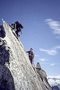 On E Ridge
Grosser Diamantstock, located a short distance north of Grimsel Pass, is the culmination of three ridges separating three valleys: Bächlital, Grübental and Hühnertal. It offers climbing on excellent granite at all levels of difficulty. Relatively speaking, these climbs are not overly long but require traversing a glacier to get to them.

Of the various routes, the East Ridge (Ostgrat) is the most popular. First climbed by Preiswerk, Zürcher, Anderegg and Baer in 1947, it offers spectacular ridge climbing at the UIAA III and IV (~5.4 to about 5.6) level. The direct start is UIAA V (~5.8).
The Bächlital, with its proximity to a main road and excellent trail is much visited by sport climbers and families. The SAC regularly offers youth climbing courses here, so it can be quite busy on a summer weekend.The Gruebental and the Hühnertal also offer a great variety of sport and alpine routes.
Getting There
Public transportationOne can take a train to Meiringen from either Bern via Interlaken or come from Luzern. From there take Grimsel Pass postal bus (Postbus). The bus stop for Grüebental is Hotel Handeck. For Bächlital the stop is at the Staumauer Räterichsboden (a hydrodam). In the off-season and during winter, the bus only goes as far as Guttannen, after which it is advised to hire an alpine taxi (Alpentaxi Guttannen, Werner Kehrli, 033 / 973 12 09).
If coming from the south, travel by train as far as Oberwald, Postauto from Oberwald to Gletsch - Grimselpass - Staumauer Räterichsboden or Hotel Handeck. In winter this route is not open.
Private Transport
The public transportation route is also the one to drive with your own vehicle. You can park at either Hotel Handeck or the dam, depending on which hut you are approaching. During winter or when there is snow on the road, you must buy permit to continue past Guttannen or take the taxi (see section above for taxi information),
Routes Overview
 Direct Start
East Ridge
East Ridge: This is the most popular route. 400m vertical of climbing. It starts from the Unteren Bächlilücke, which is reached from either hut. The direct start is UIAA V, ~5.8 but can be avoided. After that one follows the ridge , staying on the ridge crest as desired. In a few places one has to leave the ridge crest. Some pins and bolts are permanently placed. 2 to 3 hours from the lower gap.
Other Routes:From the Grüben hut: NW-ridge (PD), NE-face (S or SS)
Descent : One can traverse the entire mountain by descending the SW ridge (UIAA II, 4 - 5) to the Oberen Bächlilücke (upper Bächli gap). From the Oberen Bächlilücke one can descend to the Gaulihut , from where other climbs in the region are accessed.
The direct descent is through the south-east flank to a rappel point to the glacier. Both descent routes are also recommended ascent routes. The bergschrund at the base of the SE flank in late season can be quite large.
Sport Climbing:There are rock plates and cliffs near both huts that offer a great variety of sport and pleasure climbing (plaisir) without having to cross a glacier. The Bächlihut touts itself as being family friendly and sponsors youth climbing camps, etc.
Accommodations
ValleyIn the valley between Meiringen and Grimsel Pass are a variety of small villages with hotels, youth hostels and camping areas. This is a popular vacation site and can be crowded.
Huts
Grueben hut (2512m) : From Hotel Handeck (1401m) on the marked trail to Ärlen (Ärlenalp with a spring) and further via Egg (cairn) to the beginning of Grübensee (reservoir). From there over a creek and along the south shore of the reservoir to the delta of the Grueben glacier (marked with cairns). Continue along the northern lateral morraine of the glacier to the final slope up to the SW side of the hut. A large cairn marks the final trail up to the hut. About 3 hours. This hut has no warden. It provides blankets, pillows and a cooking niche. There is no telephone.
Bächlital hut (2328m): Over the dam Räterichsboden in westerly direction on stone stairs to point 2157. Continue in the same direction up the valley to the hut. The trail is on a rock terrace about 150 m above the valley bottom. About 2 1/2 hours. In high season the hut is very busy and making reservations is advised.