
-
 9072 Hits
-
 84.27% Score
-
 18 Votes
|
|
Mountain/Rock |
|---|---|
|
|
42.85450°N / 0.7276°W |
|
|
7181 ft / 2189 m |
|
|
Overview
 Chipeta
 Chipeta
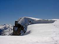 summit
Located in Ansó's valley, the first valley of the Pyrenees of Huesca from the west, the Chipeta is as steep prow of ship over the Selva de Oza (Oza's forest) being an exceptional balcony to observe the valley of Echo and its mountains as the colossus Bisaurin or the nice Castillo de Acher, for what it is one of the mountains most visited of the zone owed also to the facility of the routes of ascension.
Its modest height in comparison with the summits that surround it does that it is less acquaintance than other big mountains of the zone of Belagua/Ansó as Anie (2507m), Mesa de los Tres Reyes (2444m), Petrechema (2377m), or Acherito (2362m).
Generally can be promoted by both sides for many routes, though the 3 principal routes are:
-Zuriza/Taxeras-Col de Petraficha (SD, 2h 30min, slope 940m)
-Selva de Oza-Col de Estriviella(SD, 2h15min, slope 950m)
-La Mina-Col de Petraficha (SD, 2h 25 min, slope 960m).
Normally it is a good option to design a slightly longer tour including other such nearby summits as, in the south side, Chipeta Bajo (1897m), Pico Tortiellas (1909m), Puntas de Tortiellas (2079m) or Estriviella (2048m) and, in the north side, Petraficha (2185m), Quimboa Alto (2196m), Quimboa Bajo (2180m) or Anzotiello (2202m).
You can see a general map of the zone here.
 |  |  |  |
Getting There
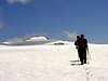
 Chipeta from Oza
For the approach to Zuriza and Tacheras, we'll have to get there from Pamplona or Huesca. Follow the road linking both of them (N-240) until the crossing of Venta Carrica near dam of Yesa. The signal indicated "Isaba/Roncal/Belagua". Follow this road (NA-137) until we arrive to Isaba. After Isaba keep going north (NA-1370) for 3 more kilometers and turn right on the crossing marked as (Zuriza /Ansó). This small road (NA-2000) will take you across the valley of Belabarce and to the camping area at Zuriza, under the Sierra de los Alanos. In the croosroad turn left for the camping area and follow the dirt road leading eastwards and signposted "Barranco de Tacheras" in the right side (the left side is for mountain hut of Linza). Leave the car at the point where this dirt road crosses the river.
For approach to Selva de Oza see the page of Castillo de Acher
For approach to La Mina follow the track from selva de Oza for 7 km to the north.
Red Tape

No permits required. No parking pass, but generally in summer you must arrive soon in the morning to place the car because the zone had a lot of people.
When To Climb
All the year.Easy climb in summer (june to september).
Harder in winter but not complicated with crampons and ice-axe in the route from Zuriza/Taxeras. The east routes (Col of Petraficha and Col of Estriviella) are inclined to little avalanchs of snow, specially at the begin of spring.
 |  |
Camping
See the pages:*Mesa de los tres Reyes
*Petrechema.
*Castillo de Acher
Mountain Conditions
Meteo-FranceNational Institute of Metereology of Spain, see province of Huesca in NW side.
External Links
- Chipeta ski
Chipeta is a good mountain for ski in winter. Page with route and pictures (spanish).