
|
|
Mountain/Rock |
|---|---|
|
|
37.84620°N / 118.3513°W |
|
|
Hiking |
|
|
Spring, Summer, Fall, Winter |
|
|
13140 ft / 4005 m |
|
|
Overview
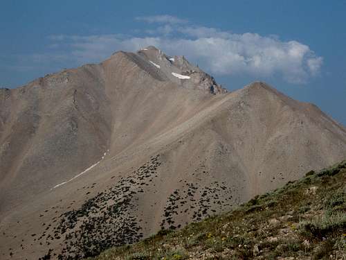
The summit of Boundary Peak is the highest point in the State of Nevada. Residing at the Northern end of the White Mountains, it is part of a twin peak with Montgomery Peak in California, which is 298' higher and separated by 2/3rds of a mile via a very rocky ridge. Boundary Peak itself only has a prominence of a little over 250'.
Boundary Peak derives its name from the proximity to the boundary between the two states that runs down the saddle between the two peaks and was likely named by surveyors who were working in the West in the mid 1800s. The actual boundary between the two states was finally legally settled in 1980. The controversy stemmed from a survey done in 1873 by Alexey VonSchmidt. His survey placed placed the border from Lake Tahoe to the Colorado River askew with that established by the U.S. Coast and Geodetic Survey between 1893 and 1899, putting Boundary Peak in California. If the USGS had not changed the border, Wheeler Peak in Great Basin National Park, would be Nevada's high point. Many still consider Wheeler Peak a more spectacular peak and would have been a more worthy destination for the highest point in the Silver State.
Most people who climb this peak are doing so in their quest to gain the high point in as many states as possible. There are two routes that meet up at a saddle 2,300' below the summit. Trails lead to the saddle, while the remaining stretch is a strenuous walk up through a tremendous amount of scree with some minor scrambling near the summit.
 |
 |
 |
 |
 |
Getting There
No matter what direction one is coming from, you must get to Nevada Highway 264. About 200 yards south of the junction of Nevada Highway 264 and Nevada Highway 773 is a rough dirt road heading west. A 4-wheel drive is not required, but a high clearance vehicle is recommended, especially for the last mile or so. There are also a couple of small streams/washes to be crossed. Follow this road for approximately 14.7 miles to the trail head. At 2 miles continue straight at a cross road and again at 2.4 miles. At about 11 miles you will come upon the B & B Mine, here you will turn right and the quickly left. Going straight instead of the right will take you to a parking area, two rights take you to the mines buildings. At mile 12.1 there is another road junction but plainly signed. Proceed up the canyon which is a right hand turn. At about 13 miles you will pass a small reservoir and possibly some fishermen. Here the road narrows and gets quite rough.
Some people do use the Queen Canyon Road off U.S. Highway 6 just east of the California - Nevada border. It is a very rough road but passable to the Queen Mine at 9200 feet.
 |
 |
Red Tape
There are no wilderness permits required for passage into or camping in the Boundary Peak Wilderness. There is a sign-in / sign-out log in a wood box on a post at the trailhead. If you plan on camping, a campfire permit is required. This can be aquired via:
Inyo National Forest
White Mountain Ranger District
798 N. Main St.
Bishop, CA 95314
(760) 873 - 2500
When To Climb
The usual climbing season is June through October once the snow is gone. It can be a nice snow climb (some say a better and easier one) earlier in the year.
 |
 |
 |
Camping
Some people camp at the small reservoir along the road. Some have camped at the trail head. One can also camp up in Trail Canyon, but there are very few level places to place a tent.. Be sure to bring plenty of water as this is a desert. The only water is a small stream with a spring up Trail Canyon but there are also alot of cows grazing, drinking the water and doing their thing in it, so be sure to treat any water from this spring / stream.
Mountain Conditions
For current conditions call the White Mountain Ranger District Office at (760) 873 - 2500
Ancient Bristlecone Pines
There is a nice bristlecone pine forest on the northslopes of the East Ridge of Boundary Peak maybe a mile southwest of the trailhead. Coming back via the East Ridge allows one to descend through this forest on the way back to the car.
 |
 |
External Links
- Information about hiking to Boundary Peak
Fast facts and a complete route description of the hike to Boundary and Montgomery Peaks. - Photos of my trip almost to Boundary Peak
My 6/25/05 hike was cut short by a lightning storm just before I reached the summit. - Boundary Peak - Queen Canyon Mine route
mcintoshjr - Jul 4, 2005 11:54 am - Hasn't voted
Untitled CommentThe description of the access to trail canyon is accurate.
We took the East Ridge route, when taking this route you will need to do some side-hilling to avoid giving back altitude, so resist the urge to run the ridge. There was some snow above the false summit and reports from a day earlier said that post holing was a problem, we found good snow well past noon but it was well below freezing at the camp the night before.
Believe it or not there was NO WIND on the summit, a glorious day.
Descended the standard route, the scree had allot of medium sized boulders which precluded making good time.
DO NOT expect any services within 50 miles of this peak.
Deb - Sep 3, 2012 7:58 pm - Hasn't voted
Re: Untitled CommentI had service at Queen Mine camp area. :)
Running Swimmer - Dec 8, 2005 7:43 pm - Hasn't voted
Untitled Commentwe found that if as soon as you enter the brush you bush wack your way to the ridge directly to you left, and follow that ridge to the top. we took this way up, and the trail canyon down, and decided this hike was much easier.
barneyzang - Oct 12, 2006 11:55 pm - Hasn't voted
Google Earth track logA Google Earth track log can be found here. Contains track for turnoff from highway six up to the Queen Canyon Mine trailhead + summit tracks.
keema - Oct 13, 2006 3:05 am - Hasn't voted
Re: Google Earth track logyour link provided a page of gobbildy gook.
barneyzang - Oct 14, 2006 11:11 pm - Hasn't voted
Re: Google Earth track logIf you save the link as a file (should be called BoundaryPeak.10.2006.kmz) you should be able to open it in Google Earth.
Alpinist - Aug 29, 2007 3:27 pm - Voted 10/10
Queen Mine RoadNote: There is another water tank on the left and dirt road on the right 6 miles from Benton. We drove in at night and upon seeing the tank just opposite of this road, we mistakenly turned off Hwy 6 too soon. There is a wire gate that does not state to Keep Out, as you might expect on a private road. Do not be confused by this road. Mark your odometer and be sure to take the correct road 9 miles from Benton, as stated in the route description. We took the wrong road for about 2 miles and were miffed at how rough it was. Queen Canyon Mine Road is quite gentle comparatively speaking.
Alpinist - Aug 29, 2007 3:29 pm - Voted 10/10
Queen Canyon MineIn case anyone is wondering, they used to mine flourite at the Queen Canyon Mine. Source.
Moogie737 - Nov 4, 2007 3:13 pm - Hasn't voted
Official Trail Head sign for Queen Canyon Mine routeAs of 11/3/07 the trail head sign is totally blank; there is no writing whatsoever on it. Also, although the trail splits almost immediately after passing this sign, the best way is a sharp turn to the right. If you continue on the left hand trail you work your way into a narrow canyon and find that the trail more or less peters out. But, you might see some wild horses in that canyon. :)
gbrill - Aug 5, 2008 8:26 pm - Voted 7/10
Assending and DescendingClimbed Boundary Peak in about a half day on August 3, 2008. Only ran into one other person who summited and a few others who got lost and were looking for the trail up. For anyone reading this who hasn't done this peak, when you make your way up the gulch you want to aim at the low saddle on the right. Myself and the other climbers that day spent a good portion of the way back trying to find the correct trail for the ascent but had little luck. Basically when you get out of the hedges and your about to enter the sage brush (I built a rock pile at this location), turn right and follow the creek bed to the saddle. When you get close the saddle there will be a faint trail on the left hand slope, marked by little pieces of ribbons. Take the left slope and traverse to the saddle (you will find the left slope has much firmer ground than the right). Once you reach the saddle your golden, there is a pretty obvious trail that heads off to the left and follows the ridge line to the summit. On the way back you can shortcut the descent by taking the saddle over the drainage that flows into the sage brush field (a word of caution, this can be a little hard on the ankles since the slope is so loose). Hope this helps.
Moogie737 - Jun 29, 2010 3:31 pm - Hasn't voted
Road between Queen Canyon mine TH and the "real" THAs of 6-25-10 the road up to the "real" TH is much improved over what it was before. However, one should probably scout it out on foot to assess your chances of driving without ripping your tires to shreds on sharp rocks before just driving up. Such a scouting trip on foot would only take 25 minutes or so.
Bark Eater - Jul 23, 2010 8:16 am - Hasn't voted
2010 updates1. Road to Queen Canyon Mine is in good shape for pickup - SUV but may be a challenge with a passenger car. 2. Our party estimated the RT distance from the mine to the summit as between 11-12 miles. 3. Queen Mine route is VERY easy to follow - well worn path until above 12K feet. Then requires a bit of route-finding. 4. Look for the herd of wild horses on the long flat ridge between the two saddles. Great mountain!
Jesus Malverde - Aug 25, 2012 10:23 pm - Hasn't voted
Boundary Peak Area Activity OptionsThe ascent of Boundary Peak not enough to feed your rat? Consider doing a bicycle circumnavigation of the White Mountains (pre or apres climb) with the White Mountain Double Century: http://www.ndzone.com/White_Mountain_1.html Also, a soak or overnight camp at nearby Benton Hot Springs might just hit the spot: http://www.historicbentonhotsprings.com/
KathyW - Sep 3, 2012 9:08 pm - Voted 10/10
Road Conditions - Queen Mine RoadDrove the road on 9/2/12. The road from Hwy 6 to the Queen Mine has deteriorated a little over the last few years and would be more difficult with a low-clearance passenger car, but could be done with very careful and slow driving (someone made it in a fairly low clearance vehicle while I was out there but I wouldn't have wanted to be driving that vehicle). The road from Queen Mine to Kennedy Saddle (Also known as Queen Mine Saddle) is in better shape than it was a few years ago when I last drove it and easy to drive in a stock Toyota Tacoma with 4WD. It might be do-able with high-clearance 2WD except that one tight turn might create a bit of a problem trying to get going again or backing up to negotiate the turn. So, if you have a truck with 4WD keep on driving up to the saddle and save yourself the extra walking.
brichardsson - Aug 13, 2013 4:07 pm - Hasn't voted
road conditions to queen minedrove the road on 8/10/13. the lower end (the part to queen mine) is in pretty good shape; in fact, someone in our party made it to the mine in a toyota camry! the road beyond that was very loose scree, and a two wheel drive high clearance toyota truck could not maintain traction on the road and eventually had to go back down.
Bruce Christensen - Aug 31, 2013 12:57 am - Hasn't voted
Re: road conditions to queen mineWe drove (well, tried to drive) the road from US 6 to Queen Mine on 23 Aug 2013 in a Hyundai Elantra passenger car. We made it a good part of the way up, but it was a pretty rough drive, and we didn't make it all the way to to mine. We scraped the underside of the car pretty well in a few places, too. I guess I'm just saying that even though someone made it in a Camry, that doesn't mean that you should count on making it to the mine in a passenger car.
oldslab - Oct 31, 2013 9:24 pm - Hasn't voted
Queen Mine RoadWe drove our 1995 Plymouth Voyager soccer mom van to the saddle and spent the night there before doing boundary the next day. Really cool! Yes, the road sucks and you have to give it some gas especially in one steep place before the sharp turn. Coming down was kinda sporty too making that sharp left turn and going not to ride he scree to the valley. If anyone has a pickup or 4wd they should be able to make it to the mine at least. There was a small import of some kind that a girl and guy drove up with really low clearance. Have fun!
GainAlt - Dec 24, 2013 11:12 am - Hasn't voted
Queen Mine Road is passableQueen mine road is passable to the mine at about 9400' as of 12/14/2013 via highway 6. I was in a Ford Explorer and had no problems getting to the mine. Attempted to get to the saddle but there was too much snow to drive safely. Hike was awesome, started at 230am with a full moon, light wind and about 10 degrees. Trail had about 5-6 inches of snow. Don't be fooled, the hike only gets harder as you keep going. The last 0.5 mile is nothing but large boulders covered in black ice, very tricky. It was very difficult to get around them and find the route to the summit. Scree was not bad at all, I am thinking probably because it was frozen in place. Had a great time and would rate the hike as intermediate. Make sure you have good solid boots and hiking poles.
becky - Jul 7, 2014 3:05 pm - Hasn't voted
queen canyon routea little wash out down low, but small vehicles made it with ease. the upper section of the road is fine, just a little steep. good tires and 4x4 is recommended. gets you up high for a fabulous hike to the peaks!
TBerger - Oct 3, 2014 7:27 pm - Hasn't voted
Queen Cyn UpdateIn late September 2014 the road to Kennedy Point pass was passable by 2-WD, high clearance vehicle. I drove a rental Jeep Patriot. From the highway to the pass (9,757') takes about 45 minutes.