
|
|
Mountain/Rock |
|---|---|
|
|
36.40430°N / 50.96500°E |
|
|
14780 ft / 4505 m |
|
|
Overview
NOTES:Click for Introduction to Central Alborz Mountains.
Click to see the Map of the Takhte Soleyman Massif.
Click for an aerial photo of Takhte Soleyman Massif.
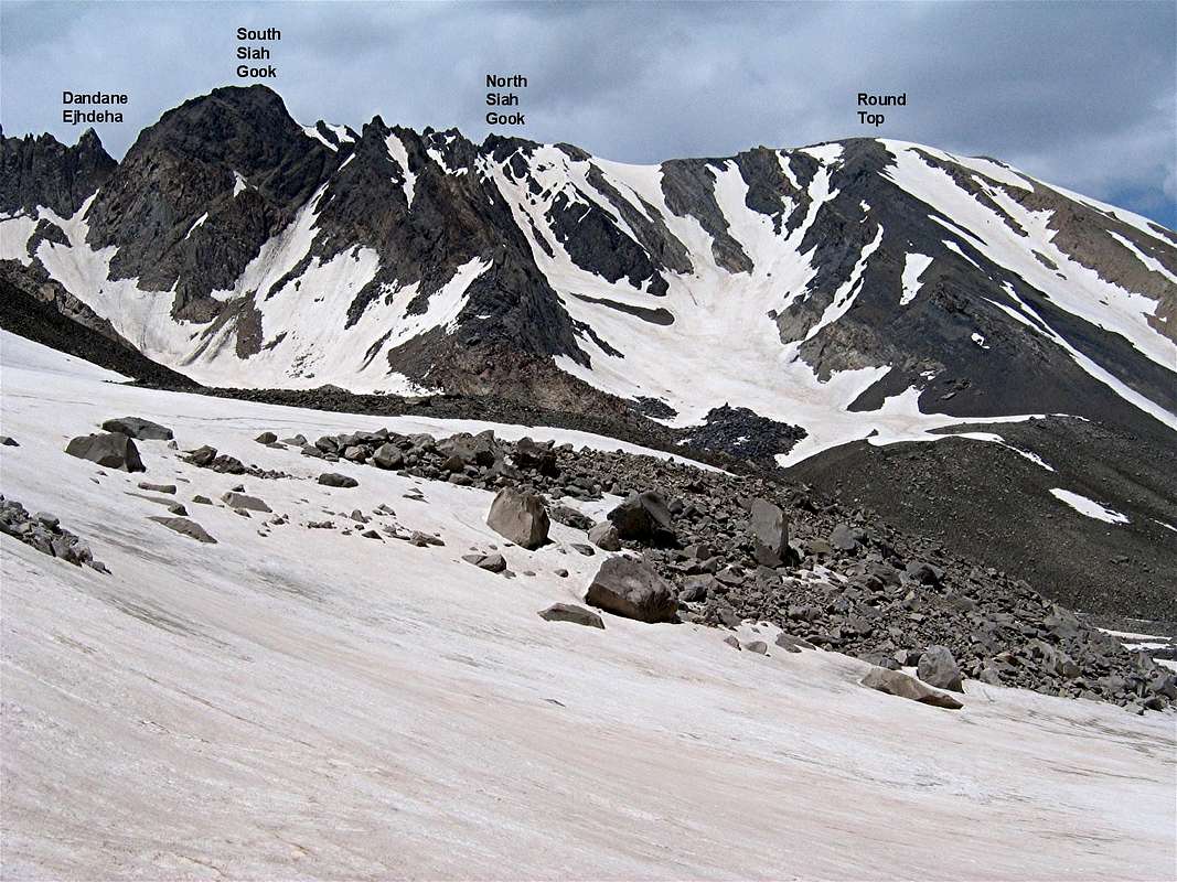

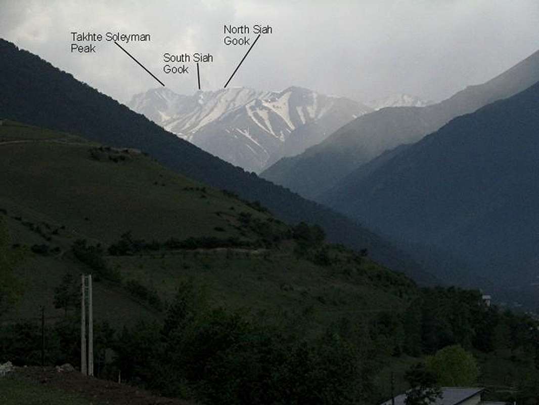
In the central portion of the Takhte Soleyman Massif, between the Takhte Soleyman and Rostam Nisht Peaks you will find a jagged 1.5 Km long ridgeline that gives rise to many rocky high points. Detailed topographic information about this ridgeline is non existent. All of the topographic maps that I have ever seen depict the ridgeline as having a smooth top and give no information about the many ups and downs on the crest of this ridgeline. Three of the most prominent high points on the ridgeline have nevertheless been given names and other sources have provided approximate elevations for them. North to south, these three points are as follows (the elevations of the first two points are per my GPS measurements):
1) North Siah Gook Peak 4505 m
2) South Siah Gook Peak 4510 m
3) Dandane Ejhdeha (Dragon’s Tooth) approx 4400 m
North Siah Gook Peak is the northern-most of the jagged high points. To the south, North Siah Gook is connected to a series of crags that lead to a huge rocky block that is known as South Siah Gook Peak. The north face of North Siah Gook has very gentle slopes that go down to reach a 4446 m round-top high point.
The western slopes of North Siah Gook are quite steep and drop into the valley of the stream that drains the Haft Khan Glacier. The eastern slopes of North Siah Gook are wall-like and reach the tail end of the valley of Alam Chal Glacier where the Sarcahl Shelter (3750 m) is located. This shelter is often used by those who go to climb the highest peak of the massif: the 4850 m Alam Kooh Peak. It can also provide access to the easy northern slopes of North Siah Gook Peak.
 |  |  |  |  |
Getting There
See Map.
From downtown Tehran drive 40 km west to the town of Karaj and take the Karaj-Chalus Road north (This road crosses the Alborz Mountains taking you through the Kandovan Tunnel to the Caspian Coast). 30 km south of Chalus, you will reach the town of Marzan Abad. Turn left and follow a side road into the Sardab Rood River drainage and to the town of Roodbarak. Distance from Tehran to Roodbarak is roughly 200 km (125 miles)
 |  |  |  |
Red Tape
I am not aware of any permit or fee requirement. Hunting will require a license. |  |  |
When To Climb
June to October is the ideal season. Climbing in winter will obviously be much harder due to extreme cold and heavy snow cover.Camping
Accommodations are available at the Iran Mountaineering Federation Hotel in Roodbarak (call Mountaineering Federation at 98 21 8839928) or camp anywhere.Mountain Conditions
In summer, the weather is generally clear. Unexpected thunderstorms do occur frequently. Precipitation at higher elevations will almost always be in the form of snow/hailMiscellaneous Info
TOURS/GUIDES:If you are not familiar with these mountains, you will greatly benefit from the presence of a guide. I worked with Araz Adventure Tours and was very satisfied with their services. They were flexible, courteous and knowledgeable and were able to custom design an 8 day trekking tour allowing me to climb the lesser known peaks of the area. My guide: Mr. Rasool Naghavi was a kind man who was a native of Roodbarak and knew the mountains like the back of his hand. Having climbed Everest and several other Himalayan giants made him, in my opinion, one of the most qualified guides for these mountains.
MAPS:
1) The most accurate topographical maps of the area are those with a scale of 1:50 000 (contour lines of 20 m) provided by the Iranian Armed Forces. You will need sheet #6162 I "Shahrestanak" for Alam Kooh and North Siah Gook(To fully cover the entire Takhte Soleyman Massif, you will also need sheet #6262 IV "Rudbarak"). These maps are available in Tehran at the Geographical Office of the Armed Forces on Moalem St. (98 21 8408088) for the equivalent of $3 per sheet (in 2004). Outside of Iran, the same maps can be purchased at www.cartographic.com for the exorbitant price of $150 per sheet (in 2003). These maps are in Farsi. While they give the exact elevation of most of the peaks, they do not give the names of the individual peaks.
2) Soviet Military Maps sheet # J-39-126-G available at www.omnimap.com. I do not recommend this map. It seems as if the creators of this map lacked detailed info and eliminated many of the lower peaks.
3) Different schematic maps available in Iran. My favorite is the "Guide Map of Takht-e-Soleiman & Alam Kuh Region" by Iran Kuhro Co. available at Varzesh Kooh store, Ferdowsi Sq., Tehran (98 21 8826642).