
|
|
Mountain/Rock |
|---|---|
|
|
48.56930°N / 121.1021°W |
|
|
8334 ft / 2540 m |
|
|
Overview
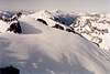
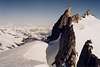
I was a little austere shortly after failing to tag this peak back in April. I had come to within 20 vertical feet of the summit but was turned back due to icy conditions, lack of technical gear, and feet plastered with plastic ski boots. The final "problem" was too much for me (for us). I was thus adamant about coming back sometime this summer to scratch it off my Top 100 list (approx. 90/100). And come back I did on a solo excursion.Austera Peak is the centerpoint and highpoint of a long, sharp ridge called Austera Towers located roughly halfway between Primus Peak on the north and Klawatti Peak on the south. The peak is rough, eroded, and precipitous and more or less blends in with the many serrate ridgelines that disconnect the heavily glaciated drainages. All these peaks, ridgelines, and glaciers provide Austera with what I consider the quintessential Washington alpine scene (see photos at bottom of this page). The view south toward Eldorado Peak is simply outstanding and you may find you've wet your pants in slack-jawed austeria.
Rock is Eldorado Orthogneiss. First Ascent was on Sept. 16, 1965 by the quintet of Joe & Joan Firey, John & Irene Meulemans, and Anthony Hovey. Winter ski ascents have been done.
 |  |  |
Getting There
[Copied from Klawatti Peak page]There is only really one approach to this peak and that is up from the Cascade River past Eldorado Peak. Any other approaches are up to you and your sense of adventure. Surely they will be much longer. This can be anywhere from a one-day outing to a multi-day outing depending on your objectives. Certainly, if you're going to be in the area you might as well stay an extra day to enjoy the other peaks there (Tricouni, Primus, and Klawatti peaks, also Eldorado Peak, Dorado Needle, and innumerable technical crags).
There is also really only one route up this peak (see below).
Approach to Eldorado Ice Cap
[Copied from Klawatti Peak page]This is the same as the standard approach to Eldorado Peak. From Marblemount on the North Cascades Highway (SR-20), drive 19 miles east on the Cascade River Road. A parking lot on the right with a toilet is your trailhead (~2,150 ft). The first order of business is getting across the river to its north side. There used to be a big log a few hundred yards downstream of the parking lot but it has since been washed away (probably by the rainstorm of 10/20/03). Our early April 2004 trip to Primus used a crossing about 100 yards downstream of the parking lot. This crossing used three logs and three gravel bars. I'm not going to present detailed info for the crossing as it seems to change all the time. Suffice it to say, once you get across, the second order of business is to locate the climber's trail on the other side. This is not an official trail, hence the park service doesn't maintain it at all, which is too bad (they should given the amount of traffic it sees). The trail is maybe 140 feet into the forest on the other side. It sort of parallels the river for a stretch (40 yards maybe) before turning uphill. The trail is west of Eldorado Creek but not too far west. It seems a lot of people can't find the trail on the other side of the river and crash brush upwards too far west of the creek. The best thing to do is take the extra time to locate the trail down in the flat before commencing uphill. The trail is actually quite good considering it's not maintained. However, it is steep and rooted (and windfallen--especially down low), so care must be taken.
For 1,800 feet, the trail steadily climbs up through verdant forest and ends at ~4,000 ft on the left side of "the boulderfield from Hades." In early season (on or before April), this boulderfield is snowcovered. Backcountry skiers can float right over the top of them. However, as melting goes on, more and more boulders and their associated interstitial pocket pitfalls lurk to ensnare the unwary skier. Not that it would be any easier for those booting it through. If the snow is unconsolidated or if it is warm, this can be hell on earth.
The boulderfield relents eventually. In summer, a trail forms on its eastern fringe (but still west of the creek). The trail turns into a path and finally opens up to the alpine terrain of Eldorado Basin at 5,600 ft. A lot of parties elect to camp in this basin. Others continue on for a camp closer to Eldorado Peak. This requires one to climb left over a rib into the next basin west (Roush Basin). I have always thought the geographical naming strange in that Eldorado creek and basin don't actually drain Eldorado Glacier, where as Roush Basin (and Roush Creek) is the one that drains the glacier. Seems like the names are backward. Anyway, there is a flat section on the rib at ~6,100 feet that allows access to Roush Basin. The west side of this rib can be tricky in summer--especially for beginners. Slabby rock and heather with some exposure if you fall make for an interesting downward traverse for a few hundred feet. In winter this is all snowcovered and much easier (ice axe might be handy--especially if icy/hard snow in the wee morning hours). Once into Roush Basin, simply climb up the eastern fringe of the Eldorado Glacier for about 1,300 ft to the large snow and ice dome (c. 7,500 ft) immediately SSE of Eldorado Peak. Gawk at the beauty before and behind you. Klawatti Peak will be visible across the way to the NNE. To its left through the gap (Klawatti Col) is where you'll be going. At this point you're still a good 3.5 miles away from Austera.
Route from Ice Cap to Austera Ridge
To get to Austera, cross north from the snow and ice dome to the small notch/saddle at ~7,500 ft on the lower East Ridge of Eldorado. Continue beyond this for 1.5 miles to Klawatti Col (7,800 ft) on the Klawatti Peak's west side. Depending on season, crevasse routefinding will be more or less of an issue. There are a few ways up to the top from the col. On August 20, 2004, I was able to traverse at approximately the 7,600-ft contour, avoiding crevasses as necessary. The exact route will obviously change from year to year.From Klawatti Col, traverse 0.4 miles on the upper reaches of a lobe of the McAllister Glacier below the West Face of Klawatti Peak to the 7,900 ft Klawatti-Austera Col. In winter/spring it should be pretty easier to get over this col (there is a short rock wall; might be a snow bank at your pleasure). On the east side of this col is the Klawatti Glacier. Directly to your north is your objective peak beyond a turret tower on its South Ridge. In summer/fall (particularly in late season), receding snow embankments and moat issues at Klawatti-Austera Col will make the crossing more difficult ranging from Class 5 downclimbing at the lowest notch to Class 4 to the right (SE) of the lowest notch. The latter can be reached by a snow bank then a step across to rock. The col crossing can be done unroped if you're careful about it.
Once across the col, bear northward closely right of the turret. The first few hundred yards is flat before the glacier begins climbing up to the Austera's summit ridge. Eventually, the snow ends. You can climb onto the exposed rocks either to the right (at the beginning of Austera's East Ridge) or to the left (beginning of the South Ridge). I recommend the latter as it will give you a view of the summit tower. Plus, you'll get an early view of the super-duper McAllister Cirque.
 |  |  |
Final Route to Summit
Mount the rocky ridge and take it leftward (NW) over Class 3 rock to the final notch. In winter/spring, steep snow may make getting into this notch hazardous. There are then three options to continue:Option 1 -- Try to climb the chockstone gully on the left. Be prepared for a 15-ft Class 5 climb involving stemming and face climbing on the left wall. The chockstone will come into play for a move or two. It looks like it's ready to come out and flatten you but it is actually quite solid. I started the option but backed off not knowing the solidness of the chockstone. I gauged it 5.6-5.8. In winter/spring snow may choke the gully thus alleviating some of the rock climbing difficulty. However, the snow will be steep and icy. Crampons may be necessary, which will no doubt require some dry tooling moves.
Option 2 -- Just to the right of the chockstone gully is a feasible break in the rock wall. I climbed halfway up this (Class 4) but the rock was trending toward being overhung and looser Class 5. I again backed off. From above I would later see the features above the slight overhang were downsloping (i.e., not positive holds).
Option 3 -- This is the best/easiest option. From the notch before the summit tower, go right on a narrow Class-3 ledge for 30 feet around a corner then climb directly upward (left) on Class 3/4 with good holds. Climb up to the top of the horn right of the chockstone gully then downclimb 10 feet of Class 4 to the notch above the chockstone.
The last 30 feet of climbing from the chockstone notch is the most interesting. It starts out Class 5, decreases to Class 4, then finishes as a short Class 3 scramble to the top. I would rate the Class 5 bit as a 5.7 face traverse on crimp holds and small ledges for two moves. Fortunately, the exposure for these moves is not that great (there is a gully about five feet below your feet).
 |  |  |  |
Red Tape
Austera Peak lies within North Cascades National Park, so park rules apply. Best to consult with the park service for specifics (they'll probably try and put a blue bag in your hands). A camping permit will need to be acquired though you could probably forego this for the north side approach (it is unlikely you'll see anyone). The south side approach can be crowded since it is the standard for climbs of Eldorado Peak. The party size limit is 12 persons (dogs don't count as persons). Permits for this approach can be hard to come by (I guess). In early season when the Marblemount Ranger Station is closed, the permits are self-issue outside the building. Permits can also be obtained in Newhalem (I think).When To Climb
The good thing is you can practically climb this peak all year though the technicalities will be different. In winter/spring, a ski tour can be made to the peak, your main concern then being your ability to climb the final summit tower with ski boots on (you could take other shoes in your pack for this). Crevasses will be covered with snow bridges. In summer/fall, the crevasses will be more open therefore their dangers visible. However, the later in the season, the more ice as opposed to neve that is exposed. |  | 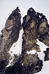 |  |
Camping
For the approach, good camping can be found in Eldorado Basin (~6,000 ft), Roush Basin (6,300 ft), the Eldorado snow and ice dome (7,500 ft), the East Ridge of Eldorado (7,500 ft), or Klawatti Col (7,800 ft). There is not much point in camping farther out than Klawatti Col (unless, perhaps, if you will be going out a different way--like for a traverse down into Thunder Creek).The climb can be done in a long day if you're in good shape (I did the climb round-trip from the car in 12.5 hours). If you think you are fit enough and will only be climbing Austera, then I recommend attempting this as a one-day climb.
Mountain Conditions
You can go here for a report on conditions in the area. Also, this page will be useful.Localized Forecast
Marblemount Weather Forecast (nearest town).
 |
The Quintessential Cascade View, Part I
 |  | 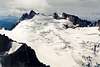 |  |
The Quintessential Cascade View, Part II
 |  |  |