
|
|
Mountain/Rock |
|---|---|
|
|
36.40920°N / 50.96000°E |
|
|
14520 ft / 4426 m |
|
|
Overview
NOTES:
Click for Introduction to Takhte Soleyman Massif.
Click for a map of Central Alborz.
Click for a map of Takhte Soleyman Massif.
Click for an aerial photo of Takhte Soleyman Massif.
My GPS/altimeter showed that this mountain was 14620 ft (4456 m) high. The 4426 m figure is per the 1:50 000 map mentioned below.
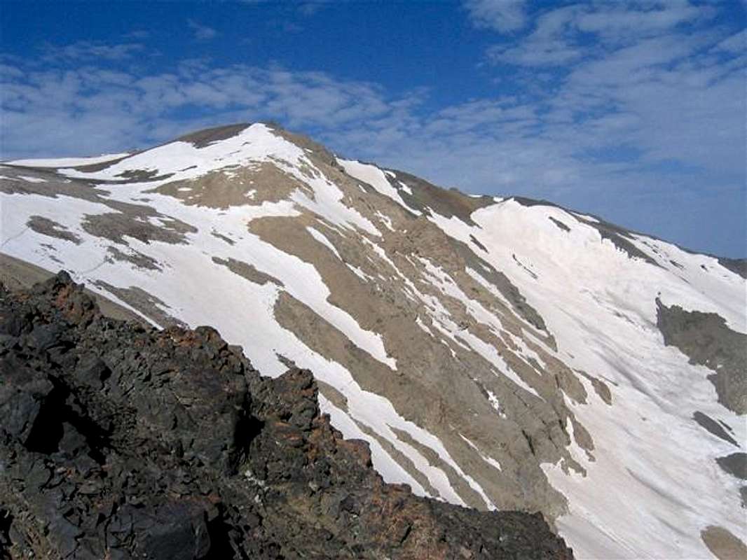
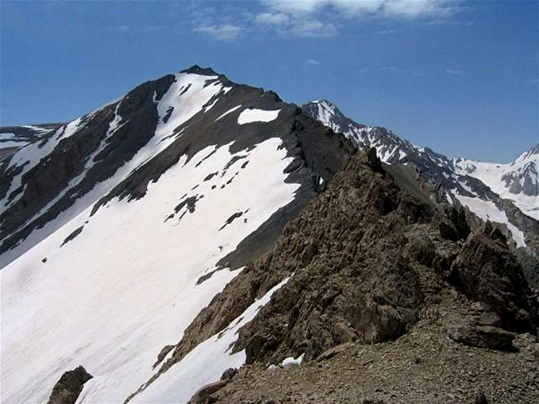
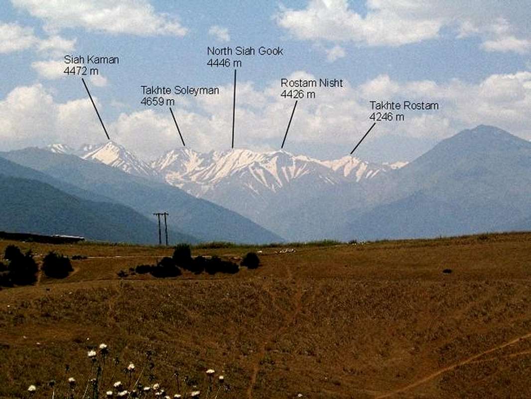
The crest of the Takhte Soleyman Massif is made of a 19 km (12 mile) long ridgeline that runs north-south and is entirely above 4000 m (13123 ft). In the mid/northern portion of it, the ridgeline creates a small triangular plateau that is more than 4300 m (14100 ft) high and drains to the north. While the 4446 m (14587 ft) North Siah Gook Peak rises in the southern portion of the plateau, Rostam Nisht Peak marks its northwestern boundary. From the surface of this plateau, Rostam Nisht appears as a “hill” with three pointy summits.
Unlike the short eastern slopes that rise above the plateau, the scree covered western slopes of Rostam Nisht drop 2000-2500 m (6500-8200 ft) to the bottom of the Sehezar Valley. To the north, Rostam Nisht is connected to the 4246 m (13930 ft) Takhte Rostam Peak.
If you are in good shape, you might be able to climb Rostam Nisht in a single day. This, however, requires a 2100 m (7000 ft) vertical gain. From the Vandar Bon Village (see Route) you will hike to the Sar Chal Shelter (3750 m, 12300 ft) which is often used as an overnight sleeping spot by those who go to climb the highest peak of the massif, the 4850 m (15912 ft) Alam Kooh Peak. Going up the slopes above the Sar Chal Shelter will get you to the mentioned plateau and the eastern slopes of Rostam Nisht. The plateau can also give easy access to North Siah Gook Peak.
From the summit of Rostam Nisht Peak you can hike north past the Takhte Rostam Peak and onto the 4412 m (14475 ft) Kalahoo and its nearby peaks (see “From Rostam Nisht” Route on Kalahoo Page).
The summit of Rostam Nisht can provide you with great views of the mid and northern peaks of the Takhte Soleyman Massif. The best view, in my opinion, is that of the Haft Khan Peaks and Haft Khan Glacier. The very long and steep drop to the bottom of the Sehezar Valley spices up this view even further.
 |  |  |  |  |
Getting There
See Map.
From downtown Tehran drive 40 km west to the town of Karaj and take the Karaj-Chalus Road north (This road crosses the Alborz Mountains taking you through the Kandovan Tunnel to the Caspian Coast). 30 km south of Chalus, you will reach the town of Marzan Abad. Turn left and follow a side road into the Sardab Rood River drainage and to the town of Roodbarak. Distance from Tehran to Roodbarak is roughly 200 km (125 miles)
 |  |  |  |  |
Red Tape
I am not aware of any permit or fee requirement. Hunting will require a license.
When To Climb
June to October is the ideal season. Climbing in winter will obviously be much harder due to extreme cold and heavy snow cover.Camping
Accommodations are available at the Iran Mountaineering Federation Hotel in Roodbarak (call Mountaineering Federation at 98 21 256 9995-96) or camp anywhere.Mountain Conditions
In summer, the weather is generally clear. Unexpected thunderstorms do occur frequently. Precipitation at higher elevations will almost always be in the form of snow/hailMiscellaneous Info
TOURS/GUIDES:If you are not familiar with these mountains, you will greatly benefit from the presence of a guide. I worked with Araz Adventure Tours and was very satisfied with their services. They were flexible, courteous and knowledgeable and were able to custom design an 8 day trekking tour allowing me to climb the lesser known peaks of the area. My guide: Mr. Rasool Naghavi was a kind man who was a native of Roodbarak and knew the mountains like the back of his hand. Having climbed Everest and several other Himalayan giants made him, in my opinion, one of the most qualified guides for these mountains.
MAPS:
1) The most accurate topographical maps of the area are those with a scale of 1:50 000 (contour lines of 20 m) provided by the Iranian Armed Forces. You will need sheet #6162 I "Shahrestanak" for Alam Kooh (To fully cover the entire Takhte Soleyman Massif, you will also need sheet #6262 IV "Rudbarak"). These maps are available in Tehran at the Geographical Office of the Armed Forces on Moalem St. (98 21 8408088) for the equivalent of $3 per sheet (in 2004). Outside of Iran, the same maps can be purchased at www.cartographic.com for the exorbitant price of $150 per sheet (in 2003). These maps are in Farsi. While they give the exact elevation of most of the peaks, they do not give the names of the individual peaks.
2) Soviet Military Maps sheet # J-39-126-G available at www.omnimap.com. I do not recommend this map. It seems as if the creators of this map lacked detailed info and eliminated many of the lower peaks.
3) Different schematic maps available in Iran. My favorite is the "Guide Map of Takht-e-Soleiman & Alam Kuh Region" by Iran Kuhro Co. available at Varzesh Kooh store, Ferdowsi Sq., Tehran (98 21 8826642).