
|
|
Area/Range |
|---|---|
|
|
46.81300°N / 87.871°W |
|
|
1981 ft / 604 m |
|
|
Overview
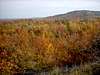
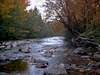
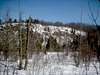
The Huron Mountains encompass THE most wild and rugged territory in Michigan. It is a region of low, yet surprisingly rugged mountains, swamps, lakes, and high plateaus. It is because this is such a large and diverse region that I decided to devote a page to the entire range in addition to the two prominent peaks already on this site (Arvon & Hogback). The majority of peaks in this area are unnamed and for the most part inaccessible. I have spent many years living near them, spent countless hours and days exploring them and feel like I've barely scratched the surface. The region has become increasingly popular with climbers in the past few years for its numerous granite cliffs. You'll need a local to find them though:)
The Huron Mountains are the largest range of mountains in Michigan yet they are not listed on any map. The boundaries of the range are vague but generally include the area north of US-41 between Marquette and L'anse. This is approx. a 1000 sq. mi. chunk of real estate without a single paved road.
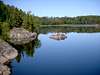
The Hurons can be divided up into three ranges. The Arvon Range includes the highest peaks, Mount Arvon(1980') and Curwood(1979'), in the state of Michigan. The Arvon Range runs generally north-south in eastern Baraga County. The most rugged section, The Huron Range, runs northwest-southeast to the west of Big Bay in northern Marquette County. The highest peak in this region is Ives Hill at approx. 1400 feet. This part of the mountains has the most rugged relief, the highest waterfalls, and the prettiest lakes. Unfortunately a good chunk of it privately owned by the uber-exclusive Huron Mountain Club and is off-limits to the general public. The third region is the most accessible, the Marquette Iron Range. This region runs from Lake Superior at Marquette west to the Lake Michigamme area. Hogback Mountain(1200'), listed separately, is part of this range but numerous unnamed peaks to the west rise to over 1700 feet.
 |
 |
 |
 |
 |
Getting There
Getting to the Huron Mountains is easy, getting around them is a bit more difficult. The main artery for the region is US-41. From US-41 you can head north along the eastern edge of the Hurons from Marquette along County Road 550 or the western edge from L'anse along Skanee Road.
Numerous logging roads leave US-41 north into the Hurons but most of these don't penetrate more than a few miles before ending at a stream or bog. There is one, County Road 510 that runs from US-41 north 35 rough miles along the edge of the ridge to Big Bay where it ends at County Road 550.
There is only one road that penetrates through the heart of the range. It is known as the AAA road although you will find few if any signs demarking it. It leaves County Road 510 about 4 miles from its north end and winds its way across the Hurons 30 miles to the end of Skanee Road. There are two things I recommend when traveling this road...4-wheel drive and A VERY GOOD MAP!! It should be noted that the AAA road is not plowed in the winter.
 |
 |
 |
 |
Red Tape
The majority of land is Paper Company land and they generously allow almost unrestricted public use. There is one big exception though. That is the Huron Mountain Club. As previously mentioned they own around 20,000 acres of some of the nicest scenery in the mountains. Back in the 50's the government was considering making this area a National Park but the deep wallets of the club members convinced them otherwise. To this day the property is strictly off-limits and they do patrol the unfenced boundaries on a regular basis.
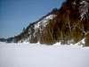
The other problem you will encounter is the climate. Snow arrives early in these high elevations and stays late. Roads may be inaccessible by early November and be snow-covered well into May. 200 to 300 inches of snow falls here each winter and by March it can sit 4 to 5 feet deep! All that melting snow in the spring makes for about a month-long mud season where the roads may be open but you'll need a monster truck to get through some spots. This may seem harsh, and it is, but it keeps this region the beautiful, peaceful place it is.
 |
 |
Peaks to Explore
Mount Arvon (1980') is the highest point in the state of Michigan. It's not as hard as it once was to get to, which is nice due to the lack of views at the top. Its located in northern Baraga county in the northwest Hurons.
Hogback Mountain (1220') is a locally well known yet seldom climbed peak in the southern Hurons. Its bare, rocky summit affords 360' views that are very hard to come by on a mountain peak in Michigan.
Little Mountain (1150') is a peak that lies just south of L'anse but is virtually unknown. Don't let its diminutive size stop you from visiting, the panoramic views of the Huron Mountains and nearby Keweenaw Bay are amazing!
When To Visit
As described above winter effectively closes off the Huron Mountains. If you have access to a snowmobile you can still get pretty much everywhere however. May and June is bug season and depending on how wet the spring is can be almost unbearable. The best time to visit is July until the first snow. Leaf season (September) is especially beautiful.
 |
 |
 |
 |
 |
Camping
Camping is allowed anywhere unless otherwise posted. Modern camping can be found at Perkins Park in Big Bay, the Marquette Tourist Park, or Van Riper State Park in Champion.
Conditions & Info
Here are a couple local contacts to help you around the region...
Michigan DNR (Ishpeming): 906-485-1031
Marquette County Visitor Info: 800-544-4321 or see link
Baraga County Visitor Info: 906-524-7444 or see link
For climbing and trail info...
Downwind Sports(Marquette): 906-226-7112 or see link
 |
External Links
- Baraga County Tourism & Recreation Association
A good page for info on Baraga County. These people have been an invaluable help for getting around this area. - Marquette Country Convention & Visitors Bureau
Good source of info for Marquette County - Downwind Sports
Marquette's best outfitter and a great contact for climing info in the area - Marquette National Weather Service Office
The best place to find weather info for the UP. - Northwoods Cam Network
Webcams from all over the region. - Big Bay Area Webpage
Lots of helpful links for the Big Bay area of the Huron Mountains. There are a couple outfitters here that provide guide services into the Hurons.
DWhike's Adventures - Shameless self promotion...come visit my website for more pics of the Huron Mountains and other places that I have wandered off to in recent years...