
|
|
Area/Range |
|---|---|
|
|
43.30000°N / 20.80000°E |
|
|
6617 ft / 2017 m |
|
|
Overview
Kopaonik
"Sunny Mountain"
KOPAONIK mountain is known as a "SUNNY MOUNTAIN", because that have more than 200 sunny days per year.
Kopaonik, the biggest mountain of the central Serbia, spreads its wide mountain-ridge 82.7km long, its greatest width being 63km, in the direction from the mountainous region over Kosovska Mitrovica, to the north-west over the series of peaks higher than 1600m, to the highest part of the massif called Ravni Kopaonik (Flat Kopaonik) with the peaks: Gobelja (1934m), Karaman Vuchak (1936m), Suvo Rudishte (1976m) and Panchichev Vrh (Panchich's Peak) (2017m).
 Pančićev Vrh (2017 m
 The northern border of the massif is separated from the massif of the mountain Zeljin by the rivers Joshanicka reka and Koznichka reka. At the western side, along the whole Kopaonik mountain-ridge, the river Ibar gorge is placed. The eastern side is bounded by the rivers Rasina and Toplica valleys. It is very spacious, taking up a full 2756 square kilometers.
Kopaonik was declared a national park in 1981. The national park spreads over 120 square kilometres - 12000 hectares. A vast high mountainous and relatively flat region at an altitude of about 1,700 meters forms the basis of this national park. This central Kopaonik plateau is called Suvo Rudishte. It is surrounded by mountain peaks. To the north and northwest of this plateau stretches Banjski Kopaonik below which is the well-known Joshanichka Banja with its strong springs whose waters reach the temperature of 88 degrees Celsius. Directly below the Suvo Rudiste plateau starts the attractive and picturesque valley of the Samokovska River, characterized by its steep run, numerous rapids, falls and gorges.
By its geographical location, Kopaonik is predestined to be a large to Europe. The Ibar, Zapadna Morava and Toplica highways provide for easy access from the large industrial centers of Shumadija, Pomoravlje, Toplica, Kosovo and the Skopje valley (Skopska dolina). Due to good asphalt roads and railways, the mountain can be reached in five hours' time even starting from Belgrade, which is about 250km away.
In its highest part, Kopaonik somewhat resembles a flat-roofed house; its side are almost wall steep and the top so level that it induced the people to aptly name is Flat Kopaonik (Ravni Kopaonik). The western sides of the mountain are a little steeper than the eastern, but also more inaccessible and bare. Kopaonik is rich in cold and radioactive waters at higher altitudes and hot ones in the lower parts.
 The mountains of Montenegro from Pančićev Vrh
Among Serbian-Montenegrin mountains, Kopaonik is unrivalled by its natural beauty and mineral wealth. The duration and quality of snowfall and ideal skiing grounds have been attracting a rapidly increasing number of guests. Its boundaries are set by quite distinct natural borders-the deep valleys of the Ibar, Joshanica, Rasina, Gornja Toplica and Lab rivers.
The main features of Kopaonik relief were formed some 70 million years ago. Great movements of the earth's crust brought about folding and strong splitting, cleaving the steep sides facing the bordering valleys. Longitudinal and transversal fissures dissected to a large degree, the interior parts of the mountain as well. Deep clefts thus formed created a path for the flow of andesite-basalt rock, giving birth to the most extensive eruptive mass in Serbia, and therefore to great mineral wealth-the most important ores (iron, copper, lead, silver and other metals) are linked with dacites and andesites. Chromium and magnesium ore deposits formed in the serpentine-peridotic rock. Erosion created the wide plateau of Ravni Kopaonik and the highest peaks from the more resistant rock. Cascading rivers and snow carved rugged valleys in the areas of softer, especially serpentine rock, which is dominant in the western region of the mountain, increasing, therefore, the slope, inaccessibility and picturesque quality of the terrain.
Kopaonik, where people used to work mines from old times, was named after its ore resources ("kopati" - "to dig"). The volcano activity and discharge of hot mineral solutions caused changes on the nearby old rocks because of high temperatures and heavy pressures. That is how "mining region of Kopaonik" came to be, with a large numbers of mines from old times. In Kopaonik region, besides the usual ores: metals iron, lead and zinc, there are rare metals silver and gold and rare minerals: volastonite, fluor-spar, asbestos and other.
The process of erosion has created interesting forms of relief, which attract the attention of nature lovers. Some are made of granite and look like giant heads of cabbage, weighing two to three tons, falling apart and splitting as if shedding their shells. They can be seen in several places along the Joshanicka Banja-Ravni Kopaanik road. Others are a potpourri of rocks of unreal beauty, like the Kozje Stene on the slopes of Kukavica and along the left bank of the Samokovska River. Third are groups of oddly aligned or scattered blocks of large-grain granite, resembling giants turned to stone. Such an example is Markov Kamen (Marko's rock), "the most beautiful geomorphological natural rarity" on Kopaonik.
 Šar Planina from the summit of Pančićev Vrh
Natural monuments: Geomorpholigical monuments - stone granite sculptures: Lisicja stena, Pajin grob, Suvi vrh, Jankov breg, Babin grob, Visoki deo, Karaman-Vucak. Geomorphological monuments-traces of Pleistocene glaciation: Circ Krcmar, Circ Shiroki Do, Circ Velika Gobelja. Geological monuments: Velika stena, Velika Sijaca, Jelica, Zljeb, Gvozdac, Oshtri Krsh. Hydrological monuments - springs and fountainheads: Fountainhead Duboka, "Geyser" Gvozdac, Spring Marina voda, Spring Krcmar, Waterfall Barska reka, Semeteshko jezero-lake. Hydrological monuments - strictly protected water courses of the river basins: Samokovska reka, Gobeljska reka, Barska reka, Brzecka reka, Duboka reka.
This mountain has enormous resources for the development of tourism. The entire national park is characterised by its extraordinary natural beauty: vast expanses of grassland, picturesque forests composed of a wide variety of tree species, beauty spots, deep river gorges. The snow blanket lasts a long time on this mountain (from November till May) and in view of its good relief, there are excellent conditions for the further expansion of winter (ski) tourism there.
The tourist resort on the Kopaonik includes hotels, rest houses, ski lifts, excellent ski slopes (more than 40 km) and many other tourist facilities.
About Serbia
Geographical position:SERBIA is situated in the center of the Balkans, on the most important roads, which connect Europe and Asia, and covers the territory of 88.361 square kilometers. The length of the borders is 2.397 kilometers. In the east it borders upon Bulgaria, in the northeast upon Romania, in the north upon Hungary, in the west upon Croatia and Bosnia and Herzegovina and in the south upon Albania and Macedonian.
Serbia is the crossroads of Europe and geographically and politically important territory. International roads and railways, which pass down the valleys of its rivers, are the shortest connection between Western and Central Europe, on one side, and Near East, Asia and Africa, on the other side.
Serbia is in CET- central Europe time zone (GMT+1hour). Summer time is from the end of March till the end of October (GMT+2 hours).
Capital: Beograd (Belgrade): over 2.000.000 citizens
Currency: Dinar
Relief:
North Serbia, Vojvodina, is mostly a plain, while Central and South Serbia are hilly and mountainous. 15 of the mountain peaks reach the height of over 2000 meters, and the highest is Djeravica (2656 m) - (now on territory under UN protectorate) on Prokletije. Serbian rivers belong to the basins of the three seas- Black Sea, Adriatic Sea and Aegean Sea. Three of them are floatable: Danube, Sava and Tisa. The longest is Dunav (Danube). Its total flow is 2.857 kilometers and it flows 588 kilometers through Serbia.
Climate:
The climate in Serbia is temperate and continental with nuance between the four seasons. Summers are hot and winters are cold and snowy.
Population:
There are 7.478.820 inhabitants in Serbia (not counting Kosovo and Metochy), and that’s 94.1% of the entire population of Serbia&Montenegro. Serbs make 66% of the inhabitants, Albanians 17%, Hungarians 3.2% and then there are the Romanians, Romes, Slovakians, Croatians, Bulgarians, Turks, etc. The population is mostly of the Orthodox Christian faith. However, there are other religious communities: Islamic, Catholic, Protestant, Jewish, etc.
Language and letter:
In Serbia people use Serbian language of aecavic and iecavic pronunciation. It belongs to the group of south Slovenian languages and it is most similar to Bosnian, Croatian and Macedonian languages. A great number of our words are of a foreign origin, mostly Turkish and German, but today there are more and more anglicisms. Serbian language consists of 30 voices and two letters - Cyrillic and Latin characters. What makes it unique among other languages is a simple rule by which it is written and read: one letter for each voice and vice versa. You will mostly meet Latin characters, but the names of the streets and the information at the bus and railway stations and at post offices are written in Cyrillic. Therefor, it would be very useful if you learned the capital letters of Cyrillic, at least. Most of the young people speak English, less German, French and Russian, but Spanish and Italian are getting more and more popular, every day.
Getting there
By plane:- To Belgrade/Beograd airport, distance about 250 km from Kopaonik mountain.
- To Nis airport (read "Nish"), closer to Kopaonik than Belgrade airport.
Than, from Belgrade or from Nis town - to Kopaonik by bus or car.
Also, everything about flights and tickets you can check on JAT Airways web site.
By bus:
- Belgrade - Kopaonik (about 250 km, 5 hours by bus)
- Nis - Kopaonik (1-2 hours by bus)
By car:
- Belgrade-Kraljevo-Joshanichka Banja-Kopaonik (259 km)
- Belgrade-Krusevac-Brus-Kopaonik (279 km)
Kopaonik is well-connected with the main transport routes in Serbia. The central part of Kopaonik with the tourist center and ski slopes is linked with the Ibar Highway by a modern tarmac road. The nearest airport is in Nis town.
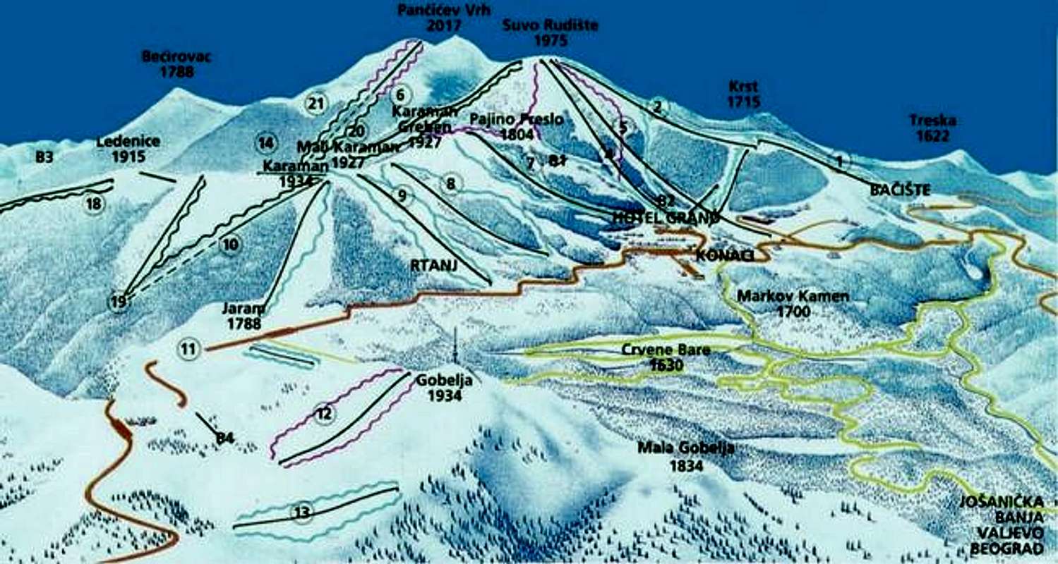
Map of Kopaonik massif
When To Climb
Kopaonik is mountain for hiking, long distance backpacking, climbing, mountainbiking and, of course, for skiing, snowboarding, paragliding and many other activities.On Kopaonik mountain you will find snow during November-May period. During whole year you can visit this beautiful mountain in Kopaonik National Park.
Camping
No camping fees for paying. On the mountain you can choose place for camping from many places inside of Kopaonik massif.Mountain huts:
~ Mountain home Dr. Petar Kostic (1734m)
Place: Region "Pajino preslo"
Configuration: Building with ground-floor (dining room) and first floor (rooms)
Capacity: 22 beds. Two double-bedded and three six-bedded rooms.
Conveniences: Electricity, water supply, near by there is springwater. There are bathroom and two toilets. Kitchen is well supplied with all needed dishes and eating utensils. There are electric heaters in rooms and in the dining room.
Environment: Near by there are cable railways which cover all skiing fields in this part of Kopaonik (Suvo Rudiste, Karaman, Gobelja.). There are other tourist and catering objects too.
Arrival: Home is 10 minutes away from "Konaci".
Administrative office: PSD "Avala", Belgrade, Francuska street No 32-a.
Contact: Miodrag Radoicic, phone: +381 11 186719
Lodgings: Home is opened during all year.
~Mountain hut Kopaonik (1720m)
Place: Near by "Konaci", at spring Marina voda (Mara's water) and cable railway Karaman.
Configuration: Building with ground-floor (dining room), first floor and attic.
Capacity: 50 beds in four-bedded and multi-bedded rooms.
Conveniences: Electricity, water. On every floor there is bathroom with hot and cold water. Every room has washstand with hot and cold water. As part of the dining room there is a little kitchen with boiler, dishcloth and refrigerator, so it is possible to cook or store smaller amounts of food, TV.
Arrival: You should take the road "Ibarska magistrala" until you get to the Biljanovac, across Josanichka banja, or from Krusevac and Prokuplje across Brus and Brzece. You can also take the train for Raska to Rudnica and than another 20 km across Makadam's road.
Administrative office: PSD "Kopaonik", Belgrade, Brace Jugovica street No. 19.
Contact:
- phone of the home: +381 36 71190
- Milomir Miladinovic, Kraljice Katarine street No. 74-a, phone: +381 11 544063
Lodgings: Home is opened during all year, and it has its janitor. During ski-season, ski-schools and competition teams have advantage.
~Mountain home Rtanj (1876m)
Place: Under the peak Karaman.
Configuration: The biggest mountain home in our country, it has three floors.
Capacity: 180 beds. 46 double-bedded to six-bedded rooms and 4 eight-bedded to fourteen-bedded rooms.
Conveniences: Home is in the rank of "B" category hotel.
Environment: Complex of cable railways which connects all ski-fields on Flat Kopaonik.
Arrival: Home is 15 minutes on foot away from "Konaci". There are direct bus lines from all bigger places in Serbia.
Administrative office: Private owner (rent), and owner is PSD "Rtanj", Belgrade, Bulevar Revolucije street 73.
Contact: phone: +381 36 71090 (head-office).
Lodgings: Home is opened during all year.
Price: There are market prices in the home and mountaineers doesn't have any benefits.
Mountain Conditions
5 and 7 days weather forecast for Kopaonik on this two pages:Kopaonik weather forecast 1
Kopaonik weather forecast 2
Maps
 |  |