
|
|
Mountain/Rock |
|---|---|
|
|
47.57000°N / 24.76000°E |
|
|
6719 ft / 2048 m |
|
|
Overview
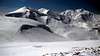
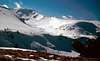
Varful Galatau (Varful = Vf. = summit) is one of the lower, but still over 2000 m high, peak in the east part of main ridge of Muntii Rodnei. It offers great panoramatic views to the highest peak Pietrosului, to the valley of river Viseu with C.T. Borsa, Maramures mountains, and around. In fact, views are tens of kilometers away.

The peak is situated between passes Saua Laptelui on the west, and Saua Galatului on the east, both of them are simply accessible from the former Cabana Puzdrele (camping site is there today) that you can reach from C.T Borsa. Moreover, longer access is on the east via Saua Gargalau. Vf. Galatalui is usually reached during the crossing whole Rodnei mountains as for one day trips people prefer Vf. Gargalau or Pietrosul. North slopes are steeper and rocky, whereas south slopes are moderate.
General description of Rodnei mountains is at SP Muntii Rodnei Group
 |  |
Getting There
a) by car from Hungary Satu Mare - Baia Mare - Viseu du Sus - Borsa, continue up to Passul Prislop, from the east Vatra Dornei, route No. 18
b) by train to Viseu du Sus, then by bus or hitchike to Borsa or to Passul Prislop
More detailed description about getting there is at Muntii Rodnei Group
Red Tape
Rodnei mountains are part of Rodnei National Park and you are allowed to camp only in several passes. There are also some other reservations with higher protection.
Pietrosul Mare area in UNESCO network of world biosphere reserves
Description of Rodnei National Park at www.parks.ro
When To Climb
Vf. Galatau is accessible all the year with appropriate equipment, in the summer classic tourist equipment together with waterproofs for rainy June/July period. All items of avalanche safety equipment are needed during the winter time especially if you are riding on skis or snowboard.
Do not forget that Romanian mountain rescue team SALVAMONT take care only in summer, whereas in winter you can find them only in ski resorts - here at Borsa ski slopes.
Camping
Cabana Alpina (1413 m) - Passul Prislop, 6 beds, camping site, phone: 0262/342425
Puzdrele Hut (1540m) – burned, today only camping site
Saua Gargalau (1907 m) – camping near the pass
under Cascada Cailor – camping site
Route overview
Marked tourist paths to Saua Gargalau:
a) Pasul Prislop (1415 m) - Saua Gargalau (1907 m) - red triangle
b) Complex turistic Borsa (845 m) - Cascada Izvoru Cailor - Poiana Stiol (1572 m) - Saua Gargalau (1907 m) - red triangle
c) Complex turistic Borsa (845 m) - Poiana Stiol (1572 m) - Saua Gargalau (1907 m) - blue strip
d1) Poiana Borsa - Valea Negoiescu - Cabana Puzdrele - Saua Galatului blue triangle
d2) Saua Buza Muntelui – Cabana Puzdrele – blue circle to Cabana Puzdrele, then route d1)
non-marked paths:
A1) from the north through the valley above Cascada Izvoru Cailor, access from Stiol traversing unnamed end (1825 m) of the north ridge from Saua Gargalau to the valley of Izvoru Cailor, then via the wide couloir to the main ridge.
A2) from the valley of Izvoru Cailor ascent on the right ridge (see Valley and right ridge) and on the ridge to the smaller summit - beautiful views to valleys of Izvoru Cailor and Cimpoiasul.
B) from the south through the Izvoru Gelatului and Izv. Gepetu valleys, at the end of valley road turn to the left. From the beginning a steep ascent leads through the forest, then on moderate slopes to the summit.
Highly recommendable are paths a) or A1), A2) via waterfall Cascada Izvoru Cailor. It is about 80 meters high. In winter we suppose the height of Cascada Cailor is about one rope, i.e. 60 m as the lowest part of waterfall was hidden by avalanche, whereas Romanian told on their Cascada Cailor ice-climbing page that it is about 100 meters high. Marked path to the waterfall was renowated by a group of French and Romanian mountain lovers in 2002.
Weather forecast is only in Romanian: Salvamont weather
Mountain Rescue (SALVAMONT) contact is:
Consiliul Judetean Bistrita - Nasaud
Serviciul Public SALVAMONT
Phone : 0263/215503
Fax : 0263/214750
Email: salvamont_bn@yahoo.com
WWW: Serviciul Public Salvamont Bistrita - Nassaud
Salvamont Rodna - southern part , phone : 0263/377090 or 0740/652854
Salvamont Borsa - northern part , phone : 0262/342322
Salvamont Nasaud - western part , phone : 0740/651941
Maps:
1. Online map:
Harta Muntii Rodnei at alpinet2k.alpine.org
2. Good source of scanned maps that are not available in shops:
Map server
 |  |
Highest peaks of Rodnei mountains
1. Vf.Pietrosul 2303 m
2. Vf.Ineu 2279 m
3. Vf.Rebra 2268 m
4. Vf.Ineut 2222 m
5. Vf.Grohotu 2203 m
6. Vf.Puzdrelor 2189 m
7. Vf.Laptelui Mare 2172 m
8. Vf.Gargalau 2159 m
9. Vf.Omului 2134 m
...
xx. Vf. Galatau (2048 m)
General description of Rodnei mountains