
-
 14670 Hits
-
 86.37% Score
-
 22 Votes
|
|
Mountain/Rock |
|---|---|
|
|
42.61060°N / 19.59590°E |
|
|
7027 ft / 2142 m |
|
|
Geographical structure
Dinaric Alps 4 Central Belt 4 Površi i brda (Highlands and mountains) area of Montenegro 4 Kučka krajina mountains 4 Northern Section 4 Maglič (Kučki)Overview
In commerce you would call it „the best buy“ – an easy climb, for a magnificent view. Such description stands completely for Montenegrin mountain Maglič (Kučki) (read: Maglich Kuchki - where both „ch“ are like „ch“ in beach) in upper Kuči area (Kuči are Montenegrin clan) a northern part of Kučka krajina mountains.Because there is another mountain in Dinaric Alps with almost similar name (Maglić) on border between Montenegro and Bosnia&Herzegovina, the mountain presented on this page, as a part of Kucka krajina mountains GROUP, is often called Maglič kučki (Maglič of Kuči, transl.) or some are even saying Maglič prokletijski (Maglič of Prokletije, transl.).
The main feature of Maglič (Kučki) is a huge 5 kilometer long, central, grassy ridge with the highest summit Veliki Maglič (Greater Maglič) reaching 2,142 meters. South-east of the main summit and still a part of the same summit ridge, is the second highest peak Mali Maglič (Small od Lower Maglič, transl.), 2,070 m.
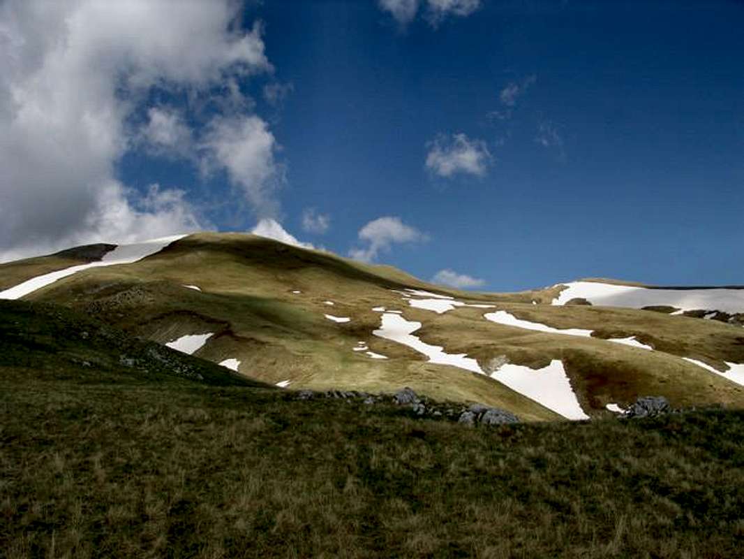
Western slopes of Maglič mountain, just below its main summit Veliki Maglič (2,142 m)
The ridge and the mountain itself are connected (at lower altitude) to N, over Kozelj (peak at 1,981 m), Kurlaj pass, Planinica mountain and Suvivrh with Komovi mountain, in W direction to Crna planina (Black mountain, transl.), and in SE over Sirokar plateau/pass to other mountains of Kučka krajina group.
In all other directions grassy slopes of Maglič descend (on some places in form of rocks) to carstic fields or river valleys of Veruša (Mokro field and katun), Opasanica, Vucji potok (Wolf´s stream, transl.), Bindža and Vermosh on eastern side.
This mountain and surrounding hights are the place where rivers Veruša, Vermosh and Opasanica spring out and from where they get the most of theirs waters (Opasanica and Veruša will finally join their waters NW of Maglič to make famous Tara river).
The main ridge stretches in NW-SE direction, thus following predominant direction in Dinaric Alps, but this is an excemption here in this part of Dinaric Alps and Prokletije range overall, where mountains do not follow one predominant directon. Also the mountain is not too compact, since around its main ridge there are more steps-like plateaus and rounded ridges in all directions.
Maglič is mostly treeless. Trees grow only around its foot, close to neighboring river valleys or fields. So, during your climbs you will probably have no problem with orientation. For example, the most popular mountain trail leading from katun Širokar Ljakovića to the summit was marked years ago, and those marks have faded until today, but the summit or any of your other targets are visible for the most of time you walk this mountain. Also you will for sure notice more traces on the ground or in the grass, made by people that have visited the mountain before you, leading mostly in direction of the summit, or from one katun to another.
Because of its isolated position, «lack» of trees and wide slopes separated by river valleys from other mountains, Maglič (Kučki) is a place with some of the best vistas (views) in the area! I should describe the position of this mountain as a center of an amphitheater.
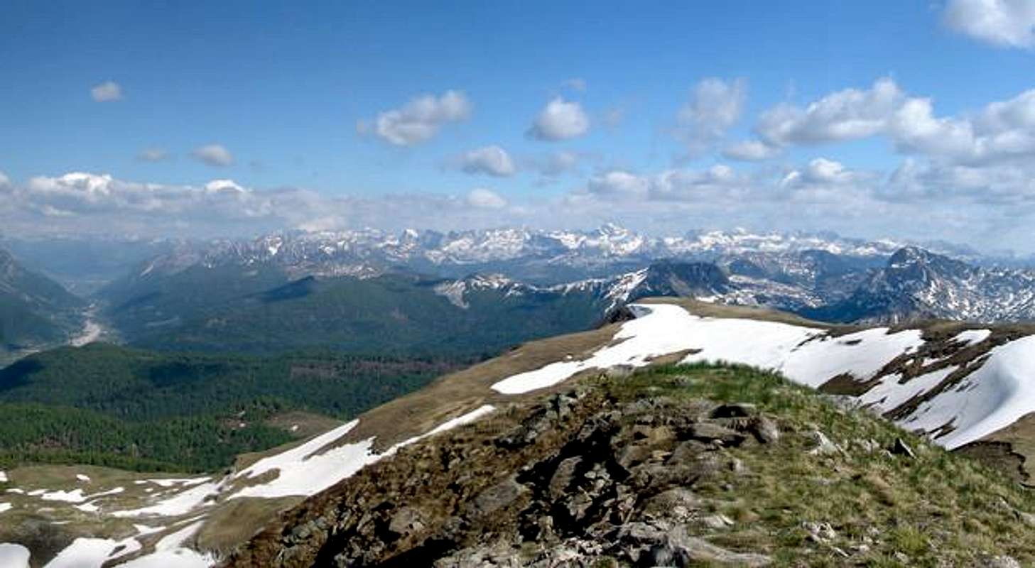
And although this mountain seems to have „monotonous“ morphology, the views from its summit and during each of approaches are magnificent. Starting from north - clockwise - one can observe Komovi, Planinica mountains and range of border mountains ans summits (between Montenegro and Albania), all the way to Visitor mountain, Plav-Gusinje-Vermosh valley and mountains of eastern part of Prokletije (Čakor, Bogićevica), central part of Prokletije range (Vezirova brda, Bjelič, Krošnja, Karanfili, Maja Jezerce), other sections of Kučka krajina mountains - especially its eastern part and central cluster with the highest summit Surdup, and finally to the west, the mountains of Central Montenegro around Morača river so called Morača mountains (Moračke planine, orig.) can bee seen.
Like the most of Kučka krajina mountains it is also here where influences of warm and humid air penetrate from Mediteranean (Adriatic) and mix with colder continental air, so many times on passes or other exposed places on Maglič you will experience stronger or lasting winds. And many times too, Maglič and Komovi mountains will be in the first line of mountains that are fully covered by clouds, or where it rains, while neighboring Mediteranean areas would experience humid, sunny and warm weather. So its not surprise that the mountain probably got its name from lokal word for fog („magla“ -> maglič).
The climbs over the mountain are easy, and the bigger problem is how to get to the foot of the mountain if you are dependent on public transport only - but if you like to walk this is not problem, of course.
Maglič is accessible by non-paved road starting from Veruša settlement and then the same road encircles the mountain from its west, south and east ides, passing through katuns Mokro, Širokar Ljakovića and continues in direction of Komovi mountains over wooded area of Kozelj, Kurljaj and katun Carine.
Mountaineers/hikers often pass over Maglič or close to it when they walk longer-distance trails from Komovi (over Kurlaj pass, Bijele vode and katun Carine) to Kučka krajina mountains and Veruša (or vice versa, of course), following a section of Montenegro mountain trail No. 1 (Crnogorska transverzala, CT-1.
Because of abundance in grassy meadows, Maglič used to be very popular among shepherds and it was used for some centuries by brotherhoods (and families) of Kuči clan who came here to live, over summer, with their livestock.
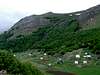
On and around Maglic you can still find clusters of shepherds huts (stan, singular) positioned close to pastures. Such cluster is locally called katun (katuns, plur.). Just to mention some of them on Maglič: katun Prouški, Krivodoljski, Zagon; Bušar and Maglič katun and on the edges of the mountain are katuns Mokro and Širokar Ljakovića.
What used to be katuns before, Veruša nad Mokro have nowadays become predominantly weekend-house settlements.
Panorama from Veliki Maglič in SE direction, from Vermosh-Plav-Gusinje valley (on the left), over central part of Prokletije mountain range, to the easternmost mountains of Kučka krajina mountains GROUP (pyramide shaped Vila 2,093 m)
Getting There
The most convenient ways to get to Maglič is to approach it, by any kind of vehicle or by foot, from Veruša village by abovementioned non-paved road or another road from Podgorica, via Ubli. Other approaches are from direction of Komovi mountain in the north or from other mountains of Kučka krajina (from south), but those approaches include longer hikes.So like for the rest of the GROUP, the best approach to Maglič is to use your own vehicle (bike, car, bus) since public transport is limited.
1. To get to Veruša
To get to Veruša by bus
Veruša is the closest you can get by bus (and public transport anyway).
Bus connection from Podgorica to Veruša (via Lijeva Rijeka: 2 times a day at 07:00 and 14:20 h, maintained by "Minić - prijevoznicko preduzeće" (read: Minitch) transport company, every day MON-SUN. Departure: Podgorica main Bus Station. Info at: ++381 81 621 923 (you are much in advantage if you understand local language).
To approach Veruša by car/bike you can use one of two roads:
1. Podgorica – Bioče (Bioche) – Lijeva Rijeka – Veruša
2. Kolašin (Kolashin) or Andrijevica – Mateševo (Mateshevo) – Veruša.
To approach katun Mokro by car/bike you can use the road Podgorica – Ubli – Kržanja (Krzhanja) – Gornje Stravče (Gornje Stravche) – Bukumirsko lake – katun Mokro. The last 10 kilometers of this road are not paved.
To approach Veruša by train
Very attractive Belgrade-Bar railway passes by western outskirts of the Mountain group. There are more stations close to Kučka krajina, but except Podgorica you will have problem to find convenient public transport from those stations to Verusa. All stations have 3-4 trains a day in each direction (north or south) and Podgorica and Kolašin even more, 6-9 per day.
The stations to choose are: Podgorica, Bioče, Selište, Mateševo. Selište is the closest one to Veruša.
Best information on train schedules at:
Serbian Railways-homepage (search under „Passenger Traffic“, then „Train Sequence table – Stations Timetable, then choose your stations).
Serbian Railways-direct access to Station Timetable.
To get to the area by plane
The most appropriate way to arrive by plane is to Podgorica airport:. The airport stil has no web-site so try to get info on the sites of two biggest airline companies that operate to and from Podgorica:
Montenegro Airlines
JAT – Yugoslav Airlines
Belgrade Airport - for flights between Podgorica and Belgrade and between Tivat and Belgrade.
There are also other possibilities to arrive by plane but it will take you more time to travel from there to Kučka krajina. They are Tivat Airport (Montenegro) and Dubrovnik Airport (Croatia).
2. To get to the foot of the mountain
Staring your move (by car, bike/foot) from Veruša by non-paved road you will be able to take off this road and start your climb to Maglič, from many points. The most popular routes start from katuns Mokro and Širokar Ljakovića directly to the summit or from Mokro via Bušar katun. Since the road encircles the mountain you can also test your orientation skills and begin your climb by taking off the road at any other point.
You can also approach the mountain from direction of Komovi mountain (from north) by already existing hiking trail. For info how to get to Komovi see Komovi SP Page.
If youre approaching the mountain from the other parts of Kučka krajina mountains GROUP (from S, SE, W) you will have to cross over the previously mentioned encircling non-paved road, where from you can begin your Maglič climb.
Because of existing mountain trails, your climbs from S, SE and W will most of the time include start from katun Širokar Ljakovića or katun Mokro.
 |  |  |  |  |
Red Tape
No special red tape for this mountain. Because of the vicinity of border with Albania, have your IDs with you.Be aware that the mountain have lots of precipitation throughout the year, it is treeless and therefore very exposed to atmospheric influences.
 |  |  |  |  |
When To Climb
June to September are the best months to climb Maglič, because of nice weather and the presence of shepherds in katuns. June and July are excellent months to visit the mountain because of strong green color of young grass that covers it completely.Other periods of year can be nice too. Despite the high altitude the Region lays close to the “mediteranean Sun” and mediteranean influence mix here with the continental one, thus giving lots of precipitation throughout a year, but also easing sharpness of a mountain climate. Daily summer hikes can be hot – don’t forget the mountain is mostly treeless. Shades and shelters from sun, wind and rain are scarce.
The mountain must be nice in winter too. I have read somewhere that winter tours are especially nice - one of the reason are excellent conditions for turno-ski.
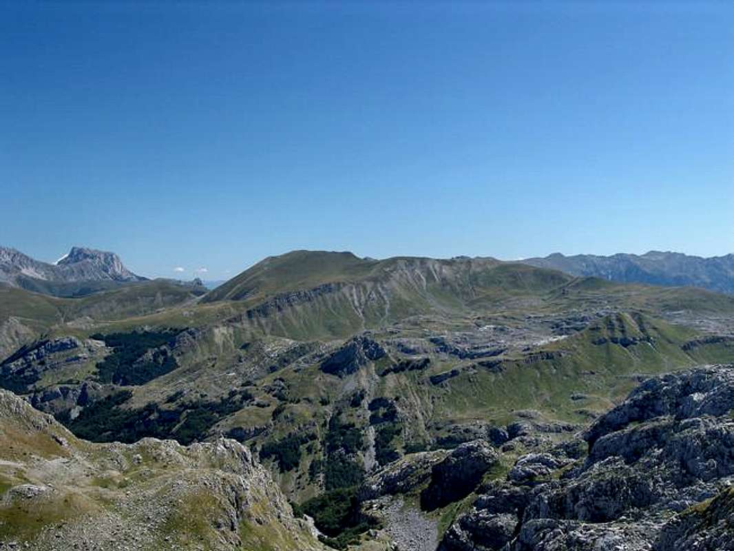
Maglič (Kučki) seen from the soutwest, from the mountain ridge of Surdup in Central cluster of Kučka krajina mountains
Camping
Like for the rest of Kucka krajina mountains GROUP, there are no mountain houses/huts or bivouacs in the area, also no camping places. Even in wider area you will not be able to find such objects at convenient distance.By state laws (like everywhere else in the world!) the camping is not allowed outside camping areas mostly because some would avoid to pay for prenotation, but this area is so remote and touristically undeveloped that many laws simply have no sense here. So hikers very often put up their tents by lakes in the area or close to the huts. There are no special rules on camping. No one can stop you from puting it up, especcially when you have no alternative to find another accomodation before night. But even if you camp on that "wild" way, BEHAVE ECO-CONSCIOUSLY!
Like on the most of other mountains in the area, here too you can try to ask local shepherds for a sleeping place in their huts in Katuns. They are modest people, they will never try to profit from you, not even ask money from you, so don’t take advantage of them. An offer to pay for accommodation, even to give some sweets to their children would be very nice and I strongly recommend it to you. And especially from June to early September, there will always be some people on many of those Katuns.
Other accommodation possibilities (if you plan a day hikes) are in Podgorica or Kolašin area, and Podgorica is much better choice because of larger number of hotels/motels, while Kolašin has only one hotel (another one was/was not to open) but very cheap – cheaper than a hostel in Europe.
North of Maglič in Komovi area locals are very ready and accustomed to accept hikers in their huts or around them (Katuns Carine – just south of Komovi is very convenient because of its vicinity from Maglič).
 |  |  |
Mountain Conditions
Nearest weather stations to the mountain are Kolašin, Podgorica and Medjuriječje (in Morača river canyon). Since Podgorica is in Zeta river valley it is very much open to Mediteranen influences and the weather in Podgorica is many times better and much milder than on Maglič. So Kolašin´s and Medjurječje´s weather reports and forecasts can be more usefull to you.Weather information at:
Kolasin at Accuweather
Kolasin at MultiMap-5 days Forecast
Pogorica at Accuweather
Medjurijecje at Accuweather
Other local weather info (sorry they don´t have English pages) at:
Meteo-CG
I was not able to find any live web-cam in the area to look at live weather situation.
Distances
Veruša to katun irokar Ljakovića (by road 12 km)Katun Širokar Ljakovića – Veliki Maglič (summit of Maglič) 1:30 h
Veliki Maglič (summit) – katun Mokro – downhill: 1 h
Katun Mokro-katun Bušat-Veliki Maglič: 2 h
 |  |  |  |  |
Maps
 |  |