
-
 51075 Hits
-
 86.26% Score
-
 22 Votes
|
|
Mountain/Rock |
|---|---|
|
|
42.99630°N / 17.15953°E |
|
|
3152 ft / 961 m |
|
|
Overview
Peljesac in Dalmatia (Croatia) is, after Istria, the second largest peninsula on the eastern Adriatic sea, and looking at its morphology it is in fact a long mountain – or even more precisely, it is almost 70 km long maritime chain of summits and hills that rises up to 961 m above the sea level. Sveti Ilija (Saint Elias) is the highest summit on Peljesac, situated on western part of the peninsula, above the coastal town of Orebic. Although 961 m does not sound very high, you should not forget the fact that many of climbs on Peljesac start from the sea level, so climbing 961 m of Sv. Ilija or any other summit on Peljesac means that you climb the absolute height of the mountain. Despite its lenght, the peninsula and its mountain ridge are just 3 to 9 kms wide, and from the summits of Peljesac you can get impression that youre climbing a mountain on some of the islands, without connection to the mainland. And Peljesac mountain ridge is just a long branch off the mainland Dinaric Alps, surronded by sea water (Neretva, Korcula;Mali Ston and Peljesac channels) from three sides and connected to mainland with only one narrow part (Stonska prevlaka 1,5 km wide), east of town of Ston.
The peninsula is mostly mountaineous and hilly, with well-indented and on many places steep coast, but also with some larger fields and many smaller ones, valleys and even canyons. Limestone prevails in hills and mountains and dolomites rock in valleys. Although the most of the terrain is carstic, very hard and harsh, unhospitable and without surface water, you will be able to find here many pictoresque beaches, very small islands, vineyards, olive trees and small rustical settlements. The peninsula has typical Mediterranean climate, with average year temperature from 15-18 °C. Some of the summits are already recognized as nice and interesting mountaineering destinations, thanks to the all year round accessibility and nice views.
Sveti Ilija (Saint Elias, 961 m) is the highest summit and the most famous mountaineering destination on Peljesac peninsula, situated on its western end. Massif around the summit of Sv. Ilija stretches from NE to SW coast of the peninsula, it is 6,5 km long and around 2,5 km wide. One legend says that the summit was called Perunovo brdo (Perun´s mountain) after old Slavic word for god Perun, the master of thunders. With the coming of Christianity the name of St. Elias replaced that of Perun. Later in history the Italian name Monte Vipera (Mountain of the snakes) was in use, also. Some think the name came after poisoned snakes (poskoks) that live in the area and the other think it is because of configuration of some steep rocky slopes above Orebic that resemble to snake, with their zig-zag lines of geological layers. Local people call it simply Ilija. On the summit od Sv. Ilija a small chapell dedicated to this saint used to stand, but was destroyed by many thunderstrucks. In lower areas of the mountain a mediterrainean oak and holm oak tree prevail. Above 750 m you can find nice forests of mediterranean pine tree (although some of the forests burnt in forest fires, recently). Other areas are covered with lower underbrush or are just rocky covered with fragrant mediterranean herbs. A view from the summit of Sv. Ilija in eastern direction  Ascents to Sv. Ilija last from 1:30 to 3 hours, depending on the location of your start.
Starting points are: ![]()
From hamlet of Urkunici (200 m east of Ruskovici hamlet, partially marked route – „classical ascent“, the shortest one but somewhat neglected) ![]()
From hamlet Gurici (800 m north of Franciscan monastery) ![]()
From hamlet Bilopolje (around 1 km west of Franciscan monastery, partially marked) ![]() From village Zukovac (500 m north of Zamosce by the Sea, old route)
From village Zukovac (500 m north of Zamosce by the Sea, old route) ![]() From St. Luke´s church (500 m NW of Kuciste, old route)
From St. Luke´s church (500 m NW of Kuciste, old route) ![]()
From Dol hamlet (500 m north of Viganj, old route) ![]()
From Gornje Nakovane (6 km NW of Viganj, marked route). The panorama from Sv. Ilija includes a view of mountains Biokovo, Mosor, Rilic, Cvrsnica, Prenj, Velez, delta of Neretva river, islands of central and southern Dalmatia (Korcula, Brac, Hvar, Vis, Mljet, etc..), all the way to Dubrovnik and Orjen mountain in Montenegro.
From Sv. Ilija summit and massif, in eastern direction along the peninsula, two lines of limestone mountain ridges stretch with wide valley Zupa between them. Further to the east we come to the lowest and the narrowest part of Peljesac around village of Janjina and still further in direction of Ston, between settlements of Zuljana and Prapratna run three paralell limestone mountain ridges with two carstic valleys Crna Gora and Ponikve among them.
 |
 |
 |
 |
 |
Getting There
Peljesac peninsula is situated in Southern Dalmatia, so the traffic-hubs most of the people use to reach the peninsula are Split or Dubrovnik. Since Orebic (as a largest town on Peljesac) does not always have direct or appropriate traffic-connections, many times you should consider nearby Korcula as your destination point, because the town of Korcula on the island of Korcula has good (especcially maritime) connections, and is very good connected to Orebic by a short ferry drive, too.
1. Getting there by air International airports in the area are Dubrovnik with best connections worldwide, and Split. Another possibility may include Mostar in Bosnia&Herzegovina, but with much less possibilities for transfer to Peljesac. If you wish to continue your travel, both cities, Dubrovnik and Split are linked with daily boat (via Korcula) and bus lines to Peljesac.
2. Getting there by bus Bus departure from Dubrovnik to Orebic and Ston (on Peljesac) more times a day, and you should bear in mind also that all buses from Dubrovnik to the island of Korcula (town Korcula and Vela luka) pass through Peljesac. Information on departures from Dubrovnik (in englisgh at: Dubrovnik Bus Station departures. If you plan to travel by bus from Split, the best is to take a ride to Ston station (on Split-Dubrovnik bus line) and then transfer to local buses. Also if you take off (from Split-Dubrovnik line) in Ploce you can cross Neretvanski channell by ferry boat to Trpanj on Peljesac. There is also one bus connection a day from Zagreb to Orebic (it will take you 12-13 hours). Info at Zagreb Bus Station schedules.
3. Getting there by boat The town of Korcula is just 30 min away from Orebic, by frequent ferry rides accros the Peljesac channel, but it has good passenger-boat connections (better than Orebic) to Dubrovnik and Split (daily coastal line starting from Rijeka, going to Split further to Hvar, Korcula and to Dubrovnik. In Split you can also transfer to/from ferryboats to Ancona in Italy). Orebic and Viganj on Peljesac are connected to the town of Korcula by passenger boat too. The village of Trpanj (northern coast of Peljesac) is connected by ferry boat 5-7 times a day with Ploce port on the mainland (1,15 h drive). More information on boat and ferry schedules at: Jadrolinija Boat Company. A view of northern slopes of Sveti Ilija from Ploce-Trpanj ferry 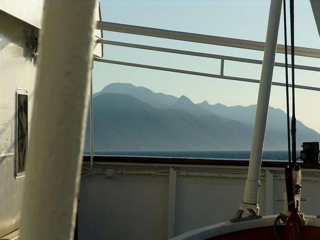
4. Getting there by train The nearest train station is in Split – and it is not so close to Peljesac. So after arriving to Split you should catch a bus (by coastal road, via Makarska) or boat (via korcula Island) connection to Peljesac. Split is connected to European railway network over Zagreb (cca 6 hours drive) Information on schedules for trains from Zagreb to Split at Zagreb Railway Station. (For Zagreb departure choose “Zagreb Gl.kol.”– Zagreb Main Station) - on this site also all lines and schedules in Croatia.
5. Getting there by car If you want to get to Peljesac by car you can choose two options – the first one to include car+ferry combination and the second one to drive a car all the way. From Split direction (if you are arriving from north, from Zagreb, and Rijeka directions): You should drive along the Adriatic coastal road (D-2, State Road No.2) from Split in direction of Makarska. After you pass Makarska and Ploce you will enter the territory of Bosnia&Herzegovina where the town of Neum is located. You should not forget your passport if you are coming from the state that need this document to enter B&H. After you drive 15 km through Bosnia Herzegovina you enter Croatia again and after 10 km you take off the main road to turn right to the town of Town, already on Peljesac peninsula (from Split to Ston there are 174 km). If you want to continue to Orebic you should drive for another 66 km along Peljesac peninsula to get there. You can also stop your drive in the town of Ploce and take a ferry Ploce-Trpanj that will take you to Trpanj on Peljesac peninsula in 1,15 h, therefore shorten your drive and gasoline.
From Dubrovnik direction (and Montenegro direction). From Dubrovnik take to Adriatic coastal road in Split direction, you pass Trsteno and Solin and after 45 km you take off the main road by turning left to Ston.
From Bosnia and Herzegovina direction (Sarajevo-Mostar) This is the road that follows Neretva river valley. From Mostar take the road to Metkovic and Ploce or simply follow signs for Dubrovnik. After you enter Croatia, in the town of Opuzen, turn left in direction of Dubrovnik. After 36 km (and passing Neum in Bosnia&Herzegovina) you arrive to branch off road for Ston and Peljesac. Info on road conditions in Croatia and other tourist info at: HAK – Croatian Automobile Club – info in English
 |
Red Tape
No special fees or permissions needed. Of the dangers in the mountains on Peljesac, you should give special attention to possibility to meet a snake, including the most poisoneous one in the area, locally called poskok. A view from the summit of Sveti Ilija in southern direction toward Peljesac channel and the island of korcula 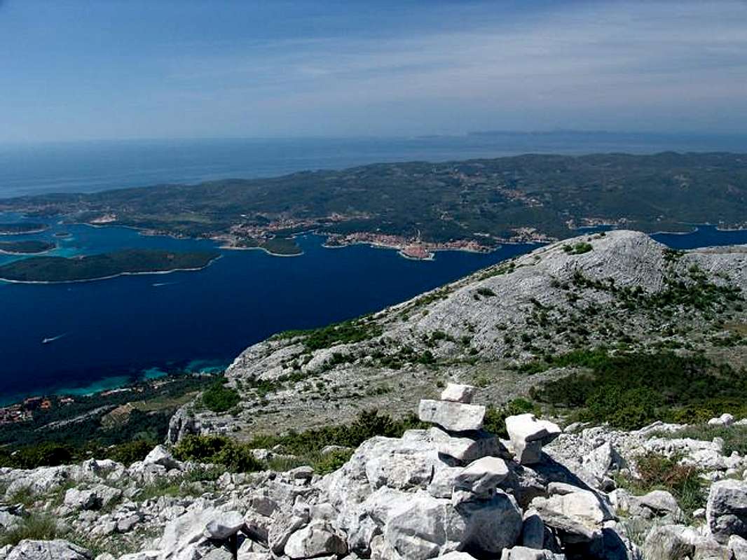
When To Climb
Mountains and heights on Peljesac peninsula are accessible to climb all the year round. Considering the fact that the whole area (including mountains and heights) belongs to the Mediterranean climate and the places in the area are some of the warmest in the Adriatic region thanks to the many sunny days, summer climbs can be the most unpleasant ones. You should avoid summer peak-temeperatures by climbing as early as possible. And the visibility can be much better early in the morning. Also the approaches to many of the summits are positioned on southern, therefore very insolated locations. Therefore, the best periods for climb are spring and fall, thanks to the more pleasant temperatures and nice visibility. Although the thin layer of snow can cover the summits on Peljesac for shorter periods in winter, generally the mountains and height are most of the times snowless and are accessible even during winter time. And winter climbs with excellent views on snow covered Dinaric Alps on the mainland and islands of the Adriatic can be very nice experience. The most dangerous weather situations on the mountains can be in case of sudden storm, a blizzard or a thick fog (especcially in late fall, early spring, or during sudden summer storms with lightnings).
 |
 |
 |
 |
 |
Camping
There are no mountain houses in the area. There are two hunters´ huts only, west of the summit of Sv. Ilija, but they are not open to wider public most of the times, or are available with previous arrangements. Nevertheless, you will have no problem in finding accomodation (camps, rooms, or hotels) of more commercial type in surrounding towns and villages on Peljesac (in coastal settlements mostly) For more information try at The Tourist Board of the Town of Orebic, or Peljesac Tourist Info.
 |
 |
 |
 |
 |
Mountain Conditions
Unfortunately, standard weather information sources for Croatia (DHMS – The Croatian State Hydrometeorological Institute) will not give you weather conditions for Orebic (which is bellow the main summit), nor for any other place on Peljesac. Therefore you should check the conditions for the nearest official meteo-stations in wider area, and check for the conditions in Central and South Dalmatia , and this can be helpfull too. Therefore you could check among forecasts for areas of Ploce, Makarska, Dubrovnik, island of Korcula or island of Hvar. You can obtain this general weather info at: DHMZ-Weather-english page DHMZ-forecasts in English DHMZ-local measuring points Maybe the best actual info on weather in Korcula-Orebic area can be found at an experimental meteo station with web-connection at Korcula Weather Station. You can also check actual weather conditions in the area at Korcula Web Cam, with a view to Sv. Ilija in the background.
Distances
![]() Orebic (the sea level, the Port / Parish church) –Ruskovici hamlet - The summit of Sv. Ilija (961 m): 2 to 2,30 h, marked path
Orebic (the sea level, the Port / Parish church) –Ruskovici hamlet - The summit of Sv. Ilija (961 m): 2 to 2,30 h, marked path ![]() Orebic – Karmen hamlet (170 m) – The summit of Sv. Ilija: 2 to 2,30 h, non-marked path
Orebic – Karmen hamlet (170 m) – The summit of Sv. Ilija: 2 to 2,30 h, non-marked path ![]() Orebic – Viganj village: by car, 7 km
Orebic – Viganj village: by car, 7 km ![]() Viganj – Gornja Nakovana: by car, 6 km
Viganj – Gornja Nakovana: by car, 6 km ![]() Gornja Nakovana – the summit of Sv. Ilija: 2 h, marked path
Gornja Nakovana – the summit of Sv. Ilija: 2 h, marked path ![]() Zuljana (or Zuljane, the sea level) – SE approach via Putnikovici village – Sv. Ivan (501 m): 1,30 h, marked path
Zuljana (or Zuljane, the sea level) – SE approach via Putnikovici village – Sv. Ivan (501 m): 1,30 h, marked path ![]() Zuljane – W approach – Sv.Ivan (501 m): 1,30 h, marked path
Zuljane – W approach – Sv.Ivan (501 m): 1,30 h, marked path
Maps
A map of Peljesac peninsula, showing relief and main summits 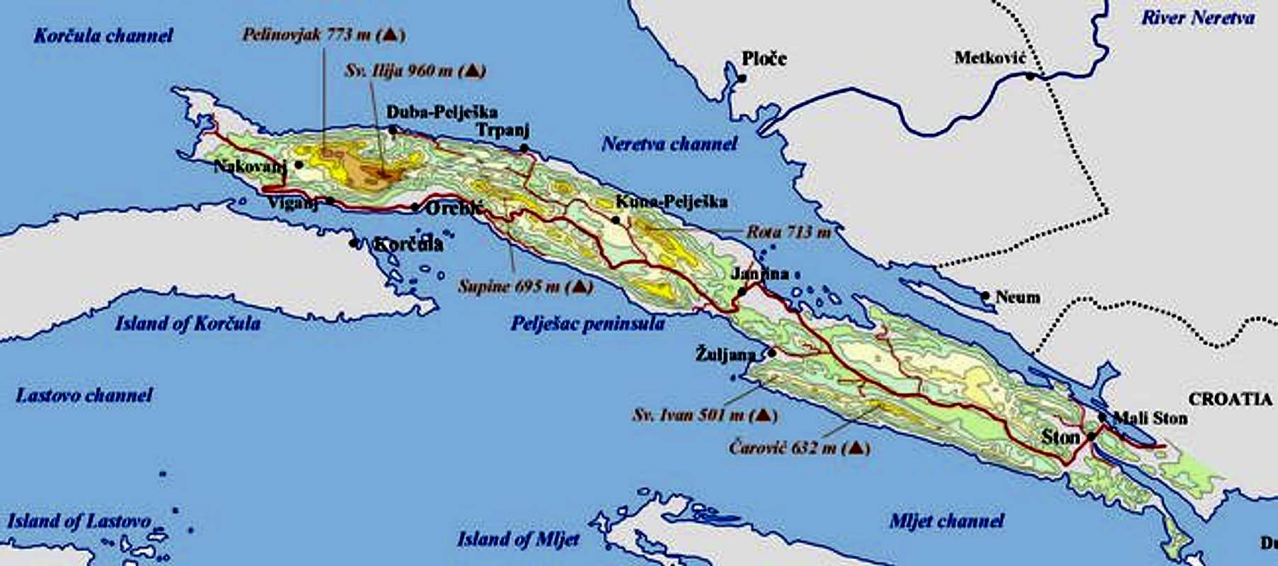
 |
pavlakovics - May 10, 2006 8:44 am - Voted 10/10
Marked pathsRoute from monastery through Bilopolje is well marked (we checked it personnaly), as well as route from Gornje Nakovane (third-party report); marks on Ruskovici route are very neglected and partly destroyed in forest fire; if someone is coming here for first time, I would recommend the Bilopolje route to avoid orientation problems; this route is also partly going through forest (shadow!)
Dinaric-ZG - May 10, 2006 11:15 am - Hasn't voted
...You are absolutely right! Although I have named the route over Ruskovici as the "classical", since it is the oldest and in older times also the most popular climb (and to me personally the most beatifull, because of nice scenery), these days this route is very much neglected an people tend to climb over Gornje Nakovane more and more because it is the easiest way, and it is the route also pilgrims use to climb the peak during religious festivities. I´ll try to reshape the text on SP page so there will be less problems in future. Thanks again. Take care, gord
jellyfishtong - Aug 4, 2014 9:48 pm - Hasn't voted
Help!Hi, i know it's been a while since you both posted about this trip, but I was wondering if this is a hike that's safe to do alone or if you knew about a group tour/hike that i could join? Additionally, how many days would you suggest staying in Orebic? I will be traveling from Dubrovnik and would like to head to Split after. I am a 27 yr old female traveling alone end of September. Thank you!