
-
 144821 Hits
-
 97.71% Score
-
 72 Votes
|
|
Mountain/Rock |
|---|---|
|
|
48.46770°N / 121.0592°W |
|
|
Skagit, Chelan, Snohomish |
|
|
Mountaineering |
|
|
Summer |
|
|
7800 ft / 2377 m |
|
|
Improved Maps!
As of October 28, 2008, this page now links to maps on www.mapper.acme.com. Clicking a map link in the tables below now opens up a new window or tab, leaving this page open to refer back and forth. ACME maps work like the Google maps on which they are based, with some important differences: 1. They fill your entire browser window; 2. They give the option of genuine USGS maps, not just Google's terrain approximation; 3. They offer two satellite views: the color one we're familiar with and "DOQ", a black-and-white image that in the Ptarmigan gives much higher resolution.
Overview
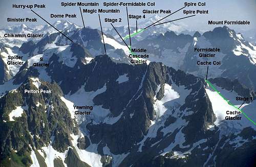 Photo and annotations by rfbolton.
The Ptarmigan Traverse is perhaps unique in Washington: a week-long, off-trail high route weaving between the glaciated peaks of the North Cascades, never straying far from the crest. This is not the Pacific Crest Trail; that's miles away to the East. The Ptarmigan is not for hikers, so much as for climbers, and experienced ones at that. Essentially a mini-expedition, it requires off-trail wilderness navigation, extensive glacier travel, self-reliance, and commitment. The rewards are the views, the climbs of peaks so remote that this traverse is their most common approach, and the adventure of it all.
The traverse is usually completed in about a week, most commonly in July or August, and usually done from north to south. How and when you accomplish it is entirely up to you and your partners. Race through it in three days or take two weeks to climb every nearby peak and swim in every frigid lake. It's even been skied in a single day. There's no rule against starting from the south, or exiting down a side valley. We'll point out those exits along with the peaks along the way, and why most parties prefer to do the traverse more-or-less as we describe it here.
Though the PT is obviously a route, calling it a mountain allowed me to attach routes to it. Taking advantage of SummitPost's structure, I've divided the traverse into stages, each stage being a day's travel for the average party. Each stage is treated like a route on other SP pages; access them by clicking the links under the Routes heading in the left sidebar, or in the table below.
The stages, as I've divided them, run from N to S:
|
Stage (links to route description) |
From – To (links to ACME map of start) |
|
Cascade River to Kool-Aid Lake |
|
|
Kool-Aid Lake to Yang Yang Lakes |
|
|
Yang Yang Lakes to White Rock Lakes |
|
|
White Rock Lakes to Cub Lake |
|
|
Cub Lake to Suiattle River Road |
Climbers on the Ptarmigan find themselves choosing from these summits:
| Name | Elevation | ACME Map |
|
7440 |
||
|
Magic Mountain |
7610 |
|
|
Hurry-up Peak (S Mountain) |
7800 |
|
|
8286 |
||
|
8325 |
||
|
Le Conte Mountain |
7762 |
|
|
8240 |
||
|
Sentinel Peak |
8261 |
|
|
Lizard Mountain |
7400 |
|
|
Spire Point |
8264 |
|
|
8920 |
||
|
Sinister Peak |
8440 |
|
|
Gunsight Peak (Blue Mtn.) |
8198 |
Dome, Sinister, and Gunsight are beyond the S end of the PT, but are so tempting they're often climbed as part of a Ptarmigan trip. Ragu tells me that the original 1938 party also climbed Sahale, Buckner, and Johannesburg. Look at the map and be humbled.
Only a few of the peaks along the way have SP pages yet. I hope this will spur SP members to add more. Beckey's guidebook lists dozens of lesser peaks and spires along the way, named and unnamed.
Getting There
Northern start: Drive the North Cascades Highway (State Route 20) to the town of Marblemount – your last chance for gas, food, anything. Where the highway makes a sharp right-angle bend, turn off on the Cascade River Road, immediately crossing the Skagit River on a steel bridge. (If you're driving up SR 20 from the west, you'll just go straight where the highway turns sharply left.) Follow the Cascade River Road 22 miles to the dead-end at a large parking lot for the Cascade Pass trailhead, elevation 3,660 feet. The road starts paved, then good gravel. The last few miles are fairly steep. It sometimes washes out a mile short of the end. The National Park lists road conditions here. The Ptarmigan Traverse begins by hiking the Cascade Pass Trail. See the Stage 1: Cascade River to Kool-Aid Lake route page.
Southern Start: From Rockport on State Route 20 (You just got your permit in Marblemount, right?) drive S up the Sauk Valley road about 10 miles to the Suiattle (pronounced like Seattle, but with an “ooh” sound between the S and the E) River road and turn left. OR, if you're coming up I-5 from the South, take the Arlington exit and drive SR 530 E to Darrington, then take the Sauk Valley road about 9 miles N to the same Suiattle River road. Drive the Suiattle road 19.5 miles to the Downey Creek trailhead, 1,450 feet elev. (Summer 2010 update: Winter storms have washed out sections of the Suittale River road. Plan on hiking about nine miles of road between the lowest washout and the Downey Creek trail.) Hike the trail about 6 miles to 6-Mile Camp. Continue another ½ mile to the intersection with Bachelor Creek trail, 2,400', and turn right. More details in the Stage 5 “route” section.
For a broad view of where in Washington State we're looking, the entire Ptarmigan Traverse, including approach trails, is between the 'A' and 'B' markers on this map. Drag the map so either marker is under the center crosshairs, zoom in and click the TOPO box at top-right for all the detail of a USGS map.
|
|
|
|
|
|


Red Tape
Parking: Every entrance or exit point where you might park a car is on either National Forest or National Park land. The Cascade Pass Trail (N start) is in the National Park, where no pass is required to park. You'll need a Northwest Forest Pass ($30/year or $5/day) displayed on your car to park at the south terminus or any of the side trails that are on National Forest land. Info about purchasing passes (locally, by mail, or online) can be found here: National Forest
2011 update: The Suiattle River road is washed out, requiring a 9-mile road walk between the normal Downey Creek trailhead and your car. Because you can't use the trailhead parking, the Forest Service does not require a parking permit at this time. (Thanks to Norman for this update and the one below.)
Camping: Nearly all of the Ptarmigan is in protected Wilderness of either the North Cascades National Park or Mount Baker-Snoqualmie National Forest or Wenatchee National Forest. Part of that protection is a limit of six people per party. Your party will need a Backcountry Permit to stay overnight along the traverse. The permit is free, but you must get it in person on the day you start or the day before. Be prepared to tell where you intend to camp each night. (The only officials you might meet on the traverse will be National Park climbing rangers. They understand you may have to bend your schedule around the weather or other conditions.) Pick up your permit at the Wilderness Information Center in Marblemount. (Watch for the brown sign that directs you N one mile up Ranger Station Road. It leaves the highway 0.9 mi. W of that right-angle bend where the Cascade River road branches off.) Scroll to the bottom of this page for hours, season, phone numbers, etc. Apparently Marblemount is the only place accessible by road where you can obtain your Backcountry Permit in the summer, even if you're starting from the South. (The one other place listed in the National Park website is the Purple Point Ranger Station at Stehekin (“ste-HEE-kin”), on the NW end of Lake Chelan (“sheh-LAN”). Getting to Stehekin is in itself an adventure, requiring a boat ride up the 52-mile-long lake or a long hike over the mountains on any of several trails.)
The National Park and Mount baker district of Mount Baker-Snoqualmie NF are so intertwined they share a headquarters building in Sedro Woolley and operate a joint website, besides those listed above. It offers some entertaining reading if you're serious about the PT. Also check out this Backcountry Trip Planner from NCNP.
2011 Update: Camping in not allowed at or near Cascade Pass, and when you cross through Cache Col toward Kool-Aid Lake, you pass out of the National Park and into Glacier Peak Wilderness Area. The wilderness area covers parts of both Wenatchee and Mount Baker-Snoqualmie National forests. The websites for both forests do not mention permits being required to camp in Glacier Peak Wilderness. They request that you sign out at any trail register you find at the trailhead, to help track trail usage and possibly attempt to find you if you don't come out.
When To Climb
Mid-July through Mid-September is the usual season. Experienced backcountry/glacier skiers may enjoy trackless solitude in Spring.
Camping
There are only a few lakes along the PT; it just happens that they're about a day's hike apart. Most parties choose to camp at Kool-Aid Lake, then Yang Yang Lakes, then White Rock Lakes, and finally (maybe) Cub and Itswoot Lakes. At all backcountry lakes, including these, the Forest Service requires that you camp at least 100 feet from the water's edge. There are alternatives to these camps to allow for more time spent climbing, shorter or longer stages, or other situations. As mentioned under Red Tape, you need a Backcountry Permit to sleep in the wilderness. The traverse is almost entirely above treeline, and what plants you encounter are precious. Don't even think of building a campfire.
There are critters along the PT that want to eat your stuff. Black bears may be seen along the trails. Any you see in the high lonesome of the PT are probably truly wild, that is, not the garbage-raiding types that lurk around lowland campgrounds. They'll probably give you wide berth. Grizzlies and wolves are regaining a foothold in the Cascades, but are very seldom seen (I've never seen either.), as are the big cats – cougar, lynx, and bobcat. Mosquitoes are another matter entirely. A bottle of bug repellent may be your best friend, especially in early season and along the lower-elevation approach and exit trails. Deer can be a problem here. The soil in this section of the Cascades is so devoid of salt, they'll do anything for a taste of it. At our camp S of Spider-Formidable Col we were pestered by a group of 6 or seven bucks. They stole some of our gear to munch the straps for salt. It took some yelling, snowball-throwing, and running on steep snow, but I think we retrieved everything. [At another camp in the Entiat Valley, E of Glacier Peak, I was minding my own business, taking a pee, when a couple of deer came out of the bushes to eat the dirt where I pissed. Damn things wouldn't even wait for me to finish.] Marmots, like deer, are strict vegetarians. But don't trust them around sweaty nylon.
 |
 |
 |
 |
Mountain Conditions
The eastern half of Washington State is mostly a semi-desert plateau. It owes its dryness to the Cascades: moisture-laden winds off the Pacific can't climb over the Cascades without losing most of that moisture. Consequently, if you spend a week on this traverse, you'll probably get rained on -- unless you do it in the dead of winter. In July or August you might travel in shorts under clear skies, but come prepared for drenching rain, wind, fog, or snow flurries. In winter and early spring snow will add miles to the approach and exit, and avalanche conditions are unlikely to be favorable for more than a few rare days at a time.
Check for current road and trail conditions on these pages from NCNP, MB-SNF, and WNF.
Check the weather through the Seattle office of the National Weather Service. This point forecast is near the center of the PT.
Essential Gear
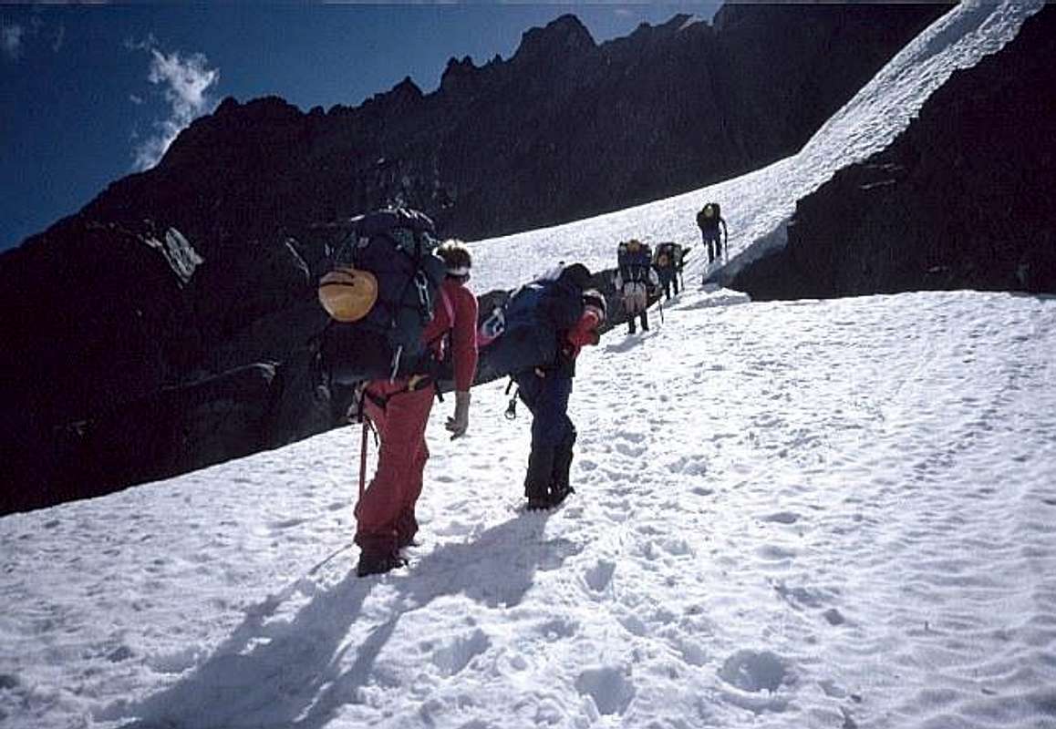 [Normally Essential gear is listed for individual routes, but since all these routes are stages of one trek, we can spell it out just once.] Mountaineering boots, crampons, gaiters, ice axe, harness, rope(s), prusik slings and pulleys for crevasse rescue, the maps listed below, a pencil (You may have to navigate on instruments; you'll want to mark your map.), a thinned-out rack of pro, the Ten Essentials, and everything you need to eat and camp for a week.
[Footnote: When I did it in mid-August of 91, I packed running shoes to wear around camp or on dry stretches to give my feet a break from stiff plastic boot. I never wore them. We were nearly always on snow, including at camps, or on terrain too uneven or slippery for shoes. When we finally reached the Suiattle River road at the end, we still had 6 miles of road to walk due to a washout, so I dug my shoes out of my pack to walk the road in comfort. My feet had been fine until then; in six miles of level road I got major blisters.]
Maps and Books
USGS 7.5' Quads Cascade Pass, Dome Peak, and Downey Mtn. cover the entire route. All three are essential to resolve any route-finding problems. Smaller-scale maps, such as the Green Trails series may not have the detail you need, especially if the weather turns sour. I like to also carry large-area, small-scale maps to help identify distant peaks or to facilitate an emergency exit down an alternate valley. For those situations, bring a North Cascades National Park Backcountry map (their tourist brochure maps are here.) and maps of Mount Baker-Snoqualmie National Forest and Wenatchee National Forest. All the applicable NF and NP maps can be purchased from this WNF page.
There are other climbing guidebooks that include some of the peaks along the PT, but the only comprehensive guide is Fred Beckey's Cascade Alpine Guide, Stevens Pass to Rainy Pass. Beckey's guide describes 2 or 3 times as many peaks (and little towers) as are named on the USGS maps, and includes perhaps the only guidebook decription of the PT itself, though it's buried in the “Trails and Alpine Hiking Approaches” section.
Why Do It from North to South?
You don't have to, but here are three arguments in favor:
-
From the Ranger Station in Marblemount, where you just got your permit, it's a straight shot east up the valley to the Cascade Pass trailhead. Going to the southern end means driving back west out of the mountains, south, and back in again.
-
You start hiking 2,220 feet higher.
-
Part of the Bachelor Creek trail, in the southern end, has been almost obliterated by slide alder, a dense forest of small, flexible trees that grow downhill, then swoop up, interlocking their trunks and branches. If they were rigid you could hug an occasional trunk and swing under it, but slide alder will simply bend and set you down on your back, feet uphill. It's probably a half-mile or less, but even going downhill with an almost-empty pack is hard work. Going uphill with a pack full of climbing gear and a week's food is... well, you get the idea.
What's a Ptarmigan?
The first party to explore the route (in 1938) was a group from the Portland, Oregon Ptarmigan Climbing Club. The club was named after a species of mountain grouse that molts twice a year, changing from a speckled granite-like pattern to pure white and back again. The P in ptarmigan is silent (TAR-mi-gan).
 |
 |
External Links
- Trip Report
Phil Fortier's Trip Report--Great Photos! - Michael Stanton and Theron Welch's trip
A great 6 day trip, climbed a few peaks along the way
Norman - Aug 10, 2011 9:46 am - Hasn't voted
PermitsWe did the Traverse from North to South. Once you cross Cache Col you leave the National Park. We checked at Marblemount Ranger about the permit. You are out of the Park, so no permit required by National Park from Kool Aid Lake to Suiattle Road. At this time the Suiattle Road is blocked because of the washout,so no parking permit is required there either. This was a permit free zone...except from our wives, but they tell us to take a hike anyway... Also, the road blocks 9 miles of easy walking from car to Downey Campground where the Downey Creek trail begins to Cub and Itswoot Lakes. There are milage signs every mile on the road. We did the road in 3 hours.
Eric Sandbo - Aug 12, 2011 1:40 pm - Hasn't voted
Re: PermitsThanks for the update. I'm down to doing easy stuff with my kids and appreciate any help in getting my SummitPost stuff to approach the truth.
scottk - Aug 12, 2011 1:08 am - Hasn't voted
Route from Yang YangWe followed the route description in Stage 3 out of Yang Yang Lakes and found it inaccurate. We ascending WNW to the ridge crest and found it vary difficult to "walk" the ridge crest south. There's a hump on the ridge (point 7004) that is very difficult to get around. We ended up descending and finding the "goat path" that ascends up the a rib that is southwest of the lakes. It's discussed in Beckey and you can see it from below. It's a relatively easy and direct route to the lowest spot on the ridge (about elevation 6,500 ft).
Eric Sandbo - Aug 12, 2011 1:49 pm - Hasn't voted
Re: Route from Yang YangI did ya wrong -- I'm sorry. My only defense is that it's been ages since I was there, and nobody else has pointed out the inaccuracy. That's the beauty of SP: anyone can help improve it. If you found anything else I messed up or that's changed, let us know. And hey - you just came back from one of the world's beautiful places - got any pics? Thanks.
Norman - Aug 18, 2011 2:25 pm - Hasn't voted
PT trip reportEric: No problem, we valued your stages reports very much. I should point out that the two other teams doing same basic trip as we did...we all had your stages printed out. My trip report is on your page with pics. You own a good page there...
gimpilator - Sep 18, 2016 10:56 am - Hasn't voted
Route PageThis is a good page and an important one for Washington State, however it is a route. I think we can all agree that it's a route. So why is it listed as a mountain/rock? This page ought to be listed as a route.
pcole8787 - Jul 10, 2018 6:35 am - Hasn't voted
Trip ReportsThe first one is interesting enough, the 2nd one no longer exists (404 error). A somewhat current TR in 2012 can be found at: http://myadventuresinthemountains.blogspot.com/2012/08/ptarmigan-traverse.html