
|
|
Mountain/Rock |
|---|---|
|
|
44.09470°N / 73.9503°W |
|
|
4606 ft / 1404 m |
|
|
Overview
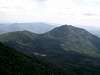
The fifteenth highest peak in the Adirondacks Redfield stands almost exactly in the center on the Adirondack Park. By the book, this peak is 1 foot shorter than Santanoni but Redfield's peak has a hulking great rock near the summit sign, which must put it well past Santanoi by at least 3 or 4 feet. However, I do not think the mountains nor the USGS care very much about this.
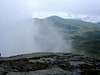
Though it is totally tree covered the peak has a very dramatic summit, which it is only about 150 meters long and about 30 wide. As a slight consolation the view from the top of the summit rock is very good toward the south.
The normal route starts from Uphill Lean-to and follows Uphill Brook (not the most original name in mountaineering circles) to a large waterfall (50 feet high and a great view from the top) one of many on the route, but by far the biggest. Continue to follow the stream up for about another 0.3 of a mile to where a tributary comes in from the R. Follow this tributary and then head strait to the summit.
 |  |  |
Getting There
As it sits in the center of the Park there are many ways to approach this peak including from the N and Adirondack Loj over the MacIntye Range (Algonquin), over Marcy to four corners and then down the Feldspar trail, over Colden, through Avalanche Pass, or up and over the Lake Arnold Pass.
From the E and the Gardens at Keen one can go directly up and over the entire Great Range then over Marcy to four corners and then down the Feldspar trail, or stay in John’s Brook valley and take the Phelp's trail to Marcy and over.
From the SE one can head in through the many trails in the Adirondack Mountain Reserve to Four Corners and then down Feldspar.
From the S one can head in from Elk Lake to Four Corners.
From the SW one can start at either the Lower or Upper Works to get to the Flowered Land and then onto the trail.
Normally this is an overnight trip starting at any one of the many camping areas near it. As a day trip it is one of the longer ones from any direction and it would require a very early start and no side trips to complete in a day.
Red Tape
The frist part of both the Upper and Lower Works trails, The Adirondack Mountian Reserve trails and the Elk Lake trail are on private land please observe these simple rules
1) No camping, fishing or hunting
2) No off-trail travel including rock climbing or bushwhacking, or use of non public trail
3) No boating or swimming, including portable boats brought by the public
4) NO DOGS or other pets are permitted unless on a leash
As of June 30th, 2001 all parties regardless of size in the Eastern Zone (High Peaks) of the Park must fill in and possess a self-issuing "trip ticket," which may be obtained at the trailhead. People have been fined and turned around for not having one and at the more popular trailheads the Ranger on duty will not let you pass without one. This can cause some delays in getting onto the trail.
When To Climb
If you like dry feet and hate waterfalls go at the end of summer.
However if you like waterfalls and do not mind wet feet go in early summer, late spring or early (September, iced over after that) fall.
Camping
Same as for all Adirondack mountians.
1) No Camping above 4,000 feet
2) No camping withing 150 feet of a stream or other water source except at a designated campsite.
3) No soap or washing withing 150 feet of water
4) Pack it in Pack it out is the rule for garbage
5) Only dead and down wood can be used for fires and set in a proper fire pit. ( local etiquette is to use a stove and not a fire)
Mountain Conditions
some good links
ADk 46ers
Adirondack Hiking Portal
What's In a Name
The peak is named for Professor William C. Redfield, meteorologist, organizer of the first expedition to Marcy and one of the party during the first recorded ascent of Marcy in 1837.
Redfield should also be noted as the first one to guess that Marcy was the highest peak in the Adirondacks. He called it the "High Point of Essex" and therefore New York during a reconnaissance up the Opalescent River some time before the first assent in 1837.
He based this on some rough calculations he made from Lake Colden and because of this the 1837 survey made for Marcy rather than Algonquin first.
Verplanck Covin suggested the name when compiling the data from his 1876 survey.
WhiteLief - Feb 20, 2004 9:39 am - Hasn't voted
Untitled CommentFrom the Uphill Brook Lean-To, the herd trail is marked with colored flags. The route travels on the south side of Uphill Brook. The flagging ends part way up, and the route travels in the strem bed for a while. Where the brook forks, take the right hand fork, and follow in or along the brook towards the ridge. Near or at the ridge, the summit is south (to the right).
This route was the one we climbed in February '04, following a nicely packed snowshoe trail. I believe the more traditional route is a little more northerly, staying in the stream bed, heading towards Moss Pond at the ridge before turning south.
A great deal of trail maintenance has removed many of the obstacles from Hurricane Floyd blowdown.
ADKhiker46 - Apr 11, 2004 7:46 pm - Hasn't voted
Untitled CommentI was just in the area this past weekend, climbing Redfield and Cliff. If you are on the trail toward the Opalescent Lean-to, (trail 121 on adk map) you can't miss the trails. You will see the lean-to to your left while on trail 121, almost directly to your right is the trail up Cliff and another 10-15 yards straight ahead is the start of Redfield. This path has MANY flags on the trees and it is very obvious where the path goes. The Cliff start does not have any flags but it does have 3-4 on trees in route to the summit. Both have fairly well packed routes to the summits; should be no problem getting to the top. (Snowshoes still VERY useful) (Also, if you cross Opalescent you've gone too far)
northflow - Sep 18, 2005 1:45 pm - Hasn't voted
Untitled CommentThe "some time before the first assent in 1837" occurred on August 19, 1836. The mountain was named by Colvin in his first report of the Topological Survey of the Adirondacks (at page 41) which was published in 1873 and discussed the first year's survey work during 1872. He also named Street and Adams on the same page.
ScAtTeRbOnE - Jun 24, 2012 10:36 pm - Hasn't voted
RulesNo dogs at all on AMR property and no campfires at all in the Eastern High Peaks Wilderness.
Bark Eater - May 25, 2015 3:37 pm - Hasn't voted
Route clarificationThe route starts at the large cairn on the marked trail, very close to the Uphill Leanto. After a few minutes it reaches a second cairn. Left fork climbs Redfield, generally as described above. The route is in and out of the stream bed several times. Look for small cairns marking the way. Right fork climbs Cliff.