
-
 11290 Hits
-
 83.69% Score
-
 17 Votes
|
|
Mountain/Rock |
|---|---|
|
|
42.01600°N / 123.102°W |
|
|
Hiking |
|
|
Spring, Summer, Fall, Winter |
|
|
4400 ft / 1341 m |
|
|
Overview
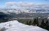
Stein Butte is located in the extreme southwest corner of Jackson County, Oregon on the Elliott Creek Ridge. Elliott Creek Ridge begins at Applegate Lake, proceeds easterly to Stein Butte, and then beyond for many miles to Lily Mountain. The Oregon/California border is only ½ mile directly south of the summit. Stein Butte is located in the Siskiyou Mountains, the home of the Applegate Ranger District. From the summit of Stein Butte there are great views of the Siskiyous and Applegate Lake.Just south of the ridge that includes Stein Butte is a taller ridge that includes the Red Buttes Wilderness area and the Pacific Crest Trail (PCT). Separating these two ridges is the Elliott Creek drainage. This section of the PCT runs in an easterly direction from the Red Buttes, past Mt. Ashland, and crosses I-5 before heading north again.
The Siskiyou Mountains are unusual because they run east and west to form a bridge connecting the Coast Range and the Cascade Mountains. This connection allows plant species from these different regions to meet and intermix.
 |  |  |  |  |
Getting There
Option1: To find the trailhead from Interstate 5 in Medford take either the North or South exit from I-5 and follow the signs to Jacksonville and Hwy 238. Jacksonville is a quaint historical town located about 6 miles west of Medford. The whole town of Jacksonville is on the National Historic Register because of its well preserved buildings from the 1850’s when gold was discovered nearby. After driving through the middle of Jacksonville continue on Hwy 238 towards Grants Pass. About 8.6 miles from Jacksonville is the little settlement of Ruch. Applegate Road is the major intersection here. Turn left or south onto Applegate Road and head towards Applegate Lake.Applegate Lake is 15 miles along Applegate Road and the Applegate River. On the way you will pass the Star Ranger Station and McKee Bridge. McKee Bridge is a little settlement that is famous for its covered bridge across the Applegate River. Once you get to the Applegate Dam stay to the right and follow the road down the west side of the lake for another 3 miles to the end of the lake. You come to a “Tee” intersection and you should turn left to continue following Applegate Road.
In another mile, you cross over a bridge and come to Seattle Bar on your right and Road 1041 on your left. Turn left and park in the raised area on the left about 100ft from the intersection. Seattle Bar is a nice picnic area where you could also park. There is a trail from Seattle Bar that follows the river under the bridge and then up to the trailhead near where you park on Road 1041. The trailhead is another 100ft down the road on the right. There is a big sign that says “Stein Butte Trail”. The trail has been numbered by the forest service as number 929.
There are at least two other trails that access Stein Butte.
Option2: Option 2 is trail number 928 also known as the New London Trail. To find this trailhead, follow the directions to Seattle Bar in Option 1. Instead of stopping at Seattle Bar, continue on the main road. Within about ¼ mile the pavement ends and a good gravel road continues. The pavement ends at the California/Oregon border. In another couple of hundred yards there is a big intersection. Stay to the right and follow road 1050 up Elliott Creek. Pass the turn off for Cook and Green Trailhead. Pass through a little residential area with several old houses and outbuildings. At 3 miles from Seattle Bar, you arrive at the trailhead. There is a big parking area off to the right of the road and the trail starts on the left.
Option3: Is accessed from the Squaw Lakes to the east and hiking westerly on the ridgetop trail along Elliott Creek Ridge
Red Tape
No permits required unless you want a campfire. The infamous Northwest Forest Pass needed for parking at most trailheads is no longer required at any trailhead in the Rogue River or Siskiyou National Forests.Ranger Station Info
Applegate Ranger District
Erin Connelly, District Ranger
6941 Upper Applegate Road
Jacksonville, Oregon 97530-9314
Voice: (541) 899-3800 FAX: (541) 899-3888
When To Climb
This mountain is accessible year round.Winter snow rarely accumulates to more than 6 inches in the winter.
Summer hiking could be quite hot. The mountain is not tall enough to get above the 100 degree plus temperatures in the valley. This would be a good morning hike and then cool off in the lake in the afternoon.
Other trails in the area
Camping
There are lots of camping areas within a few miles of the trailhead, including areas around Applegate Lake. Some of these campgrounds are closed in the winter, so call ahead to find out about access.There really is no backpack camping available along the trail. You could make a bivy site once you get up to the ridge line or at the summit if you wish.
Follow these links for more camping information.
Forest Service Camping Info
Mountain Conditions
This mountain is accessible in the winter and that is the primary reason that I keep coming back and climbing it. I have climbed it a couple of times after snow storms, but the snow rarely accumulates to more than 6 inches in the winter.Summer hiking could be quite hot. The mountain is not tall enough to get above the 100 degree plus temperatures in the valley. This would be a good morning hike and then cool off in the lake in the afternoon.
For current weather conditions in Medford follow this link
Weather Conditions