


-
 39381 Hits
-
 97.19% Score
-
 66 Votes
|
|
Mountain/Rock |
|---|---|
|
|
45.91750°N / 7.02500°E |
|
|
Aosta - Haute Savoie, France/Italy, Europe |
|
|
Mountaineering |
|
|
12696 ft / 3870 m |
|
|
Overview
 East Side of Aiguille de Triolet - Photo by andrea.it
 |
 | 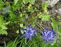 |  |  |  |
| Gentiana - Purple Gentian | Phyteuma - Rapunzel | Geranium | Geum Montanum | Sedum - Stonecrop, Val Ferret |
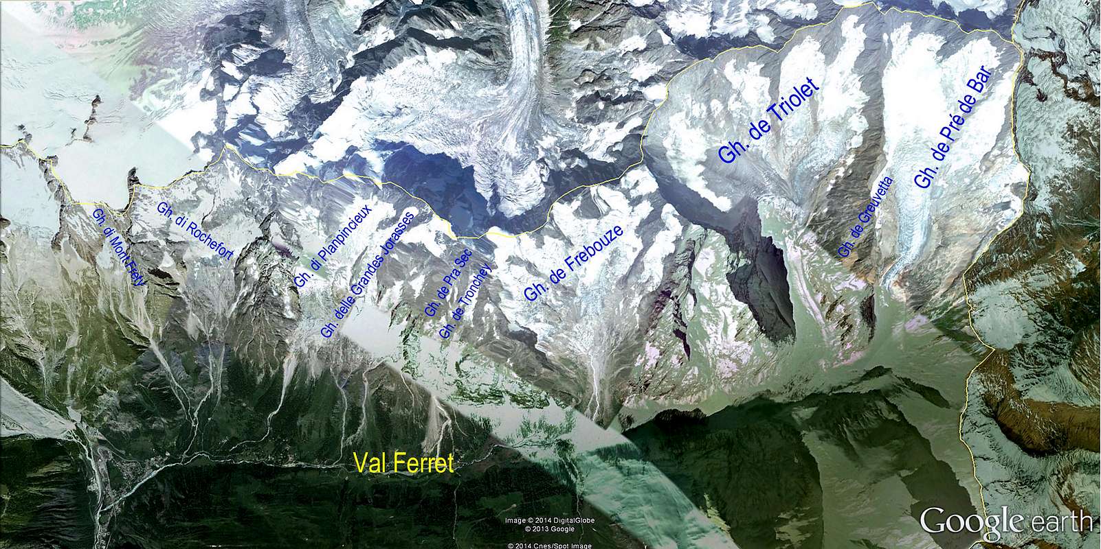
- The Aiguille de Triolet belongs to the Mont Blanc massif. It's placed in the eastern part of it, and also it's point of union of 4 ridges that divide as many basins.
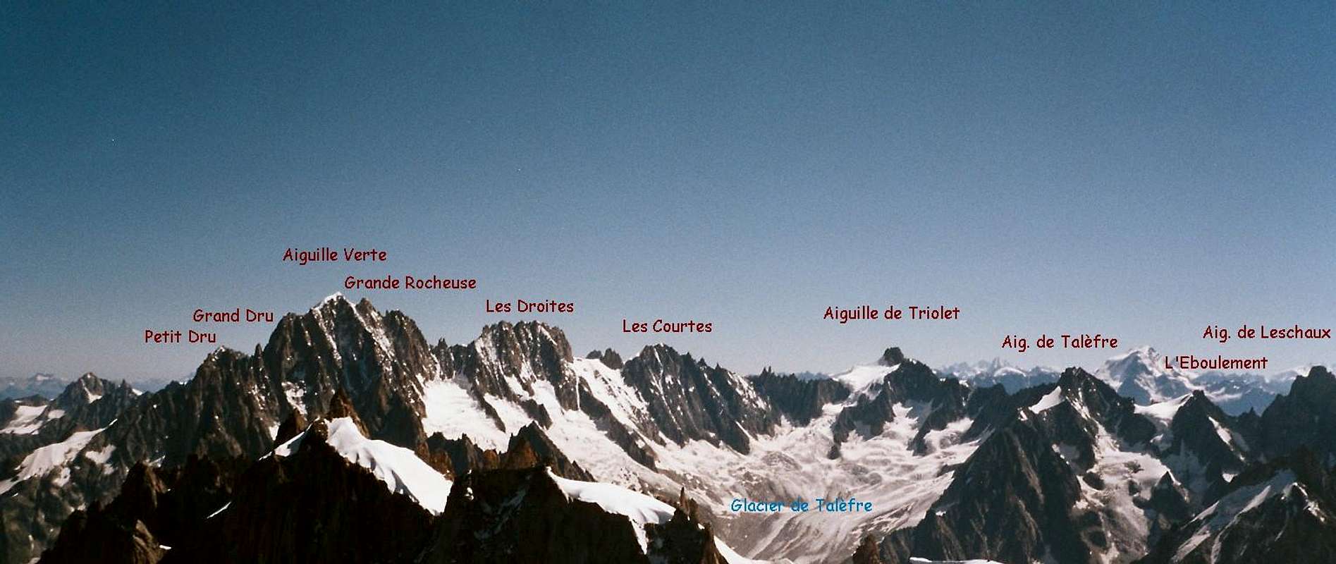
On the north side (France), from the summit starts a ridge that includes the famous Les Courtes, Les Droites,Aiguille Verte and divides the basins Argentière (north) and Talèfre (west) with their ominous glaciers.
On the south side (Italy), a minor ridge called Mont rouge de Triolet, divides the basins Pré de Bar (east) and Triolet (south). Both covered by glaciers, but smaller if compared with the northern neighbours.
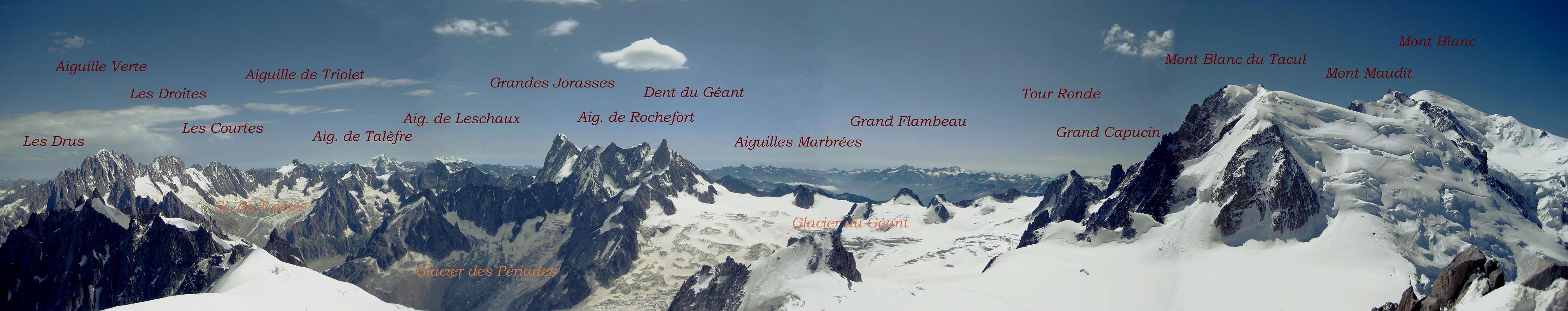
The boundary ridge between Italy and France where the Aiguille de Triolet is placed, includes also important summits (from east to west) as Mont Dolent, Aiguille de Talèfre, Aiguille de Leschaux and Grandes Jorasses.
The west flank is almost totally covered of ice and it's also easily climbed by ski. The other 3 flanks are made of good yellowish granite, first of all the spectacular north wall above the Argentière Glacier, which has made this mountain famous in the alpinism history.
- The first climbers of the Aiguille de Triolet were J. A. G. Marshall, U. Almer and J. Fischer on 26. August 1874.
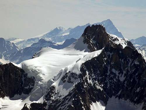 Aiguille de Triolet - 3870 m - Photo by Antonio Giani Aiguille de Triolet - 3870 m - Photo by Antonio Giani |
- During a long time, the classic north face route of 1931 was important. It has been considered as the most difficult ice climb in the Alps.
Even today, it's a route where ice climbers can increase their reputation. The other routes are seldom climbed. This classic route from 1931 was done by R. Gréloz and A. Rochs, technically very gifted climbers from Geneva.
At that time, the main problem of the face was the ice conditions; this is a problem which has lessened over the years from the first ascent.
Of course, on any snow and ice route, success always depends on the quality of the snow; nevertheless, these days, with the technical advances made possible by front-point crampons and by ice pitons and screws which allow good belays and abseils (both of which were impossible earlier on), it is possible to undertake this climb even if optimum conditions do not prevail everywhere on the face.
It is this, as well as the face's intrinsic beauty, which explains why there are a number of ascents every year.
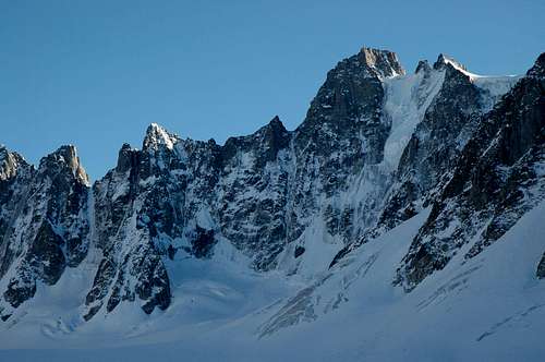 North Side of Aiguille de Triolet - Photo by Jeroen Vels North Side of Aiguille de Triolet - Photo by Jeroen Vels |
- As is the case for any glacier face, the north face of the Triolet changes year by year. The snow, annually accumulating above and slowly compressed to form ice, moves downwards, adds weight to and extends the rows of seracs.
The slope is very steep, 53° at the bottom and even steeper in the middle. The angle towards the top depends on the route taken; you can go straight up as did A.Contamine and L.Lachenal, but normally you traverse right above the big serrac barrier and then either come back left to get to the summit or exit directly onto the ridge of the Petites Aiguilles du Triolet.
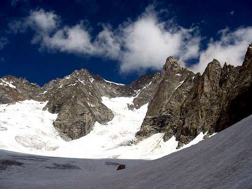 South Side of Aiguille de Triolet - Photo by andrea.it South Side of Aiguille de Triolet - Photo by andrea.it |
Routes
*Triolet Routes - Photo by Antonio Giani Aiguille de Triolet Aiguille de Triolet |
|
- VIA GLACIER DE TRIOLET AND SOUTH FACE: (Via diretta)
- West Side - Panoramic View of Aiguille de Triolet (Photo by Rahel Maria Liu)
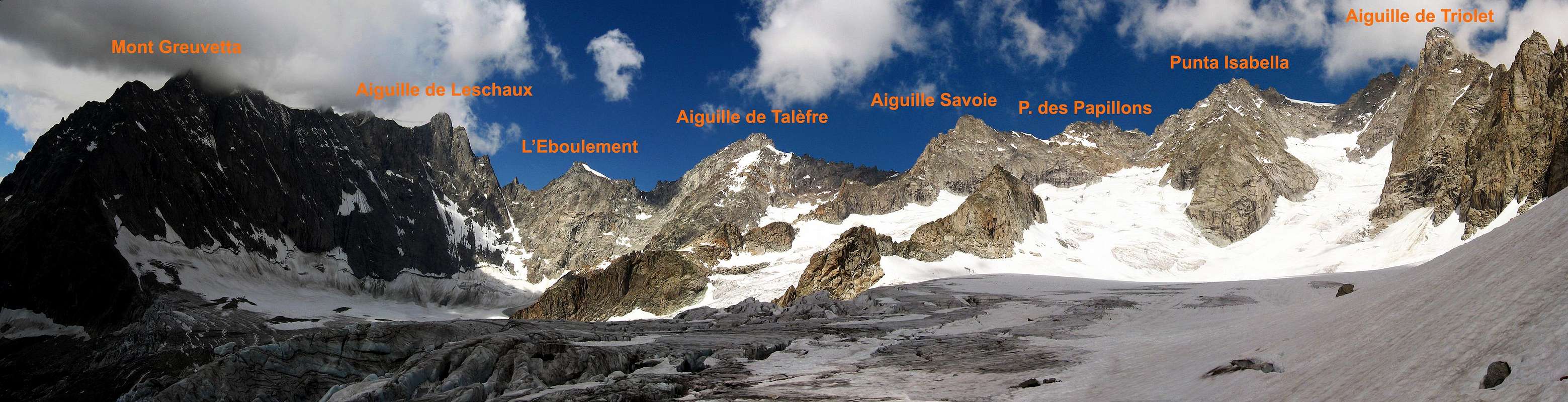
- South Side - Panoramic View of the Triolet basin from Mont Grouetta to the Aiguille de Triolet (Photo by andrea.it)
- Luigi Frachey and Gigi Panei 11/09/1939 (here where the famous italian climber "Gabriele Boccalatte" died with Mario Piolti during the first attempt in the 1938), 4°/5°, from ref.Dalmazzi
- AD, 3-4 h from ref.Dalmazzi, (rarely climbed)
- AD, 7-9 h from biv. Fiorio, very nice, good rocks
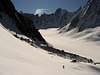
- * Bivouac Fiorio and PRE DE BAR Glacier - Photos by besucher01, andrea.it and Gabriele Roth
 |  |  |
| Bivouac Fiorio | Aiguille de Triolet | PRE DE BAR Glacier |
- D, 6 h from biv. Fiorio, (nice route)
- PD, III, 1,5-2 h from the Col de Triolet, 3703 m. 5,5 - 7 h from Ref. du Couvercle (Eberlein, Mont-Blanc-Gruppe).
- AD, III, 500 hm, to Brèche 2,5 h, from here to the summit 3,5 h (Eberlein).
- 55°, partly 60°, 700 hm, 6,5 - 8 h (Vanis): The most beautiful one of the beautiful ones!) 4 - 8 h (face), 800 hm (Rébuffat): excellent technique and a sound balance, physical and mental, are necessary! V 2, 60°/65°, 800 hm (Damilano/Perroux.)
- * Aiguille de Triolet - North Face - Photos from andrea.it, Rahel Maria Liu/Photo credit, barrys and AlbertoRampini
 |  |  |  |
| North Side | North Face | Panorama | Early Morning |
- TD-, 58° (steepest passage), 54° (average), 6 - 8 h from the foot (on 3120 m) (Eberlein).
- * Aiguille de Triolet - North Face with the „Gréloz-Roch" - Photos from Rahel Maria Liu/Photo credit and pslang
 |  |  |
| Route | Sunrise | Gréloz-Roch |
- TD-, 55° - 60 ° (steepest passage), 54° (average), 6-8 h, objectively dangerous (Eberlein), V 3, 70° (Damilano/Perroux).
Getting There
To the Aiguille de Triolet- You can come from the Refuge d'Argentière.
You can come from the Refuge du Couvercle.
You can come from the Bivouac Fiorio.
You can come from the Refugio Dalmazzi.
- In order to reach the hut, you have 3 possibilities:
From Croix de Lognan (1970 m) in 3 - 3,5 h, to Croix de Lognan with cable car from Argentière.
From Croix de Lognan, you go on foot up over the morainecrest till about 2250m. Than you continue horizontally to the glacier, which you follow on the orographically left side. After about 1 km, the glacier becomes steeper and more torn.
You climb onto the morain of the Rognons, first over a slippery shelf, than via a marked way which you follow until you reach the upper end of the ice break.
You climb the glacier in SE direction and reach over the moraine the hut.
On foot from Argentière in 5 h: From the ground station of the cable car, you follow the wide aisle of the ski-run.
You leave it at the height of about 1750m and reach the way of the middle station of the cable car (2 h). Now, you need 3 h to the hut.
From Aiguille des Grands Montets (summit station of the cable car from Argentière; last train up: 4:45 p.m.) in 2 h.
From the summit station, you go via a stairway to the Col des Grandes Montets. You traverse a bergschrund (maybe with the help of a rope) and go up the steep hang to the Glacier Rognons.
You go with ENE direction on the western side along P. 3000 to P. 2754m. You go down southeastern to the glacier d'Argentière, which you reach above the icebreak. From here in 2 h to the hut.
You reach Argentière by train (from Martigny/CH or Geneva or Annecy - TGV to St. Gervais), bus (from Annecy, Geneva, Grenoble, Courmayeur, Aoste and Turin) or car from Geneva or Martigny (Switzerland) via Vallorcine and the Col des Montets.
- You reach the hut from Montenvers in 3,5 h over the glacier. From Montenvers to the starting point of the hiking way to the Refuge d'Envers des Aiguilles.
You have to follow the way with direction to Les Echelles which goes slightly down to the western side of the Mer de Glace. But before you enter the Glacier, you have to follow the way on the western side of the glacier for about 20 min.
Now you have to go up the glacier first more on the western side, then just through the middle with SE direction to Les Moulins. Now you do not follow the marking signs to the moraines but continue with S and then E direction to the steep passages at Les Egralets (partly a little bit like a way).
You go the steep passages up and via a good way through grass hangs to a moraine, from which you reach the hut soon.
You can reach the hut via a new climbing track below the Flammes de Pierre and the ends of the Aig. du Moine to the Ref. du Couvercle.
But because of ice avalanches, some passages of this route have become very dangerous.
You have to ask for the actual conditions. 3,5 h from Montenvers to Couvercle.
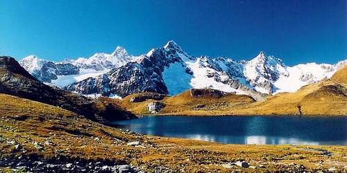 Aiguille de Triolet and Lac de Fenêtre - Photo by Henk van den Akker
 |
- With the special Montenvers-train from Chamonix. The train goes the whole year except from the middle of November till the middle of December. The first train starts during the season often not before 8 a.m., the last train down not after 6.30 p.m.
Or on foot from Chamonix on the marked way via Biollay in 2,5
You reach Chamonix by train (from Martigny/CH or Geneva or Annecy - TGV to St. Gervais), bus (from Annecy, Geneva, Grenoble, Courmayeur, Aoste and Turin) or car from Geneva or Martigny (Switzerland) via Vallorcine, the Col des Montets and Argentière.
- You reach the hut from the end of the road near Arnouva 1900m.
First, you follow the way in direction of Col Ferret. At the first sharp bend, you left over the Doire (there is a sign). You follow the way over the moraine to its end. Now you go right over rock (a little bit marked) up through a groove. You climb the exposed way up. Short below the hut, you climb through a chimney. (I/II). 2,5 h. You reach Arnuva (1769m) via the road of the Val Ferret (Italy) from Courmayeur via Planpincieux, 1564m, and la Vachey, 1642m. During summer, there goes a bus to Arnuva.
- There are 2 bivouacs Fiorio. The old with 6 beds and the brand new with 18 beds, 50 meters far from each others. The route to the bivouac starts from the village of Arnouva 1900m. On gravel road first and than on path n.24 to "Col Ferret". 3 hours E
You reach Arnuva (1769m) via the road of the Val Ferret (Italy) from Courmayeur via Planpincieux, 1564m, and la Vachey, 1642m. During summer, there goes a bus to Arnuva.
- From Martigny (Switzerland) via Vallorcine.
From Geneva (airport) via Anncey (TGV till here) and St. Gervais.
- From/via Annecy, Geneva, Grenoble, Courmayeur, Aoste and Turin
- From Geneva (from the NW) on the A40 till St. Gervais and from here on the N205.
From Martigny (from the NE, Switzerland) via Vallorcine and the Col des Montets on the road no. N506.
- From Chamonix through the Mont Blanc Tunnel from the NW.
From Torino (from the SE) on the A5 via Villeneuve.
Infos
* What a view of Aiguille de Triolet from the south and from the north! Photos by Hiltrud Liu - BigLee - om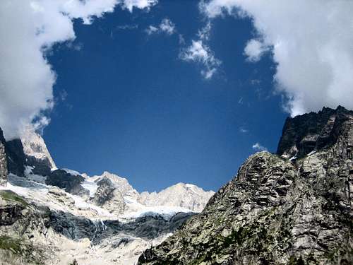 What a view What a view | 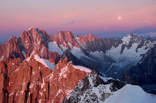 Sunset Sunset | 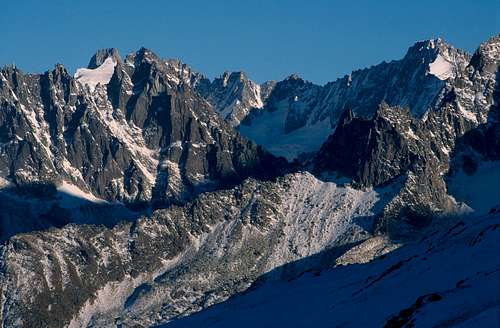 Triolet - Talèfre Triolet - Talèfre |
- Météo France
Phone: 0033/836680274
Snowinfo: 0033/836 681 020 (only in France)
Chamonix
- Office de Haute Montagnes (OHM)
Phone: 0033450 532 208
Bureau des Guides in Chamonix
Phone: 0033/450530088
Chamonix
Guide Alpine Courmayeur
Società Guide Alpine Courmayeur
Courmayeur
- Phone: 0033/450 53 1298 - 0033/8 36 35 35 35 -
0033/450530702 (Train station Chamonix)
Phone of the Montenvers-train: ++33(0)450/531254
Ticket shop
- Phone: 0033/450 53 0555 - 0033/450 53 0115
- Chamonix
Courmayeur
Phone: 00390/165.846658, Fax 00390/165.842347
Maps
* Panorama from the East, from Lac du Fenêtre - Photo by Vid Pogachnik (July, 1989)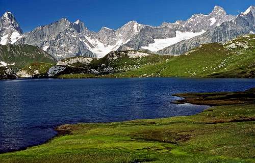 On the very left Grandes Jorasses, on the right Aiguille de Triolet On the very left Grandes Jorasses, on the right Aiguille de Triolet |
- 1:25000 no. 3630 OT Chamonix - Massif du Mont Blanc
- 1:25000 no. 165107 IGC Monte Bianco
 Mont Blanc Area Mont Blanc Area |
Accomodation
* A view of Prè de Bar Glacier about 100 metres above the Fiorio bivouac (2724 m) - Photo by Zed Prè de Bar Glacier Prè de Bar Glacier |
 | Refuge d'Argentière is a modern big hut with a view directly towards the northfaces on the opposite side: from Aiguille Verte to Mont Dolent. It is situated near the corner where the Glacier d'Argentière and the Glacier des Améthystes come together. |
- Tél : 33 (0)4 50 53 16 92 - Email: refugeargentiere@wanadoo.fr
Guarded Fom the end of June to mid-September
Places number : 150
- You reach the Refuge d'Argentière:
from Croix de Lognan (1970 m) in 3 - 3,5 h, to Croix de Lognan with cable car from Argentière
on foot from Argentière in 5 h
from Aiguille des Grands Montets (summit station of the cable car from Argentière) in 2 h
 | Refuge du Couvercle | is situated very nicely in the region of the Aiguille du Moine. It is visited frequently. Instead of the old hut, a new big house was built in 1952. |
- Tél : 33 (0)4 50 53 16 94
Guarded from mid-June to mid-September
Places number: 120
- You reach the Refuge du Couvercle:
from Montenvers in 3,5 h via moraines
via the Balcon du Mer de Glace in 3,5 h
 | Rifugio Dalmazzi (also called Ref. du Triolet) is located below the relatively lonely Glacier de Triolet. |
- Tel. Rifugio: +39 0165/869098 - E-mail: info@rifugiodalmazzi.com/sgonny@inwind.it
Apertura 2008: dal 14 giugno al 14 settembre
- You reach the Rifugio Dalmazzi: from Arnuva
 | Bivouacs Cesare Fiorio (2 sructure, the old and the brand new) rise on a flat debris in the left side of the Glacier Pré de Bar. |
- Property: CAAI 6+18 places, open permanently
- From Arnuva in 3 hours, path 24
Books
- Hartmut Eberlein, Mont-Blanc-Gruppe. Gebietsführer für Bergsteiger und Kletterer, 2000 or 2012.
Helmut Dumler/Willi P. Burkhardt, The High Mountains of the Alps.
Gaston Rébuffat: The Mont Blanc Massif. The 100 Finest Routes. London 1996. ISBN 1-898573-03-4.
Hartmut Eberlein, Mont Blanc. 53 Skitouren, 2009.
Erich Vanis, Im steilen Eis. 80 Eiswände in den Alpen. Munich et al. 1980. ISBN 3-405-12158-2.
Damilano/Perroux, Neige, Glace Et Mixte: Mont Blanc. Editions Ice 1996. ISBN 2950986803.
Lindsay Griffin, Mont Blanc Massif, Vol. 2 - Published Alpine Club (2002).
Laroche/Lelong, Die Gipfel des Montblanc. Munich 1999. ISBN 3-405-15693-9.
Helmut Dumler/Willi P. Burkhardt, Viertausender der Alpen. 11th ed. Munich 1998.
Gino Buscaini, MONTE BIANCO, Vol. II, Guida dei Monti d'Italia, 1983.
| Michael Waeber, Haute Route (Rother Skitourenführer with map) |
Link MountainArea
 Aiguille de Triolet and Mont Gruetta - Photo from om
 | MountainArea |
Google Map
 Google Map - Photo from markhallam Google Map - Photo from markhallam |