

-
 195463 Hits
-
 99.32% Score
-
 106 Votes
|
|
Mountain/Rock |
|---|---|
|
|
19.17860°N / 98.64188°W |
|
|
Mountaineering |
|
|
17159 ft / 5230 m |
|
|
In Memoriam
On Saturday, November 20, 2010, Chris Pruchnic (Haliku) lost his life in an ice-climbing accident in Colorado's Rocky Mountain National Park. Haliku was a valued contributor to SP, but his worth went well beyond the pages he created and is missed very much both from friends who have climbed with him, and by anyone who asked him for advice about climbing. I am honored to be able to continue managing this page and I believe it is in the best interest to keep as much of the text Chris wrote intact and that's exactly what I will do. Anything added will be clearly marked and credit will clearly be given to sections written by Chris. Although I never had the chance to meet him, he will be missed and as a member of the climbing community, he will never be forgotten. Written below is a beautiful tribute from one of his long time friends.
He always was willing to give a hand or advice to anyone in anyway that he could, and he always wanted to share his joy of climbing and exploring other cultures with his friends and fellow climbers. The climbing community and the world needs more people like Chris, not less, which makes the tragedy of his early parting so much more difficult to accept. He will live on in our hearts and memories. He and I had been talking about climbing Kilimanjaro soon, and someday when I stand atop that peak I will call Chris' name to honor my friend. --chicagotransplant
Overview
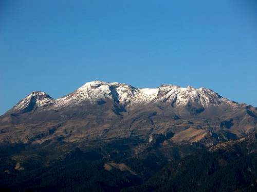
The sleeping lady
Iztaccihuatl (a.k.a. Ixtaccihuatl, Izta, or Ixta) is the third highest mountain in Mexico and the seventh highest in North America. An extinct volcano, Ixta is a unique mountain. When viewed from either the west or the east you can distinctly see her; the sleeping lady. The north end of the mountain is 'the head'. A big dip, 'the neck', and then up to the summit of the sleeping lady, her 'breasts'. The rest of the mountain follows in logical progression, the stomach (glaciated), the knees, and the feet which is the sub peak at the south end of the mountain.
So in review from head to toes:
La Cabellera: the hair
La Cabeza: the head
La Oreja: the ear
El Cuello: the neck
El Pecho: the breast
La Barriga: the belly or La Pansa: the stomach
Las Rodillas: the knees
Los Pies: the feet
Ixta sees a lot of traffic, both internationally and domestic. All skill levels of mountaineers seek to gain the summit. From the young 12 year old mexican boy, on his first trip to the mountains with grandpa, to the American from the Pacific NW that has visited Rainier over 20 times, you see it all on Ixta.
Most people choose the standard route on Ixta, also known as La Arista del Sol (The Ridge of the Sun). The route climbs past the feet and up the knees across the stomach and onto the breasts. The technical level is low but the effects of altitude are commonly felt and climbers often push to the summit too quickly. Being dropped off at over 4000m and only facing a 5-8 hour trip to the summit is very tempting but resist and take the time and acclimatize.
Iztaccihuatl-Popocatepetl and Zoquiapan National Parks and their ecological importance
The Iztaccihuatl-Popocatepetl National Park was created in 1935 with an area of 25,679 hectares. In 1937 the lands of the former hacienda of Zoquiapan were incorporated increasing the area under protection to more than 45,000 hectares. The sylvan flora and fauna of the park are of nearctic and neotropical origin. In its geographic location it forms a part of the trans-Mexican volcanic zone, enabling it to have a great diversity of habitats, such as mixed forests of pine, evergreen oak and alnus, as well as high mountain prairies. Alpine habitats can be found at the highest altitudes, a great rarity in Mexico as the country is located in the subtropical zone.
These forests house nearly a thousand species of plants, comprising 45% of the reported species in the Valley of Mexico and 5% of the phanerogamous flora in the country. For its part, the fauna is an extraordinary richness of species, including mammals such as the zacatuche or teporingo rabbit, the puma, the lynx, the coati and the white-tailed deer, which constitute 40% of registered mammals in the Sierra Nevada. Also, the volcanic corridor serves as a resting point for diverse species of birds on their migratory routes to the Gulf and the Pacific.
Overview section written by Chris
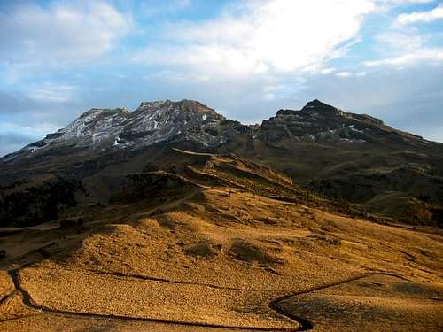 View of Izta near Paso de Cortez View of Izta near Paso de Cortez |
 Starting the trail from La Joya Starting the trail from La Joya |
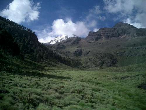 In the valley below the trailhead In the valley below the trailhead |
Getting There
First you have to get to Paso de Cortez (around 3800m) and then on to La Joya (a bit over 4000m) where the trail starts. You can get to the Paso either from Amecameca on the Mexico City side via a windy paved road through a beautiful forest, or from San Nicolas de los Ranchos on the Puebla side on an unpaved road. To get from the Paso to La Joya you need a permit (see the Red Tape section).
Getting to Paso de Cortez from Amecameca (Mexico City):
From the International Airport in Mexico City, go to the TAPO bus station by Metro, Bus or Taxi (expensive). There you can take one of the different buses to the town of Amecameca. They leave every 15 minutes from about 4:00 all the way until midnight. In Amecameca there are several hotels, check your Mexico guidebook (Lonelyplanet has information). People have recommended hotel San Carlos, right on the Zocalo (main square) where the bus drops you off. While in town we stayed several blocks away from the square at a clean and cheap place called Hotel El Marques. It was nothing fancy but they had plenty of hot water.
From Amecameca you can get a taxi that should bring you all the way up to La Joya. Usually a one way ride to La Joya costs between 200 and 300 Pesos, depending on your Spanish and negociating skills. Alternatively there also collectivos (small buses) going up to the Paso de Cortez, which is a lot cheaper. From there you would have to walk or ask someone for a ride to La Joya.
While in Amecameca, any last minute supplies and food can be picked up in the lively market. While most of the vendors sell fresh foods, there are some selling basic items you would find in a grocery store. A couple ATM's also exist around the town center.
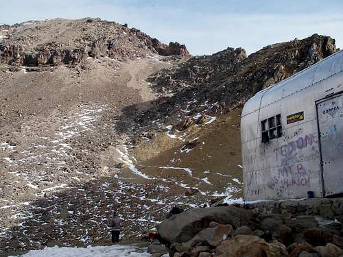
 Altzomoni Hut Altzomoni Hut |
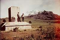 Historic Image Historic Image |
Getting to the Paso de Cortez from San Nicolas de los Ranchos (Puebla):
If you want to avoid Mexico City or for some other reason already are in Puebla you can also get to Paso de Cortez without any problem from this side. From the airport there are direct buses to Puebla (110 Pesos). Be sure to take the one that takes you to the CAPU (main bus station in Puebla) and not the one that goes to the center. From the CAPU, there are tons of buses to Cholula. Take the fast one, which costs you about 15 Pesos. From Cholula take a small collectivo to San Nicolas de los Ranchos (10 Pesos). The trip to Puebla takes about 2 hours and from there to San Nicolas another one to two hours.
From San Nicolas you will have to get a taxi. As you get out of the bus on the Zocalo people will probably recognize you as a climber and ask you if you want a ride to La Joya. You will also pay between 200 and 300 Pesos, depending on your spanish and communication skills. Be sure that he brings you all the way to La Joya and not only to Paso de Cortez. If you are nice to your driver, they might help you coorspond with the rangers at the Paso to make purchasing your permit more efficient.
From Paso de Cortez to La Joya:
If you take a taxi either from Amecameca or San Nicolas de los Ranchos, be sure that the price includes the drive all the way up to La Joya (to the hut and the big parking area, not somewhere in between!) The road gets worse at the very end and descends about 40 feet on a rough cobblestone hill so drivers tend to stop somewhere before La Joya however most of it is fairly smooth dirt. The road is only open from 8:00am to 6:00pm and you need permit to pass the gate (see Red Tape section). If somehow you can only get to Paso de Cortez, wait at the gate for someone that can give you a lift. On weekends lots of people drive up there. Or you can also walk the 8km dirt road to La Joya. Once at La Joya, there is a hut next to the parking area that sometimes sells fresh food, water, and possibly some basic hiking gear. Both times I was at La Joya the hut was deserted though.
With your own car:
Even VW Bugs or Cadillacs make it all the way to the La Joya hut, so you should have no problem driving up there. The end of the La Joya road is a bit bumpy, if you want you can leave your car about 1km before the end of the road, just after the intersection with the road to the Radio/TV-station. Leaving the car in La Joya for one or two nights should not be an issue. I haven't heard of any robberies or other problems in the past. You can also drive to La Joya and spend your first night there instead of Amecameca or Puebla.
From Puebla there is an alternate and really nice road to Paso de Cortez. From Calpan, follow the signs to the Centro Touristico, a center with huts you can rent. The first part of the road is a bit more offroad then the San Nicolas road, but you should have no problem passing it. From the Centro Touristico you will reach the "normal" road to Paso de Cortez.
Getting back:
If you don't have your own car and want to be on the safe side, arrange a drive down with the taxi driver that brought you up. This isn't really recommend because you'll have to be back in La Joya at a certain time, and you don't really know if he shows up (DON'T pay in advance). This will also cost another 200 to 300 Pesos. On a sunny weekend hundreds of people go up there for hiking, picnic, or even climbing Izta itself. You should have no problem getting a ride. Even if you really are totally alone, you can still walk down to Paso de Cortez and from there take a collective or ask people that are driving through.
Getting there section largely written by Chris
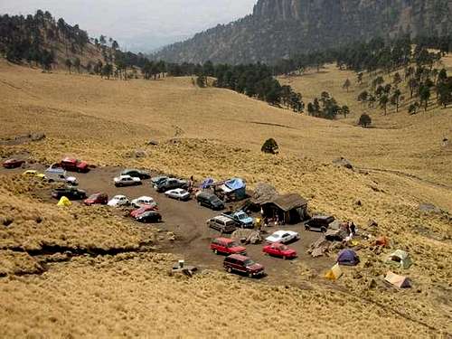 La Joya on a sunday afternoon La Joya on a sunday afternoon |
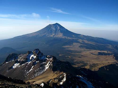
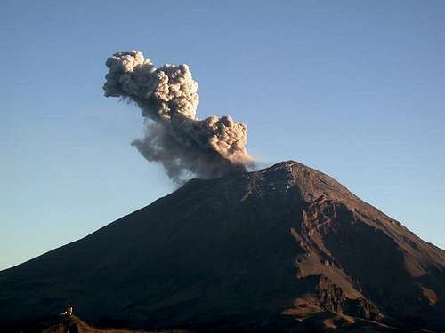 Popo seen from La Joya Popo seen from La Joya |
Transportation
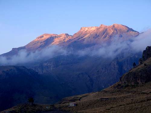
Iztaccihuatl sunset from La Joya
Although many people use the bus system to get from their arrival airport to various towns and trailheads, some people would prefer to avoid them due to instances of losing their gear either at checkpoints or due to someone robbing the bus. There have also been a few cases where drug cartels have hijacked a public transportation bus and robbed tourists but recently, this has declined significantly and this has only been an issue closer to the US/Mexico border or coastal cities like Veracruz.
If you do decide to avoid the bus system, you can hire a private driver (different than a taxi) who will be able to pick you up directly from the airport and take you and you gear where ever you need to go. This is what I did when I climbed Izta and it worked out very well. Not only will you get around more efficiently, but you will have someone to talk to on the ride and feel a little safer. Taking a taxi can sometimes lead to being ripped off. Listed below is the best option for a private driver. Antonio is very nice and very reasonable on pricing. Although it will be more expensive than buses or taxis (around $75 per person for just Izta), it's well worth it. Hiring a driver is actually better if you are in a large group. Antonio has both a large van and a Volkswagon car. His van can carry up to 8 people including gear and will be cheaper since you can split the cost with the amount of people in your group.
Jesus Antonio Juarez Guzman
044-55-39080-242 cell
jajuarezgu@yahoo.com.mx
Transportation section written by Matt
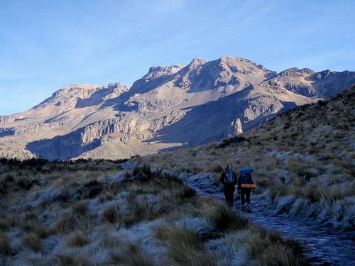
Standard Route
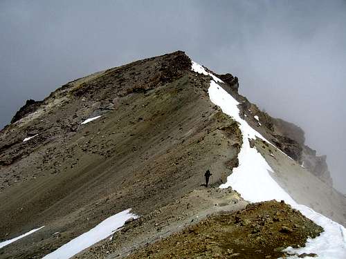
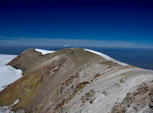
The standard route on Izta is ther La Arista del Sol (Ridge of the Sun) route and begins from the La Joya trailhead at 13,040 feet in elevation (see Getting There above). From the trailhead parking area, locate a large trail heading steeply up the hill to the east for 80 feet or so and meets with the main trail, turning left (north) and begins a gentle traverse up the slopes. The first photo in the table below shows the trail. Follow this large trail for a quarter mile to a smaller, older parking area at 13,140 feet that's no longer used. From here, it's very important you veer right and take the trail that heads up the hill. Do not continue straight as this lesser used trail eventually descends down into the valley below. Pass below a series of cliffs and reach the crest of a small ridge 1 mile from La Joya at 13,950 feet. Continue on the trail over the ridge where it traverses slightly east before making a short but steep ascent on loose scree to a second saddle at 14,440 feet. Here you have your first views of the upper mountain and a small rock tower is seen directly to the west. I captured a beautiful eerie photo from this second saddle where fast moving clouds engulfed us.
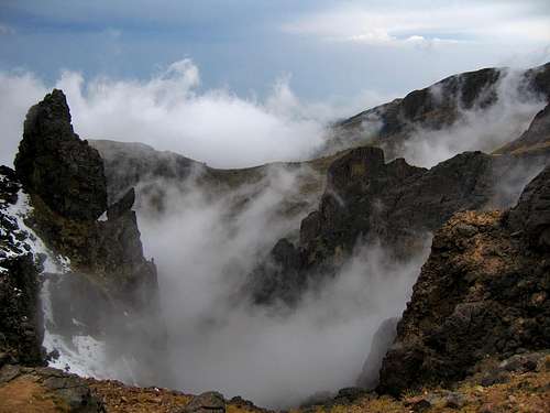 View from the second saddle
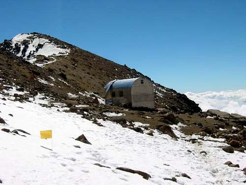
Looking up and to the right, the trail continues up along the ridge for 50 feet before crossing to the north side of the saddle and traversing to the west od the craggy peak above which is "The Feet" of the sleeping woman. Just under a half mile from the second saddle, you will reach a third saddle at 14,860 feet which marks the low point between The Feet and The Knees. A small flat area to camp can be found here but will be very busy as you are right along the main trail. Cross to the east side of the main crest and follow the trail below the crags and continue up a steep, Class 3 section to regain the ridge crest. There are many ways to scramble this 100 foot spot but they are all loose. Once back on the ridge, continue another few minutes to the Grupo de Los Cien hut at 15,470 feet (See second photo in the table below). There is room for 15-20 people in the hut and will fill up on weekends in February and March. Get there early, or bring your own tent. It's 2.5 miles from La Joya to the hut on the trail.
From the hut, continue north up a steep scree slope and aim for the path of least resistance through the broken rock up to the summit of The Knees. This is the crux of the route and requires about 300 feet of Class 2+ scrambling. The easiest route is marked with yellow dots on the rocks. You should also pass by a large, 3 foot iron cross marking the start of the scrambling. You will also find numerous other crosses surrounding the hut signifying fallen climbers I would guess. Once atop the Knees at 16,500 feet, where the remains of an old hut are found, begin the long, but easy traverse along the ridge towards "The Breasts" which is the true summit. It's still a 1.5 mile hike from The Knees to the true summit so plan on being well above 16,000 feet for at least 4 hours. Once you drop off the north side of The Knees (Class 3 step), the rest of the traverse is easy going from one false summit to the next.
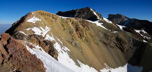 The remaining route seen from The Knees
There are some snowfields that will have to be crossed closer to the summit but they are very low angle and mostly flat. I made the hike in trail runners and strap-on crampons. Unless there is a lot of snow on the mountain, you should be fine in light boots. Once you reach the old summit crater (which is obvious once you get to it), you simply hike directly across it on the flat snowfield and make the final few feet to the highest point on the north side of the crater marked by a somewhat broken large cross. Although it may look like the south side of the crater is higher, it isn't however if the clouds are moving in (which they will) many people are content to stop here. The photo directly below shows the traverse from the south side of the crater looking south. Return the way you came.
 Looking south from the south side of the crater. The Knees are out of view
 Starting up the trail from La Joya Starting up the trail from La Joya |
 Looking up the rock scramble to the knees Looking up the rock scramble to the knees |
 Traversing La Arista del Sol Traversing La Arista del Sol |
 Looking down on the feet from the knees Looking down on the feet from the knees |
 The ridge traverse route after the knees The ridge traverse route after the knees |
 Final bit to the summit Final bit to the summit |
| Informative Trip Reports |
| March 2012 Spring Break in Mexico - Matt Lemke November 2009 10 Days in Mexico - Gimpilator February 2009 Iztaccihuatl - SawtoothSean January 2008 Iztaccihuatl - MountainHikerCO March 2008 Mexican Vacation - Astrobassman March 2007 Chasing the Glaciers in Mexico - doumall January 2007 Iztaccihuatl: The Long Day Hike - 1mvertical |
Standard Route section written by Matt. Click on the link at the top to see the description Chris originally wrote. The table above was originally composed by Chris but edited by Matt
Standard Route Map
Map above generated by Matt - Zoom in and out or change the map type using the drop down menu in the upper right corner.
Red Tape
The road to Paso de Cortez is sometimes closed due to the activity of Popocatepetl. Green lamp (usually no smoke) means that everthing is fine, yellow lamp (usually a little smoke) is warning and a red lamp (usually heavy smoke) means you cannot pass.
To pass the gate (open from 8:00am to 6:00pm) from Paso de Cortez to La Joya you will need to buy a permit (even if you come with a taxi, even if there is a green lamp). There are a couple ways to get it. The first option you have is you can go to the Izta-Popo National Park Headquarters located in the town square in Amecameca. It's between the church and the bank. The ranger station is set back about twenty yards up the stairs. It's 22.50 pesos per person per day for the permit. You will sign some paperwork and be required to keep the permit with you on the mountain. You must get the permit this before going to La Joya.
The other option is to get it at Paso de Cortez. There is no need to stop in Amecameca if you don't want to. The rangers at Paso de Cortez are not there at night so plan to arrive and get your permit in the morning or early afternoon. At La Joya, there is a yellow box that contains the Socorro Alpino (Alpine Rescue) registration book. It is recommended that you sign in here.
Red tape section mostly written by Matt
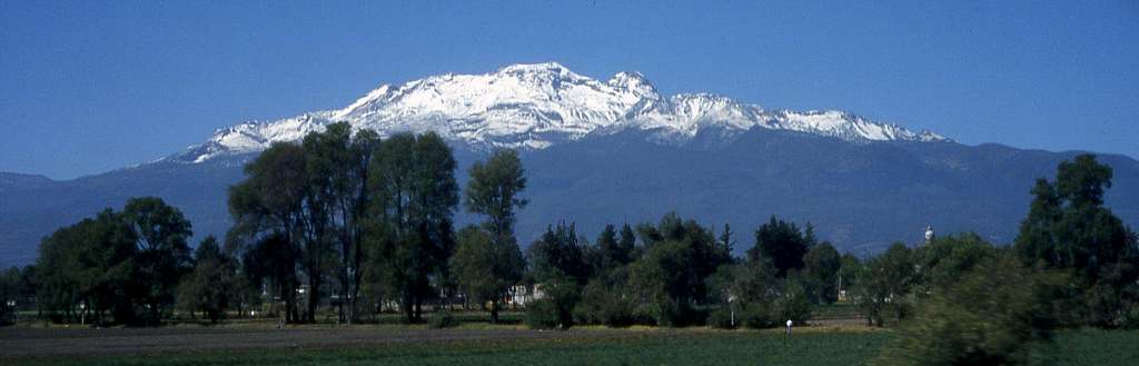 Iztaccihuatl from the plains near Amecameca
When To Climb
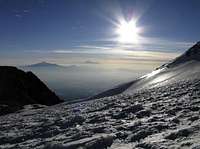
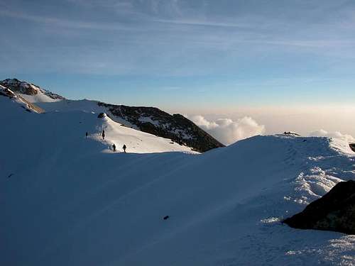
Sunrise

Typical afternoon fog
Iztaccíhuatl can be climbed at almost any time of the year, but the best conditions with the least amount of snow or rain are in December thru early March. April and May are traditionally wet and the rest of the season you never fully know what your getting with the weather. The vast majority of people climb it in February and March and weekends during this time bring literally hundreds of people to La Joya.
TIME OF DAY
Get an early start. A frequent weather pattern brings in clouds in the early afternoon which often dissipate in early evening. Many people try the standard route in a day as it's only about 9 miles round trip and gains about 4,000 feet in elevation but it's recommended you take a day or two to acclimate if you came from sea level. The route above the Grupo de los Cien hut takes longer than everyone thinks. Most parties hike to the hut the first afternoon and camp and make an early sunrise start on summit day. It's best to be back to the hut before noon as it's common for a white-out to form after noon making the return hike somewhat more difficult.
Guidebooks & Guides
Guide Books
RJ Secor's guidebook for Mexico's Volcanoes: A Climbing Guide is one source of information on climbing all the major mountains in Mexico. Published by The Mountaineers
For complete information on getting to Mexico and traveling around I highly recommend the Lonely Planet guidebook on Mexico, now on their 11th edition.
Then there is a Spanish guidebook about Iztaccihuatl named "Iztaccihuatl" by Alfredo Careaga Pardave. It has lots of Information about the mountain (Histoy, Geology etc.) and many routes.
Guides
Roberto Flores Rodriguez aka Oso
oso_expediciones@hotmail.com
Orizaba Mountain Guides
Ruben Garcia cell 044-55-533-22-861
cumbre7@hotmail.com
Cumbre 7
Possible Schedules
If you're already acclimated:
Day 1 - Fly into Mexico City, take a taxi to La Tapo, catch a bus to Amecameca, find hotel accomadation, purchase food, water and supplies, arrange a ride for the morning, get a good night rest. I had good luck eating in the market for all meals. Most likely you'll be eating with the locals as well as other climbers.
Day 2 - Catch the ride up to La Joya (stopping at the Paso for permit). Hike up to the Grupo de los Cien hut at 4750m and spend the night. There is a nice trail all the way to the hut with the final couple hundred feet being a loose but easy scramble.
Day 3 - Summit via the standard La Arista del Sol Route and return to your either pre-planned or spontaneous ride at La Joya. Go down to Amecameca and have tacos and a few beers.
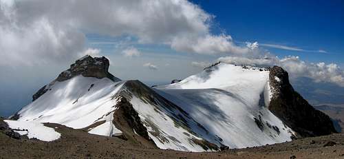
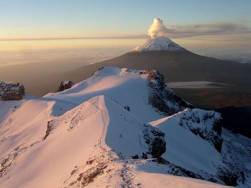 A snowy Izta with Popo behind A snowy Izta with Popo behind |
 Grupo de Los Cien hut Grupo de Los Cien hut |
If you are not acclimated:
Day 1 - Fly into Mexico City, take a taxi to La Tapo, catch a bus to Amecameca, find hotel accomadation, purchase food, water and supplies, arrange a ride for the morning, get a good night rest. I had good luck eating in the market for all meals. Most likely you'll be eating with the locals as well as other climbers.
Day 2 - Catch the ride up to La Joya (stopping at the Paso for permit). Take a day hike without the heavy packs up to the first or second saddle on the trail (about halfway to the hut) and return to La Joya and camp at the trailhead.
Day 3 - Hike the trail all the way to the Grupo de los Cien hut with all your gear. The hut is about 15,000 feet in elevation.
Day 4 - Summit via the standard La Arista del Sol Route and return to your either pre-planned or spontaneous ride at La Joya. Go down to Amecameca and have tacos and a few beers.
Water
There is no reliable water source at all on Ixta's normal route. The last place where you can get water is at Paso de Cortez (only small bottles) or on busy weekends also at La Joya. It's best to buy a bunch of bottles in town before heading up to Paso de Cortez. Bring enough for at least three days!
External Links
Good forecast from Mountain-Forecast
For some volcanic eruption history see this link.
For weather and trip reports. When you bring up the site, click on the upper left button for English translation of the pages.
For information on the mountain and the surrounding park in Spanish check this site.
Scott - Dec 31, 2016 8:12 pm - Voted 10/10
IMPORTANT!If you want to stay in the Altzomoni Lodge (Albergue), apparently you are supposed to get the key in Amecameca (though one online source says Paso de Cortes?). We didn't know this and got all the way up there with no key and we left the tent down in Amecameca.
MishaCZ - Aug 7, 2017 12:30 pm - Hasn't voted
LogisticsWe stayed at the hut at Paso de Cortes since the Altzomoni hut is easily booked out. For logistics, we used a local company from Mexico City who offer transportation, lodging at Paso de Cortes and food+water (before your climb, lunch for your backpack and warm lunch at your return) for a really good price and I'm happily passing over their contact: nomadatravelmexico at gmail.
Oleksii Pivtorak - Oct 13, 2018 1:06 pm - Hasn't voted
About a permit of ascension.Hi, I want climb Iza in this December but I’m 17 years old. I will climb it with my 25 years old friend, will I have a problem to get my permit because of my age!? Tnank you! Oleksii Pivtorak
Bertrand - Dec 18, 2018 1:01 am - Hasn't voted
Few comments- Day 0: we stayed at Hotel Fontesanta, great hotel for the value. The bus from Mexico city can drop you off in front of it. Hitchhiking or taking a collectivo to Paso de Cortez can be done easily from A Tlamapas road. - Day 1: If you camp at la Joya, try to set up your campsite isolated, far from the parking. It can be noisy at night. - Day 2: Grupo de Los Cien is full of mouses. Be careful with your food. There are not really afraid by humans, if you sleep in lower banks, they would jump on your sleeping back during the night. - Day 3: Crampons were highly recommended, we did not use them. - I did the ascension from Saturday to Monday in Mid-December. Trails were crowded on Saturday and Sunday. We were alone on Monday and did cross only 2 people around to la Joya.
felixrulz - May 5, 2019 8:12 pm - Voted 8/10
Entrance FeeWas up there the last two days. The entrance fee is now 36 pesos per day.
AnniinaH6C9trXd - Jan 6, 2020 3:01 am - Voted 1/10
Transport from PueblaThere are buses from Cholula to Xalitzintla from where a bus every 1-2 hours to Paso de Cortez (going all the way to Amecameca). No taxis in Xalitzintla or San Nicolas de los Ranchos as of Sept. 2019 and they hadn't heard of them. In September it would be completely impossible without crampones, conditions were all the way very snowy and icy.
DaveCovill - Mar 26, 2020 2:15 pm - Hasn't voted
Izta thoughtsI've climbed Izta 2X now, and was on the mountain climbing The Feet only this year (Los Pies). We climbed on January 9th 2020, the date of a large eruption on nearby Popo, which occurred about 630AM when we were a couple miles up the trail nearing the saddle between Izta proper and the Feet. I later measured this distance to be about 7 air miles from the summit of Popo. For about 10 seconds I thought we were doomed, then I realized the lava that was spewing forth was merely tumbling down the sides of the mountain. My fears turned to a fire coming across to the Izta parking area, but again that was not to be. For two hours we had ash rain down on us. Click on the link from the observatory camera near the highway saddle: https://earthsky.org/earth/volcano-popocatepetl-eruption-mexico-jan-9-2020?utm_campaign=shareaholic&utm_medium=email_this&utm_source=email You never know what shape the mountain will be in, so come prepared. We dayhike the peak after suitable acclimation hikes, including La Malinche, Sierra Negra, or Nevado de Toluca. No need to camp up high, the hike is manageable if you are acclimated to 15,000'+. This January of 2020, most of the snow was completely gone, microspikes were suitable according to my friends who climbed Izta while I scrambled up The Feet. I agree totally that Antonio Guzman is an excellent choice for transportation from Mexico City to Tlachichuca, and other points of interest. His rates are reasonable, and his English is good. Great guy. He can handle up to 8 or so in his large van, and he can procure an additional driver as needed. He knows where to stay, eat, etc. Another guide who has hundreds of ascents on Orizaba and Izta is Vicente Azpeitia. Vicente can provide transportation to a smaller group of a few climbers, and will accompany the group to other peaks. His English is Fair at best, so it would be in your best interests to have at least one member of the team have a moderate ability to speak Spanish. Again, great guy. vicenteazpeitia@yahoo.com.mx Finally, if you find yourself in the city of Puebla halfway between Mexico City and Tlachichuca, perhaps while climbing La Malinche, seek out the Puebla Plate Lady. Her name is Concepcion Perez, and she sits on a street corner near the famous market alley. She creates artwork on a plate via finger painting with acrylic paint. Her subjects are of course the volcanoes; Popo, Izta, Orizaba. Cost is minimal, perhaps ~$10. She made 8 or so for us in a few hours while we had dinner nearby. Close examination of the finished work reveals the fingerprints, amazing how she does it. She wraps her pieces in plastic wrap to keep them clean until you get home, careful of fresh paint not drying when wrapped tightly... She speaks Zero English... http://www.pueblaplatelady.com/
achiquit - Jan 3, 2024 6:23 am - Hasn't voted
Additional Red TapeIf you're driving your own car or a rental, as of 2023 there is now a requirement to reserve a parking spot at La Joya. If you fail to get this reservation, which must be done at least five days in advance, you have to leave your car at Paso De Cortez and walk or hitchhike the 7 kilometers to La Joya. I believe the reservation can be made at the link below, but I haven't done it because I was surprised by the requirement and hitchhiked to La Joya. https://reservaciones.conanp.gob.mx/vistas/index.php