Overview
It is one of the most popular climbing mountain in Tatra Mts. The easiest route is ca. I and the hardest is VI.4 - "Wariant R".
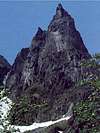
The hardest routes are these on the NE face.
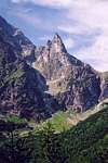
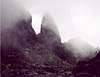
Mnich is located in Dolina Rybiego Potoku (Fish Stream Valley). It is surrounded by smaller valley Za Mnichem and Mnichowy Zleb (Monk's chute).
Built by granite, Mnich has solid rocks and great plates, especially mentioned above these on NE face. Shortest routes are about 2,30 h (from chalet), the longest are probably about 7-8 hrs.
First ascent- Jan Gwalbert Pawlikowski with a guide Maciej Sieczka (1879 or 1880; probably from the West, or maybe route "Przez Plyte"[through The Slab]).
First winter ascent- H. Bednarski, J. Cybulski, W. Goetel, L. Loria and S. Zdyb (6 march 1910)
Getting There
From Cracow (Southern Poland) go to Zakopane (by train (today it is about 20 US$), or by coach(about 4 US$)). From Zakopane take coach to Morskie Oko. From the end of route You have to walk about 9 km. At the end of the road there is a lake, Morskie Oko, the biggest in Tatras (and one of the deepest). On the northern bord of the lake is a chalet. From the chalet NE face of Mnich is seen.
Red Tape
This is a National Park (Polish and Slovakian), so there are some strict rules of wildlife conservation (there are bords, in Polish, German and English) with lists of interdictions. No fauna and flora can be disturbed or collected.
Entry charge to the Park is about 0.50 US$. per day.
When To Climb
The best wheather is in August and September, or, during winter January-March, depends on the snow conditions. In June - July frequent t-storms.
Camping
There is a camp site of Polish Mountaineering Ass., near chalet, but i don't know the conditions of camping for foreigners. In Zakopane are many camp sites. Climbers may also use the Chalet ( as I know, the price for the bed oscillates between 7 and 15 US$).
Books
The best is 24-vol. guide "Tatry Wysokie", written by W. H. Paryski. This book was edited between 1951-1979, and reedited by Sklep Podroznika in 90's. There is no ISBN. About Mnich and surrounding peaks is volume no. IV.
Maps are available in Zakopane - plenty of these, but the best (in my opinion) are:
1:30000 edited by PPWK (costs about 4 US$)
and
1:10000 edited by S³u¿ba Kartograficzna WP (Polish Army), as i know out of print.
There is also 1:10000 edited by G³ówny Geodeta Kraju, I have not seen, about 5 US$ per sheet (22 sheets).
Very good are maps edited by VKU (Slovakia)
1:50 000 Vysoke Tatry 113
also 1:25 000
VKU - order maps
Mountain Conditions
Zakopane Online
- in english
(+48)(18) 20-15-560; 20-14-731 - Tatra Volunteer Rescue, they also have a site, but only in Polish:
TOPR - Tatra Volunteer Rescue
Chalet - (+48 18) 20 77 609
External Links


palaeo - Aug 20, 2003 3:36 am - Hasn't voted
Untitled CommentThere is a topo of E face of Mnich, made by Grzegorz Glazek, and edited by MASTER TOPO. ISBN 83-917651-3-X. More info: fabre@polnet.cc
hopet - Apr 1, 2007 8:37 pm - Hasn't voted
ToposLink to route descriptions with topos in Czech should actually be http://www.climbweb.cz/rocks.php3?stena=153&parent=27,26,11,X,6,2,1 and the topo is linked from there - or you can access it directly here: http://www.climbweb.cz/topa/steny/153.gif