|
|
Mountain/Rock |
|---|---|
|
|
44.15300°N / 71.532°W |
|
|
4698 ft / 1432 m |
|
|
Overview
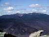
Mount Bond, together with its neighbors West Bond and Bondcliff are, in my opinion, the crown jewels of the White Mountain National Forest. All three rise above treeline, with magnificent views of the surrounding mountains from the three summits and from much of the ridge between Mount Bond and Bondcliff. Fortunately their neighbors are high enough to hide almost all evidence of human activity, except for the summit buildings on Mount Washington and the ski slopes on Loon. Many peakbaggers find their remoteness an obstacle, to me it is their greatest attraction.
It is possible to do all three in one trip, or do Bondcliff in one trip and Bond and West Bond in another. It is possible to do day trips, to backpack, or to use the Appalachian Mountain Club huts, either Zealand Falls Hut or Galehead Hut or both. I have described a great variety of routes, with distances and elevation gains, in the Bonds section of my peakbagging the 4000 footers web site. Here I will just outline the options briefly.
Bondcliff alone can be done by the Wilderness and Bondcliff trails, the distance is 18 miles (round trip), but with an elevation gain of only 3,000 feet it is doable by many hikers who make no claims of extreme fitness. It is also possible to do this over two days as a backpack, as discussed in the Camping section below.
The easiest way of doing Mount Bond and West Bond is from the Zealand Trail, Twinway and Bondcliff trails, this is about 17 miles (round trip) with about 4,000 feet of elevation gain. Once again it can be done in one day, or as an overnight, staying either at Zealand Hut or at the Guyot Campsite.
The three Bonds can be done in a single trip in a variety of ways. The simplest is an in and out trip by the Wilderness and Bondcliff Trails, about 23 miles and 4,500 feet of elevation gain. Experienced bushwhackers often save a couple of miles and about 800 feet of elevation gain by descending from West Bond (various routes are possible) to the Franconia Brook Trail.
With two cars traverses are possible, in by the Wilderness and Bondcliff Trails and out by the Twinway, either eastwards to Zealand or westwards to South Twin. Either trip is around 20 miles with 3,700 to 5,000 feet of elevation gain, depending on which traverse is done and in which direction it is done. Once again the options are many; any of these trips can either be done in a single long day or over two or more days, as a backpack or as a hut based trip.
A bonus from these traverses is that you get still more spectacular views into the Pemi Wilderness. Whichever traverse you do will take you over Guyot, with its 360° views. Coming from Zealand you will pass by Zeacliff, which has excellent (though not 360°) views. Coming from the Twins you will get the 360° views from South Twin, plus two excellent outlooks from North Twin.
My favorite is the Twins Guyot Bonds traverse. You get 360° views from all three Bonds, Guyot and South Twin, plus excellent (though more restricted) views from North Twin.
 |
 |
 |
 |
Getting There
The Wilderness Trail starts at the Lincoln Woods trailhead on the Kanc (NH 112) about 4 miles east of Lincoln.
The Gale River, North Twin Trails start on Forest Service roads that branch off US 3 west of Twin Mountain. The Zealand Trail starts off a Forest Service road that leaves US 302 east of Twin Mountain.
Red Tape
A White Mountain National Forest parking pass is required for all trailheads.
When To Climb
The normal hiking season in the White Mountains extends roughly from Memorial Day to Columbus Day. In winter the exposed ridge between Bondcliff and Mount Bond is often a major obstacle, it is not uncommon for trips to have to turn back because of the weather. Since few people attempt the Bonds in winter deep, unbroken snow can be a serious problem. You may want to read about my epic winter bushwhack before trying it out!
Note that in winter the Forest Service roads leading to the Gale River, North Twin and Zealand trailheads are closed, adding about 3 miles (one way) to any trip that uses these trails. Galehead Hut is closed in winter, Zealand Falls Hut is open on a self-service basis (bring and cook your own food, minimal heat in hut).
 |
Camping
The Galehead Hut is located at the junction of the Garfield Ridge and Twinway trails. It is usually reached by the Gale River and Garfield Ridge trails. From there you may do either Bond and West Bond, or all three, then either return to the hut, or continue to Zealand Hut.
The Zealand Falls Hut is located near the junction of the Twinway and Zealand trails. A longer approach is from Crawford Notch by the Avalon and A-Z trails. Here again you may do two peaks or all three, and either do a round trip or a traverse to Galehead Hut.
Advance reservations are strongly suggested at the huts.
The Guyot campsite is located off the Bondcliff trail in the heart of the Pemigewasset Wilderness. It can be reached by the Zealand trail and the Twinway, by the Wilderness and Bondcliff trails or by the North Twin trail and the Twinway. It has a shelter plus 6 single platforms, there is a caretaker and a fee is charged, but there are no advance reservations. It is usually crowded on weekends, plan to arrive early!
If planning a backpack up the Bondcliff Trail you may either carry your pack over Bondcliff and Bond to camp at the Guyot Campsite, or camp in the backcountry along the Bondcliff Trail. This is in a Wilderness Area, please follow all the Backcountry Camping Rules.
Mountain Conditions
The National Weather Service posts forecasts for the above treeline summits at 3 AM every morning; this is useful if planning to traverse the exposed ridge between Bondcliff and West Bond.
The Appalachian Mountain Club has an information phone at Pinkham Notch Visitor Center: 603-466-2725.
In winter you should consult the trip reports posted on the Views from the Top NH Trail Conditions forum before a trip. If you find nothing you can post a query on any of the following forums (they share viewers, it is considered poor form to post to more than one):
- Hiker's Journal forum of the AMC.
- Q&A Forum of VFTT.
The Appalachian Mountain Club has an information phone at Pinkham Notch Visitor Center: 603-466-2725.
Maps and Other Books
Maps.
- Appalachian Mountain Club's map (new series) of the Franconia-Pemigewasset.
- USGS South Twin topo (for bushwhackers only)
Other Books
- The 4,000 Footers of the White Mountains, A Guide and History by Steven D. Smith and Mike Dickerman, Bondcliff Books, 2001. ISBN 1-931271-01-1.
- Scudder's White Mountain Viewing Guide by Brent Scudder, Bondcliff Books, 2000.
External Links
- White Mountain Info Server
Great site with lots of photos and trip reports. - Bagging the New England 4000 Footer Peaks
Describes the most commonly used approaches to all 48 of the NH 4,000 footers, with information on distances and elevation gains. - A winter epic in the Bonds
RRosofsky - Jul 2, 2005 5:49 pm - Hasn't voted
Untitled Comment- Day 1: Lincoln Woods trailhead at Kanc Hwy (Rt 112). Then hike Wilderness Trail to Franconia Brook Trail; camp at 13 Falls Tentsite (8.1 virtually all-flat trail)
- Day 2: Twin Brook Trail, to Twinway, (with spur, at South Twin, to North Twin roundtrip), to Bondcliff Trail. Camp at Guyot Shelter & tent platforms. (8.9 miles, including spur)
- Day 3: Continue south on Bondcliff Trail (optional 1mile roundtrip spur to West Bond), to Wilderness Trail, back to Lincoln Woods trailhead (12.2 miles, including spur).