

-
 68095 Hits
-
 91.03% Score
-
 35 Votes
|
|
Mountain/Rock |
|---|---|
|
|
48.70950°N / 113.8548°W |
|
|
Mountaineering, Scrambling |
|
|
8987 ft / 2739 m |
|
|
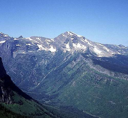
Heavens Peak from the east.
.
.
.
.
.
.
.
.
.
.
.
.
.
.
.

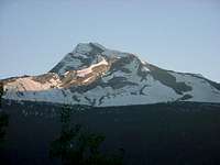
From the south.
Overview
Heavens Peak is the highest of four peaks that form the divide between Camas Creek and McDonald Creek at the head of Lake McDonald in Glacier National Park. It dominates the view west from much of the Going-to-the-Sun road and with its permanent snow is quite photogenic.
All the routes on Heavens Peak involve a long day of climbing with about 5,000 feet of elevation gain. Views from the summit are excellent in all directions.
From the northeast.
The descriptive name of this beautiful peak first appears on a map prepared by Lt. George P. Ahern of the 25th Infantry, from reconnaissance maps done in1888-1890.
Norman Clyde, Fred Herz, and Lee Stopple made the first recorded ascent of Heavens Peak via the North Ridge Route on 15 July 1924.
NPS full screen photo taken from the northeast: Heavens Peak
Getting There

From the east.
Glacier National Park is located in northwestern Montana. Going-to-the-Sun Road is the main scenic route through the Park and the way to Logan Pass and Heavens Peak. It is not kept open during the winter. Closing in the fall and opening in the spring depends on snow depth and conditions. Opening can be as late as July.
Current Road Status
Red Tape
Current Entrance Fees
Registration for day climbs in Glacier National Park is recommended, but not mandatory.
Outdoor Activity Page Includes links to boating, bicycling, fishing, etc. and the regulations applying to each.
Routes Overview
GUIDEBOOK: A CLIMBER'S GUIDE TO GLACIER NATIONAL PARK; J. Gordon Edwards
SPECIAL CONSIDERATIONS:
Because of the nature of the rock, there are special considerations regarding climbing in Glacier National Park, and grading systems unique to the Park have been developed. Please see this Fact Sheet for further details:
GNP Rock & Grading Systems
The current edition of the climbing guide should describe four routes on Heavens Peak. However, at least in the printing that I own (probably the first), there is a printing error. The description of the North Ridge Route is truncated and finishes with part of the description of the South Ridge Route which is missing its heading and first part. This is corrected in later printings. See the discussion under Miscellaneous Info for a brief description of the grading system.
1) North Ridge Route, Mostly Glacier Park class 2 & 3 possibly with one class 4 spot and possible steep snow.
This route is most easily accessed from Arrow Lake (see route description).
It can also be accessed from the big switchback on the Going-to-the-Sun Road (The Loop). The distance to the summit is about 12 miles, 8 by trail. Old trails (condition?) are followed to an old fire lookout on the end of the north ridge. From there, the ridge is climbed to the summit.

S Ridge Route
2) South Ridge Route, Glacier Park class 3, but Edwards recommends the route for experienced mountaineers only.
One ascends a steep brushy streambed to the notch between Heavens Peak and McPartland Mountain, then climbs the steep south ridge almost to the summit. Access to the streambed involves fording McDonald Creek or crossing on logs near the start of the streambed in question. The guidebook recommends leaving the ridge when it becomes "too shear for safety" then traversing onto the west face and up easier slopes to the summit.
3) East Face Route, Glacier Park class 3 with steep snow.
McDonald Creek is forded just south of Logan Creek and one of two gullies is climbed to the top of Glacier Wall (thick brush). From there, the east ridge and face are climbed to the top of the North Ridge Route and on to the top.
4) Northeast Ridge Route, no grade given
The only description of this route given is that it is a very steep ridge complicated by snow and ice.
When to Climb
[img:88048:alignright:small:On South Ridge.]
June, July, August, September, and even into October depending on the amount of snow and the road closure.
Mountain Conditions
Weather Page an overview with a link to the local forecast.
Webcam Page
Camping
The Avalanche Campgound is the closest to Heavens Peak and there are numerous other campgrounds available within Glacier National Park:
Backcountry Camping Page Includes trail status reports, campground availability, daily backcountry bulletins, and a backcountry blog.
Car Camping Page
There are also many campgrounds just outside the Park on both the west and east sides.
Camping on the Blackfeet Reservation is restricted to established campgrounds only.
External Links
Glacier National Park Homepage
Glacier Mountaineering Society
Non-government Glacier National Park Information
geoinmt - Sep 3, 2015 11:05 am - Hasn't voted
Heavens peakThe parking pull out for the east face route is more like 7.5 miles from Lake McDonald Hotel. The couloir that gets you to the ridge starts at the top of the highest scree cone visible when you reach the upper basin.